Woolley Bridge: Difference between revisions
Jump to navigation
Jump to search
Created page with "{{Infobox town |name=Woolley Bridge |county=Derbyshire |picture=Woolley bridge.jpg |picture caption=Woolley Bridge |os grid ref=SK010956 |latitude=53.457844 |longitude=-1.9862..." |
m RB moved page Wooley Bridge to Woolley Bridge |
(No difference)
| |
Latest revision as of 19:39, 23 June 2021
| Woolley Bridge | |
| Derbyshire | |
|---|---|
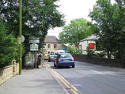
 Woolley Bridge | |
| Location | |
| Grid reference: | SK010956 |
| Location: | 53°27’28"N, 1°59’10"W |
| Data | |
| Local Government | |
| Council: | High Peak |
Woolley Bridge is a village in Derbyshire, at the edge and contiguous with Hadfield. It is within Glossopdale at the north-westernmost of the county, and stands beside the River Etherow which here marks the border of Cheshire.
Nearby places include Hollingworth, Dinting Vale, Gamesley, Glossop and Mottram.
Outside links
| ("Wikimedia Commons" has material about Woolley Bridge) |
References

This Derbyshire article is a stub: help to improve Wikishire by building it up.
