Difference between revisions of "Nether Haugh"
From Wikishire
(Created page with "{{Infobox town |name=Nether Haugh |county=Yorkshire |riding=West |picture=Nether Haugh - geograph.org.uk - 959111.jpg |picture caption= |os grid ref=SK417969 |latitude=53.4675...") |
(No difference)
|
Latest revision as of 21:03, 3 October 2020
| Nether Haugh | |
| Yorkshire West Riding | |
|---|---|

| |
| Location | |
| Grid reference: | SK417969 |
| Location: | 53°28’3"N, 1°22’19"W |
| Data | |
| Postcode: | S62 |
| Local Government | |
| Council: | Rotherham |
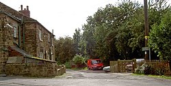
Nether Haugh is a little village in the West Riding of Yorkshire, strung along a single lane between Upper Haugh and Greasborough, two miles north of Rotherham.
See also
| ("Wikimedia Commons" has material about Nether Haugh) |