Carterton: Difference between revisions
Created page with '{{Infobox town |name= Carterton |county=Oxfordshire |picture= |picture caption= |latitude= 51.756 |longitude= -1.587 |os grid ref= SP2806 |population= 11,805 |census year= 200…' |
No edit summary |
||
| Line 2: | Line 2: | ||
|name= Carterton | |name= Carterton | ||
|county=Oxfordshire | |county=Oxfordshire | ||
|picture= | |picture= Carterton TowerCentre portrait.jpg | ||
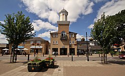
|picture caption= | |picture caption= The Tower Centre | ||
|latitude= 51.756 | |latitude= 51.756 | ||
|longitude= -1.587 | |longitude= -1.587 | ||
| Line 16: | Line 16: | ||
|website= [http://carterton-tc.gov.uk/ Carterton Town Council] | |website= [http://carterton-tc.gov.uk/ Carterton Town Council] | ||
}} | }} | ||
'''Carterton''' is a large town in western [[Oxfordshire]]. It is not an ancient town but was established by, and named after, William Carter in the early twentieth century. Carterton stands situated some | '''Carterton''' is a large town in western [[Oxfordshire]]. It is not an ancient town but was established by, and named after, William Carter in the early twentieth century. Carterton stands situated some two miles south of the A40 and four miles south-west of [[Witney]]. The town lies on the edge of the Thames Valley and is close to the [[Cotswolds]] area of outstanding natural beauty. | ||
==Churches== | ==Churches== | ||
| Line 26: | Line 26: | ||
Carterton was built about 1¼ miles from The East Gloucestershire Railway between Witney and Fairford stations. The line had been built in 1873 and had subsequently been taken over by the Great Western Railway. In 1944 the GWR opened Carterton station on the line, but in 1962 British Railways closed the line and the station.<ref>[http://www.d.m.howse.btinternet.co.uk/homepage.html Witney & East Gloucestershire Railway]</ref> | Carterton was built about 1¼ miles from The East Gloucestershire Railway between Witney and Fairford stations. The line had been built in 1873 and had subsequently been taken over by the Great Western Railway. In 1944 the GWR opened Carterton station on the line, but in 1962 British Railways closed the line and the station.<ref>[http://www.d.m.howse.btinternet.co.uk/homepage.html Witney & East Gloucestershire Railway]</ref> | ||
[[RAF Brize Norton]] was established in 1937 between Carterton and the railway line. The airbase's presence led Carterton to grow rapidly during the Second World War. The Royal Air Force is still one of the main employers in the area. The link with the air base also means that the population of Carterton continually fluctuates. There is also a significant proportion of retired RAF personnel living in the town. | |||
A regular visitor in the 1940s was the painter LS Lowry, who had a sister in the town. He painted the market square in Witney in 1949, a reproduction of which can be seen at Lea's, the Opticians, just off the square. The original is in a private collection in Cheshire. | A regular visitor in the 1940s was the painter LS Lowry, who had a sister in the town. He painted the market square in Witney in 1949, a reproduction of which can be seen at Lea's, the Opticians, just off the square. The original is in a private collection in Cheshire. | ||
Latest revision as of 15:09, 17 March 2020
| Carterton | |
| Oxfordshire | |
|---|---|
 The Tower Centre | |
| Location | |
| Grid reference: | SP2806 |
| Location: | 51°45’22"N, 1°35’13"W |
| Data | |
| Population: | 11,805 (2001) |
| Post town: | Witney |
| Postcode: | OX18 |
| Dialling code: | 01993 |
| Local Government | |
| Council: | West Oxfordshire |
| Parliamentary constituency: |
Witney |
| Website: | Carterton Town Council |
Carterton is a large town in western Oxfordshire. It is not an ancient town but was established by, and named after, William Carter in the early twentieth century. Carterton stands situated some two miles south of the A40 and four miles south-west of Witney. The town lies on the edge of the Thames Valley and is close to the Cotswolds area of outstanding natural beauty.
Churches
- Church of England: St John the Evangelist
History
Until the early 20th century, the Carterton area was farmland and belonged to the parish of Black Bourton. The land was then sold to William Carter, the director of a building company.
Carterton was built about 1¼ miles from The East Gloucestershire Railway between Witney and Fairford stations. The line had been built in 1873 and had subsequently been taken over by the Great Western Railway. In 1944 the GWR opened Carterton station on the line, but in 1962 British Railways closed the line and the station.[1]
RAF Brize Norton was established in 1937 between Carterton and the railway line. The airbase's presence led Carterton to grow rapidly during the Second World War. The Royal Air Force is still one of the main employers in the area. The link with the air base also means that the population of Carterton continually fluctuates. There is also a significant proportion of retired RAF personnel living in the town.
A regular visitor in the 1940s was the painter LS Lowry, who had a sister in the town. He painted the market square in Witney in 1949, a reproduction of which can be seen at Lea's, the Opticians, just off the square. The original is in a private collection in Cheshire.
In the first decade of the 21st century the new Shilton Park district of northeast Carterton was built, providing a mix of housing for private ownership and social letting. The new St John's Church of England primary school has been built at Shilton Park and construction of a local shopping centre is now complete.