Gas Street Basin: Difference between revisions
m →Outside links: ioe -> nhle, replaced: {{IoE|217098 → {{NHLE|1075602, {{IoE|216826 → {{NHLE|1075688, {{IoE|217097 → {{NHLE|1211058, {{IoE|217096 → {{NHLE|1343397 |
No edit summary |
||
| Line 1: | Line 1: | ||
{{county|Warwickshire}} | {{county|Warwickshire}} | ||
[[Image:Gas Street Basin Worcester Bar.jpg|right|thumb|The Worcester Bar, facing north-east]] | [[Image:Gas Street Basin Worcester Bar.jpg|right|thumb|The Worcester Bar, facing north-east]] | ||
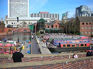
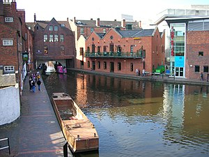
[[Image:Gas Street Basin towards Mailbox.jpg|right|thumb|The start of the Worcester and Birmingham Canal at Gas Street Basin, looking towards The Mailbox, viewed from the Worcester bar bridge, facing south-east]] | [[Image:Gas Street Basin towards Mailbox.jpg|right|thumb|The start of the Worcester and Birmingham Canal at Gas Street Basin, looking towards The Mailbox, viewed from the Worcester bar bridge, facing south-east]] | ||
| Line 6: | Line 5: | ||
==History== | ==History== | ||
The Birmingham Canal, completed in 1773, terminated at Old Wharf beyond Bridge Street. When the Worcester and Birmingham Company started their canal at a point later known as Gas Street Basin the [[Birmingham Canal Navigations]] Company (BCN) insisted on a physical barrier to prevent the Worcester and Birmingham Canal from benefiting from their water. The '''Worcester Bar''', a 7 | [[Image:Gas Street Basin towards Brindleyplace.jpg|right|thumb|The start of the BCN at Gas Street Basin, looking towards Brindleyplace, viewed from the Worcester bar bridge, facing north-west. [[Old Turn Junction]] is just through the short tunnel under Broad Street.]] | ||
The Birmingham Canal, completed in 1773, terminated at Old Wharf beyond Bridge Street. When the Worcester and Birmingham Company started their canal at a point later known as Gas Street Basin the [[Birmingham Canal Navigations]] Company (BCN) insisted on a physical barrier to prevent the Worcester and Birmingham Canal from benefiting from their water. The '''Worcester Bar''', a 7 ft 3 in-wide straight barrier 84 yards long was built perpendicular to the run of the two canals. Cargoes had to be laboriously manhandled between boats on either side. | |||
The Worcester and Birmingham Canal opened between Birmingham and [[Selly Oak]] on 30 October 1795 but took until 1815 to complete to [[Worcester]], at which time, after much lobbying by iron and coal masters and the Worcester and Birmingham Canal Company, an Act of Parliament was passed to open up the bar and the bar lock was built. There were toll offices either side of the bar lock and tolls were collected by each company from boats using the canals. The Worcester Bar still exists, with boats moored to both sides of it. It is connected to Gas Street via a footbridge reconstructed to a design by Horseley Ironworks of the 19th century. | The Worcester and Birmingham Canal opened between Birmingham and [[Selly Oak]] on 30 October 1795 but took until 1815 to complete to [[Worcester]], at which time, after much lobbying by iron and coal masters and the Worcester and Birmingham Canal Company, an Act of Parliament was passed to open up the bar and the bar lock was built. There were toll offices either side of the bar lock and tolls were collected by each company from boats using the canals. The Worcester Bar still exists, with boats moored to both sides of it. It is connected to Gas Street via a footbridge reconstructed to a design by Horseley Ironworks of the 19th century. | ||
Latest revision as of 10:28, 13 March 2020


Gas Street Basin is a canal basin in Birmingham 1, Warwickshire, where the Worcester and Birmingham Canal meets the BCN Main Line. It is located on Gas Street, off Broad Street, and between the Mailbox and Brindleyplace canal-side developments.
History

The Birmingham Canal, completed in 1773, terminated at Old Wharf beyond Bridge Street. When the Worcester and Birmingham Company started their canal at a point later known as Gas Street Basin the Birmingham Canal Navigations Company (BCN) insisted on a physical barrier to prevent the Worcester and Birmingham Canal from benefiting from their water. The Worcester Bar, a 7 ft 3 in-wide straight barrier 84 yards long was built perpendicular to the run of the two canals. Cargoes had to be laboriously manhandled between boats on either side.
The Worcester and Birmingham Canal opened between Birmingham and Selly Oak on 30 October 1795 but took until 1815 to complete to Worcester, at which time, after much lobbying by iron and coal masters and the Worcester and Birmingham Canal Company, an Act of Parliament was passed to open up the bar and the bar lock was built. There were toll offices either side of the bar lock and tolls were collected by each company from boats using the canals. The Worcester Bar still exists, with boats moored to both sides of it. It is connected to Gas Street via a footbridge reconstructed to a design by Horseley Ironworks of the 19th century.
During the 1990s much of the area around the basin was redeveloped and older buildings refurbished.
The wall and ramp down from Gas Street, the Tap and Spile pub, and the neighbouring building are all Grade II-listed, as is the Martin & Chamberlain building built on top of the Broad Street Tunnel.
In 1973, the basin featured prominently in the Cliff Richard film Take Me High. A canal-side cottage there was used as the home of a character in the long-running soap opera Crossroads.
Gallery
-
Grade II-listed steps and wall giving access from Gas Street
-
The Worcester Bar stop lock (gates removed)
References
- Ray Shill (1994). A Gas Street Trail. Heartland Press. ISBN 0-9517755-3-7.
Outside links
| ("Wikimedia Commons" has material about Gas Street Basin) |
- Location map: 52°28’39"N, 1°54’34"W
- Birmingham City Council canal pages
- National Heritage List 1075602: Wall and steps
- National Heritage List 1343397: 10-12 Gas Street (Tap and Spile pub)
- National Heritage List 1211058: 14-16 Gas Street
- National Heritage List 1075688: 266 Broad Street (building built on tunnel)
| The Birmingham Canal Navigations | ||
|---|---|---|
| Navigable: |
BCN Main Line • Birmingham and Fazeley Canal • Bumble Hole Branch Canal • Cannock Extension Canal • Digbeth Branch Canal • Dudley Canal • Engine Arm • Gower Branch Canal • Icknield Port Loop • Netherton Tunnel Branch Canal • Rushall Canal • Soho Loop • Spon Lane Locks Branch • Tame Valley Canal • Titford Canal • Walsall Canal • Wednesbury Oak Loop • Wednesbury Old Canal • Wyrley and Essington Canal | |
| Unnavigable: |
Anson Branch • Bentley Canal • Bradley Branch • Lichfield Canal • Ridgacre Branch • Tipton Green and Toll End Canals | |


