Radcliffe, Lancashire: Difference between revisions
Created page with "{{Infobox town |name=Radcliffe |county=Lancashire |picture=St thomas church radcliffe greater manchester2.jpg |picture caption=St Thomas and St John with St Philip Church |os..." |
m →Sights of the town: ioe -> nhle, replaced: {{IoE|210617 → {{NHLE|1163125, {{IoE|210639 → {{NHLE|1309271, {{IoE|210607 → {{NHLE|1356793 |
||
| Line 71: | Line 71: | ||
==Sights of the town== | ==Sights of the town== | ||
[[File:Radcliffe cenotaph.jpg|thumb|upright|Radcliffe Cenotaph]] | [[File:Radcliffe cenotaph.jpg|thumb|upright|Radcliffe Cenotaph]] | ||
[[Radcliffe Tower]] is all that remains of an early 15th-century stone-built manor house. The structure is Grade I listed.<ref name=ps>{{pastscape|44210|Radcliffe Tower}}</ref><ref name=ioe>{{ | [[Radcliffe Tower]] is all that remains of an early 15th-century stone-built manor house. The structure is Grade I listed.<ref name=ps>{{pastscape|44210|Radcliffe Tower}}</ref><ref name=ioe>{{NHLE|1309271|Radcliffe Tower}}</ref> | ||
The construction of a nearby tithe barn is not documented, but it was probably built between 1600 and 1720.<ref>{{pastscape|44213|Tithe barn}}</ref> It was used for storage of the local tithes.<ref>{{Harvnb|Darvill|2003|p=433.}}</ref> | The construction of a nearby tithe barn is not documented, but it was probably built between 1600 and 1720.<ref>{{pastscape|44213|Tithe barn}}</ref> It was used for storage of the local tithes.<ref>{{Harvnb|Darvill|2003|p=433.}}</ref> | ||
The Parish Church of St Mary is a Grade I listed building.<ref>{{ | The Parish Church of St Mary is a Grade I listed building.<ref>{{NHLE|1163125|Church of St Mary and St Bartholomew}}</ref> | ||
The town also has two Grade II* listed buildings: the town cenotaph and Dearden Fold Farmhouse, completed during the 16th century,<ref>{{ | The town also has two Grade II* listed buildings: the town cenotaph and Dearden Fold Farmhouse, completed during the 16th century,<ref>{{NHLE|1356793|Dearden Fold Farmhouse}}</ref> | ||
[[Outwood Viaduct]] is Grade II listed. | [[Outwood Viaduct]] is Grade II listed. | ||
Latest revision as of 09:06, 19 September 2019
| Radcliffe | |
| Lancashire | |
|---|---|
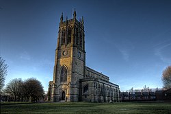 St Thomas and St John with St Philip Church | |
| Location | |
| Grid reference: | SD785075 |
| Location: | 53°33’41"N, 2°19’36"W |
| Data | |
| Population: | 34,239 (2001) |
| Post town: | Manchester |
| Postcode: | M26 |
| Dialling code: | 0161 |
| Local Government | |
| Council: | Bury |
| Parliamentary constituency: |
Bury South |
Radcliffe is a town in Lancashire, in the south of the county in the Irwell Valley two and a half miles south-west of Bury and six and a half miles north-northwest of Manchester. It has grown contiguous with Whitefield to the south. The disused Manchester, Bolton & Bury Canal bisects the town.
A Roman road passes through the area, along the bounds of Radcliffe and Bury. Radcliffe appears in an entry of the Domesday Book as "Radeclive" and in the High Middle Ages formed a small parish and township centred on the Church of St Mary and the manorial Radcliffe Tower, both of which are today Grade I listed buildings.
Coal lies under the area of mines opened in the Industrial Revolution, providing fuel for the cotton spinning and papermaking industries. By the mid-19th century, Radcliffe was an important mill town with cotton mills, bleachworks and a road, canal and railway network.[1]
With a population of 34,239, falling to 29,950 at the Census in 2011. The town is predominantly a residential area whose few remaining cotton mills are now occupied by small businesses.[1]
Name
The name 'Radcliffe' is derived from the Old English words read clif, meaning "Red cliff (or bank)",[2] referring to the bank of the River Irwell. The Domesday Book records the name as Radeclive.[3] Other archaic spellings include Radclive (recorded in 1227), and Radeclif (recorded in 1309 and 1360).[3]
The prominent Radcliffe family took its name from the town.[4]
History
Early history
Mesolithic traces from behaps 6,000BC were found in archaeological excavations in 1949 at Radcliffe E'es (a level plain along the north bank of the Irwell, formed by glacial deposits),[5] suggesting a lake village site. Further investigations in 1961 revealed rows of sharpened posts and worked timbers, but no further dating evidence was collected. In 1911 while repairs to the bridge at Radcliffe bridge were underway, a stone axe-hammer was found in the river bed, 8 ½ inches long and 4 lb in weight, made from polished quartzite, with a bore to take a shaft.[6] South of the present-day Withins reservoir is a possible location for a henge-form tumulus.[7]
A Roman road passes through the town, along the border between Radcliffe and Bury on a south-east to north-west route,[8] part of a route between the Roman forts at Manchester (Mamucium) and Ribchester (Bremetennacum).[9] The approximate route was through Higher Lane in nearby Whitefield, through Dales Lane and across the Irwell over Radcliffe E'es through the site of the former East Lancashire Paper Mill. The route passes up Croft Lane, over Cross Lane and over the route of the Manchester Bolton & Bury Canal under the 10¾ milestone. It then crosses Bury and Bolton Road, and heads through Higher Spen Moor.[10]
Other than placenames, little information about the area survives from the Dark Ages. Radcliffe was likely moorland and swamps.[4]
Following the Norman conquest, Radcliffe is recorded as a parish and township in the Salford Hundred of Lancashire;[11] one of only four parishes from the hundred mentioned in the Domesday Book as having been held by King Edward (the Confessor) as a Royal Manor,[4] it initially consisted of two hamlets; Radcliffe, near to the border with Bury and centred on the Mediæval Church of St Mary and the manorial Radcliffe Tower, and further to the west Radcliffe Bridge, at a crossing of the Irwell.[3] As a Royal Manor, the hide may originally have been up to four times the size it was when it was recorded in 1212 as being held by William de Radeclive, of the "Radclyffes of the Tower" family.[4]
In the 15th century the Pilkington family who, during the Wars of the Roses, supported the House of York, owned much of the land around the parish. Thomas Pilkington was at this time lord of many estates in Lancashire.[12][13] In 1485, after King Richard III was slain in the Battle of Bosworth, legend has it that Sir William Stanley placed the Crown of England on the head of the new king, Henry Tudor Earl of Richmond: certainly as a reward for the support of his family, on 27 October 1485 Henry made Thomas Stanley the Earl of Derby. Thomas Pilkington was attainted, and in February 1489 Earl Thomas was given many confiscated estates including those of Pilkington, which included the township of Pilkington, and Bury.[13]
During the Civil War Radcliffe, along with nearby Bolton, fought on the side of the Parliamentarians against the Royalist Bury.
In 1561 after about 400 years rule by the Radclyffes, Robert Assheton (Lord of the Manor of Middleton) bought the manor of Radcliffe for 2,000 Marks.[3][14] From 1765 the Assheton estates were divided between the two daughters of the late Ralph Assheton, one of whom married Thomas Egerton, 1st Earl of Wilton. The manor of Radcliffe appears to have been included in her share, and thereafter was included in the Wilton estates.[3]
Textiles and the Industrial Revolution
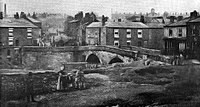
The first documented reference to industry in Radcliffe is after 1680, in the Radcliffe parish registers, which make increasing mention of occupations such as woollen webster (weaving), linen webster, and whitster (bleacher). These were cottage industries which worked alongside local agriculture. In 1780 Robert Peel built the first factory in the town, several hundred yards upstream from Radcliffe Bridge (at the end of Peel Street). With a weir and goit providing motive power for a water wheel, the factory was built for throstle spinning and the weaving of cotton—a relatively new introduction to Britain. The water wheel proved to be insufficient, and so around 1804 the goit was extended. The weir (known as Rectory Weir) was made from timber.[15] Conditions were poor; the mill employed child labour bought from workhouses in Birmingham and London. Children were boarded on an upper floor of the building, and bound until they reached the age of 21. They were unpaid, and were kept locked up each night. Shifts were typically 10–10.5 hours in length, and children returning from a day shift would sleep in the same bed as children leaving for a night shift. Peel himself admitted that conditions at the mill were "very bad".[16] In 1784 an outbreak of typhoid prompted Lord Grey de Wilton to inform the magistrates of Salfordshire;[17] keen to prevent the spread of the disease to neighbouring towns and villages, they sent doctors to assess the situation. Their recommendations included leaving the windows of the mill open at night, fumigation of rooms with tobacco (as this was thought to discourage disease), regular cleaning of rooms and toilets and occasional bathing of children.[18] The report forced the magistrates, led by Thomas Butterworth Bayley, to abandon the practice of binding parish apprentices to any mill not adhering to these conditions. The report also prompted Peel to introduce an Act of Parliament to improve factory hygiene, which later became the Factory Act of 1802.[19][20] Over time, conditions at the mill improved; in the mid-1790s the physician John Aikin, a critic of the factory system, praised working conditions at the mill,[21] and in 1823 inspections by local magistrates of conditions in mills across the county revealed that unlike many others, the factory at Radcliffe was adhering to all requirements of the Factory Acts.[22]
The underlying coal measures throughout the parish were a valuable source of fuel. Radcliffe already had an established textile industry before the arrival of steam power. The first recorded instance of coal getting in Lancashire was in 1246, when Adam de Radeclyve was fined for digging de minera on common land in the Radcliffe area. Coal outcroppings were not uncommon; as recently as 1936 members of the public were seen carrying away large pieces of coal from a seam revealed by the landslip caused when the Manchester, Bolton & Bury Canal breached at Ladyshore. Mining was initially limited to bell pits until the arrival of steam engines, which along with improved ventilation, made possible much deeper pits. The earliest known local use of such an engine was in 1792 at Black Cat Colliery. The parish of Radcliffe was once home to as many as 50 pits, but with the exceptions of Outwood Colliery and Ladyshore Colliery, all were either exhausted or closed by the end of the 19th century. During the 1926 General Strike many striking miners illegally took coal from exposed seams around the Coney Green area of the town, to sell to local housewives. In the 1950s to the north of the town the National Coal Board did some open cast mining near Radcliffe Moor Road, but the last legal instance of coal mining in Radcliffe was between 1931 and 1949, close to Bury and Bolton Road.[23]
The transformation of the area from an industry based upon water power, to one based upon steam power, may not have been without problems. A story in W. Nicholl's History and Traditions of Radcliffe (1900) tells of a "great crowd" of protesters from Bury who marched on Bealey's Works, demanding that work be halted. James Booth ordered the gates closed, gave the ringleaders £5, and promised to halt work the next day. The crowd then marched on other businesses within the town before heading along the canal to Bolton, at which point they were apparently turned back by news of approaching soldiers.[24]
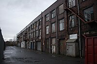
There were many smaller textile concerns in the parish. Thomas Howarth owned a cottage in Stand Lane from where he sent yarn to be dyed and sized. He made his own warps which were woven in the town. He would then travel to Preston and Kendal where drapers would purchase his products. His nephews founded A. & J. Hoyle's Mill in Irwell Street, which employed power weaving to produce their specialities in Ginghams and shirting. The mill closed in 1968. Messrs Stott & Pickstone's Top Shop on Stand Lane was the first company to employ powered looms and spinning around 1844. Many of their employees would eventually leave to start their own businesses, such as Spider Mill, built by Robert and William Fletcher, and John Pickstone. This mill closed around 1930.[25]
Radcliffe was at one time home to around 60 textile mills and 15 spinning mills, along with 18 bleachworks of which the Bealey family were prominent owners.[26] However, the textile industry was not the town's major employer; other industries such as mining and paper making were also important sources of employment.[27]
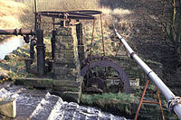
Mount Sion Mill along Sion Street was founded in the early 19th century and during the First World War manufactured guncotton. A weir was constructed along with a goit, used to turn a water wheel which powered a beam engine to pump water to the reservoirs above.[28][29]
Radcliffe became well known for its paper industry; its mills included the East Lancashire Paper Mill and Radcliffe Paper Mill. The former was founded by the Seddon family on 29 March 1860, along the banks of the Irwell. Its construction provided much-needed employment: in the 1860s living standards within the town were poor, and local mills often operated on "short time". A reduction in the demand for coal had placed many colliers out of work, and the Lancashire Cotton Famine was starving Lancashire of raw materials, especially cotton. Soup kitchens were opened by local benefactors, and many local residents were on poor relief. The mill began producing low grade paper and newsprint, moving on to other products including high quality printing and writing papers. Radcliffe Paper Mill was formed during the First World War, when it took over from a paper mill and a pipe plant. It originally produced paper suitable for roofing felt, to cater for a national shortage. After Second World War the mill employed over 600 people and produced 70,000 tons of paper annually. British Plaster Board Industries (BPB) took over the company in 1961.[30]
Other industries in the town included brick making and chimney pot manufacture. Raw materials were sourced from local collieries. In Mill Street carts, waggons, and bicycles were manufactured from 1855, and elsewhere motor vehicles were also produced until the late 1950s. John Cockerill moved to the town from Haslingden before leaving for continental Europe to become the founder of Cockerill-Sambre. James Cockerill, employed Radcliffe man William Yates as his manager. Several foundries and machine manufacturers were located around the town, including Dobson and Barlow at Bradley Fold, and Wolstenholme's along Bridgewater Street. Munitions, aircraft and tank components were manufactured during the Second World War. Chemicals were manufactured by companies such as Bealey's and J. & W. Whewell.[31]
Post-industrial history
From the 1950s Radcliffe's textile industry went into terminal decline, and although its paper industry survived to the end of the 20th century, both the town's largest paper mills have now been closed and demolished. One of the larger mills in Radcliffe was the Pioneer Mill, built between 1905 and 1906, and which ceased weaving in July 1980—the last mill in Radcliffe to use cotton.[32] The building is now occupied by several different businesses.
Although the town retains much of its existing Victorian and Edwardian housing stock, new estates have been built on former brownfield land including that of the Radcliffe Paper Mill Company.[33] Since deindustrialisation the local population has continued to grow.[34] Radcliffe's housing stock of 23,790 properties is a mixture of mainly semi-detached and terraced housing, with smaller percentages of detached housing and flats.
Sights of the town
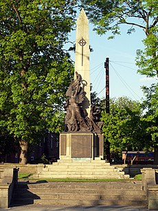
Radcliffe Tower is all that remains of an early 15th-century stone-built manor house. The structure is Grade I listed.[35][36]
The construction of a nearby tithe barn is not documented, but it was probably built between 1600 and 1720.[37] It was used for storage of the local tithes.[38]
The Parish Church of St Mary is a Grade I listed building.[39]
The town also has two Grade II* listed buildings: the town cenotaph and Dearden Fold Farmhouse, completed during the 16th century,[40]
Outwood Viaduct is Grade II listed.
Churches
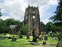
St Mary’s. the original parish church was built during the 14th century, and the tower added in the 15th century.[41]
The Church of St Thomas is a Victorian church, which took nine years to complete. The first stone was laid by Viscount Grey de Wilton (grandson of the Countess Grosvenor) on 21 July 1862, and it was consecrated in 1864 by the first Bishop of Manchester, James Prince Lee. Construction of the tower began in 1870[42] and the building was completed in 1871.
- Church of England:
- Baptist: Trinity Baptist Church
- Methodist: The Bridge
- United Reformed Church: two congregations, on Lord Street and on Stand Lane
- Roman Catholic: St Mary & St Philip Neri
Sport
- Cricket: Radcliffe Cricket Club
- Football:
- Radcliffe Town[45]
- Radcliffe Borough
- Rugby
Culture and leisure
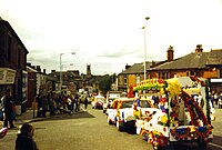
Radcliffe Brass Band has performed in the town since 1914, when it accompanied one of the Whit Walks that used to take place on Whit Friday.[46]
Rushcart processions were once popular, held on the first Saturday of September, finishing on the following Sunday at the Parish Church,[47] but this tradition has died out.
The town has several parks, including Coronation Park near Radcliffe Bridge and Close Park near Radcliffe Tower. Much of the land for Coronation Park was in 1900 donated by the Earl of Derby. Close House and the grounds around it were formerly the home of the Bealey family, and were donated by the Bleachers' Association.
Outside links
| ("Wikimedia Commons" has material about Radcliffe, Lancashire) |
- Reinventing Radcliffe
- East Lancs Paper Mill advert – British Association of Paper Historians
References
- ↑ 1.0 1.1 McNeil & Nevell 2000, pp. 24–25.
- ↑ Mills 1998, p. 292.
- ↑ 3.0 3.1 3.2 3.3 3.4 Farrer & Brownbill 1911c, pp. 56–67.
- ↑ 4.0 4.1 4.2 4.3 Sunderland 1995, p. 15.
- ↑ Sunderland 1995, p. 10.
- ↑ Sunderland 1995, pp. 10–11.
- ↑ Bury Archaeological Project, Bury Metropolitan Borough Council, archived from the original on 9 January 2009, https://web.archive.org/web/20090109145930/http://www.bury.gov.uk/Environment/Planning/PlanningProjects/PastProjects/BAP.htm, retrieved 9 February 2009
- ↑ Simpson 1852, p. 98.
- ↑ Roman Roads in Lancashire, Lancashire County Council, archived from the original on 8 April 2008, https://web.archive.org/web/20080408110915/http://www.lancscc.gov.uk/environment/historichighways/roman2.asp, retrieved 26 October 2008
- ↑ Sunderland 1995, p. 11.
- ↑ Farrer & Brownbill 1911a, pp. 171–173.
- ↑ Farrer & Brownbill 1911b, pp. 88–92.
- ↑ 13.0 13.1 Coward 1983, pp. 13–14.
- ↑ Sunderland 1995, p. 17.
- ↑ Nicholls 1900, p. 164.
- ↑ Augusta & Ramsay 1969, p. 5.
- ↑ Landau 2002, p. 238.
- ↑ Meiklejohn, A. (16 January 1959), "Outbreak of Fever in Cotton Mills at Radcliffe, 1784", British Journal of Industrial Medicine (British Journal of Industrial Medicine) 16 (1): 68
- ↑ Sunderland 1995, p. 65.
- ↑ Russell 2001, p. 86.
- ↑ Landau 2002, p. 248.
- ↑ Augusta & Ramsay 1969, p. 73.
- ↑ Sunderland 1995, pp. 83–85.
- ↑ Nicholls 1900, pp. 167–168.
- ↑ Sunderland 1995, pp. 65–66.
- ↑ Sunderland 1995, p. 67.
- ↑ Sunderland 1995, p. 68.
- ↑ This engine was mentioned in Sunderland's Book of Radcliffe (1995) as existing at the time of publication.
- ↑ Sunderland 1995, p. 73.
- ↑ Sunderland 1995, p. 74.
- ↑ Sunderland 1995, pp. 78–79.
- ↑ Sunderland 1995, p. 66.
- ↑ Cite error: Invalid
<ref>tag; no text was provided for refs namedren1 - ↑ see Population and employment change
- ↑ National Monuments Record: No. 44210 – Radcliffe Tower
- ↑ National Heritage List 1309271: Radcliffe Tower
- ↑ National Monuments Record: No. 44213 – Tithe barn
- ↑ Darvill 2003, p. 433.
- ↑ National Heritage List 1163125: Church of St Mary and St Bartholomew
- ↑ National Heritage List 1356793: Dearden Fold Farmhouse
- ↑ St Mary’s, Radcliffe
- ↑ Gooderson 1985, p. 14.
- ↑ St Andrew's, Radcliffe
- ↑ St Thomas and St John, Radcliffe
- ↑ Radcliffe Town Football Club
- ↑ 'Band Love Being Back in Town' – Bury Times 27 September 2008
- ↑ Nicholls 1900, p. 210.
- East Lancashire Annual and Historical Record and Business Directory, c. 1905
- Augusta, Anna; Ramsay, Whittall (1969), Sir Robert Peel, Ayer Publishing, ISBN 0-8369-5076-3, https://books.google.com/?id=gpWMYC4HP3IC
- Borough of Radcliffe (21 September 1935), Charter Celebrations, Bury Library Local Studies
- Coward, Barry (1983), The Stanleys, Lords Stanley, and Earls of Derby, 1385—1672, Manchester University Press ND, ISBN 0-7190-1338-0, https://books.google.com/?id=5367AAAAIAAJ
- Darvill, Timothy (2003), The Concise Oxford Dictionary of Archaeology, Oxford University Press, ISBN 978-0-19-280005-3
- Dobb, Rev Arthur Joseph, Vicar of Bircle (1970), 1846 Before and After—A Historical Guide to the Ancient Parish of Bury, Rochdale Library: Bircle Parish Church Council
- Farrer, William; Brownbill, John (1911a), "The Hundred of Salford", A History of the County of Lancaster, Vol. 4 (British History Online), http://www.british-history.ac.uk/report.aspx?compid=41403, retrieved 12 December 2008
- The Parish of Prestwich with Oldham—Pilkington – A History of the County of Lancaster - Volume : {{{2}}} (Victoria County History)
- The Parish of Radcliffe A History of the County of Lancaster - Volume : {{{2}}} (Victoria County History)
- Frost, Roy (1993), Electricity in Manchester, Roy Frost, ISBN 1-85216-075-6
- Gooderson, P.J. (1985), Thomas & John, Radcliffe Library: RAP ltd, ISBN 0-9510489-0-2
- Hudson, John (2001), Britain in Old Photographs—Radclffe, Budding Books, ISBN 1-84015-219-2
- Landau, Norma (2002), Law, Crime and English Society, 1660–1830, Cambridge University Press, ISBN 0-521-64261-2, https://books.google.com/?id=RL9up6t2fVQC
- Langley, W. H. (1854), Ruff's Guide to the Turf, Piper, Stephenson and Spence, https://books.google.com/?id=pOQNAAAAQAAJ
- McNeil, R; Nevell, M (2000), A Guide to the Industrial Archaeology of Greater Manchester, Association for Industrial Archaeology, ISBN 0-9528930-3-7
- Mills, A.D. (1998), "Radcliffe", A Dictionary of British Place-Names (2nd ed.), Oxford Reference Online. Oxford University Press. Manchester Library & Information Service.: Oxford University Press, ISBN 0-19-280074-4, http://www.oxfordreference.com/views/ENTRY.html?subview=Main&entry=t40.e10718, retrieved 21 November 2008
- Nicholls, W (1900), History and Traditions of Radcliffe, John Heywood ltd
- Russell, Bertrand (2001), Freedom and Organisation, 1814–1819, Routledge, ISBN 0-415-24999-6, https://books.google.com/?id=3_XSJ0s1wiMC
- Simpson, Robert (1852), The History and Antiquities of the Town of Lancaster, Oxford University: T. Edmondson; J.R. Smith, https://books.google.com/?id=9xQHAAAAQAAJ
- Simpson, Barry J. (1994), Urban Public Transport Today, Taylor & Francis, ISBN 0-419-18780-4, https://books.google.com/?id=9XNisrM1gAQC
- Smith, Leah (1981), Bits of Local History by "Owd Linthrin Bant", Radcliffe Library: Radcliffe Local History Society 1981
- Sunderland, Frank (1995), The Book of Radcliffe, Bury Library Local Studies: Baron Birch, ISBN 0-86023-561-0, http://www.amazon.co.uk/Book-Radcliffe-Town/dp/0860235610
- Wells, Jeffrey (1995), An Illustrated Historical Survey of the Railways in and Around Bury, Challenger Publications, ISBN 1-899624-29-5
