Difference between revisions of "Achnahuaigh"
From Wikishire
(Created page with "{{Infobox town |name=Achnahuaigh |county=Sutherland |picture=Achnahuaigh - geograph.org.uk - 164340.jpg |picture caption=Ruined croft house at Achnahuaigh |os grid ref=NC58064...") |
|||
| Line 15: | Line 15: | ||
|website= | |website= | ||
}} | }} | ||
| − | Achnahuaigh is a hamlet on the north coast of [[Sutherland]], and | + | '''Achnahuaigh''' is a hamlet on the north coast of [[Sutherland]], and thus of [[Great Britain]], on a track on the west side of the mouth of the [[Kyle of Tongue]], looking out towards the [[Rabbit Islands]]. |
The hamlet is to the north of a similar place, [[Talmine]], and all of a piece with the hamlet strung along the lane between them known as [[Melness]]. | The hamlet is to the north of a similar place, [[Talmine]], and all of a piece with the hamlet strung along the lane between them known as [[Melness]]. | ||
Latest revision as of 16:18, 3 April 2019
| Achnahuaigh | |
| Sutherland | |
|---|---|
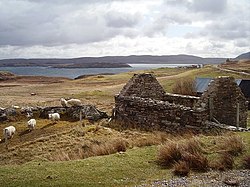
 Ruined croft house at Achnahuaigh | |
| Location | |
| Grid reference: | NC580642 |
| Location: | 58°32’33"N, 4°26’29"W |
| Data | |
| Postcode: | IV27 |
| Local Government | |
| Council: | Highland |
| Parliamentary constituency: |
Caithness, Sutherland and Easter Ross |
Achnahuaigh is a hamlet on the north coast of Sutherland, and thus of Great Britain, on a track on the west side of the mouth of the Kyle of Tongue, looking out towards the Rabbit Islands.
The hamlet is to the north of a similar place, Talmine, and all of a piece with the hamlet strung along the lane between them known as Melness.