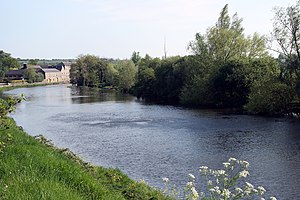
River Barrow: Difference between revisions
Created page with "{{county|Laois}} thumb|300p|River Barrow at Muine Bheag, County Carlow The '''Barrow''' is a river that flows from County Laois to the Irish Se..." |
No edit summary |
||
| Line 1: | Line 1: | ||
{{county|Laois}} | {{county|Laois}} | ||
[[File:BarrowBagnel.jpg|thumb|300p|River Barrow at | [[File:BarrowBagnel.jpg|thumb|300p|River Barrow at Bagenalstown, County Carlow]] | ||
The '''Barrow''' is a river that flows from [[County Laois]] to the [[Irish Sea]] at [[Waterford]]. It is one of [[The Three Sisters]]; the other two being the [[River Suir]] and the [[River Nore]]. The Barrow is the longest of the three rivers. At 120 miles, it is the second-longest river in Ireland, behind the [[River Shannon]]. The catchment area of the River Barrow is nearly 1,200 square miles<ref>[http://www.serbd.com/MultiDownloads/Creport/Chapters/Physical%20Description%20Ch3.pdf South Eastern River Basin District Management System. Page 38]</ref> | The '''Barrow''' is a river that flows from [[County Laois]] to the [[Irish Sea]] at [[Waterford]]. It is one of [[The Three Sisters]]; the other two being the [[River Suir]] and the [[River Nore]]. The Barrow is the longest of the three rivers. At 120 miles, it is the second-longest river in Ireland, behind the [[River Shannon]]. The catchment area of the River Barrow is nearly 1,200 square miles<ref>[http://www.serbd.com/MultiDownloads/Creport/Chapters/Physical%20Description%20Ch3.pdf South Eastern River Basin District Management System. Page 38]</ref> | ||
The river's long term average flow rate is 50 cubic yards per second.<ref>[http://www.serbd.com/MultiDownloads/Creport/Chapters/Physical%20Description%20Ch3.pdf South Eastern River Basin District Management System. Page 38]</ref> | The river's long term average flow rate is 50 cubic yards per second.<ref>[http://www.serbd.com/MultiDownloads/Creport/Chapters/Physical%20Description%20Ch3.pdf South Eastern River Basin District Management System. Page 38]</ref> | ||
Latest revision as of 06:40, 29 May 2018

The Barrow is a river that flows from County Laois to the Irish Sea at Waterford. It is one of The Three Sisters; the other two being the River Suir and the River Nore. The Barrow is the longest of the three rivers. At 120 miles, it is the second-longest river in Ireland, behind the River Shannon. The catchment area of the River Barrow is nearly 1,200 square miles[1] The river's long term average flow rate is 50 cubic yards per second.[2]
The source of the River Barrow is at Glenbarrow in the Slieve Bloom Mountains in County Laois.
Among the towns that the River Barrow passes through on its way to the sea in Waterford are Portarlington, Monasterevin, Athy, Carlow/Graiguecullen, Bagenalstown, Graiguenamanagh, and New Ross.
The river forms a natural border between parts of the counties of Kilkenny and Carlow and Kilkenny and Wexford.
History
The earliest recorded name for the river is Berbha, from an AD 996 entry in the Annals of the Four Masters.
- Sloighedh la Domhnall ua Néill co Laighnibh co ros-indir o Bherbha siar go fairrge, & do-bert bóromha mhór lais, & do-rad forbhais for Ghallaibh, & for Laighnibh co cenn da mhíos. As don chur-sin torchair Fionn, mac Goirmghiolla, Dunghal mac Dúnghaile I Riagáin, & Ronán, mac Bruadair, mic Duibhgiolla, & aroile saor-chlanna do Laighnibh amaille friu.[3]
Translated:
- An army was led by Domnall ua Néill into Leinster; and he plundered from the Bearbha eastwards to the sea; and he carried off a great prey of cows; and he laid siege to the foreigners and the Leinstermen for two months. On this occasion were slain Fionn, son of Goirmghilla; Dunghal, son of Dunghal Ua Riagain; Ronan, son of Bruadar, son of Duibhghilla, and other nobles of the Leinstermen along with them.
The name Berbha is believed to refer to a river-goddess. Later spellings include Berba, Birga, Baruwe and Berrowe.[4]
There was a proverb quoted by Sir John Davies that “whoso lives by west of the Barrow, lives west of the law.”[5]
The River Barrow forms a major part of Ireland's inland waterways network, providing an inland link between the port of Waterford and the Grand Canal, which in turn connects Dublin to the River Shannon. There are three sections to the navigation:
- The tidal River Barrow, which together with the tidal reaches of its tributaries the River Suir and River Nore constitute 55 miles of tidal river navigation.
- The non-tidal river navigation featuring 23 locks, continuing 41 miles inland from the tidal limit of the Barrow at St Mullin's to Athy.
- The Barrow Line of the Grand Canal connects to the river at Athy and continues northwards a further 28 miles with nine locks, connecting to the mainline of the Grand Canal at Lowtown.
References
- ↑ South Eastern River Basin District Management System. Page 38
- ↑ South Eastern River Basin District Management System. Page 38
- ↑ [1]
- ↑ [2]
- ↑ Falkiner, Caesar Litton (1904). Illustrations of Irish history and topography, mainly of the seventeenth century. London: Longmans, Green, & Co. pp. 117. ISBN 1-144-76601-X. https://archive.org/stream/illustrationsir00jouvgoog#page/n145/mode/2up.
Outside links
| ("Wikimedia Commons" has material about Barrow River Barrow) |
- Barrow Valley Guide website
- RIver Barrow Website
- IWAI - The Barrow Navigation
- Barrow River Guide
- Location map of Irish Sea end point: 52°13’60"N, 6°58’0"W
