Coalville: Difference between revisions
No edit summary |
No edit summary |
||
| Line 15: | Line 15: | ||
|constituency=North West Leicestershire | |constituency=North West Leicestershire | ||
}} | }} | ||
'''Coalville''' is a town in north-western [[Leicestershire]]. Its name tells of its origin and its focus: it was created as a coal-mining town in the eighteenth century, and the marks of mining are everywhere, though the mines | '''Coalville''' is a town in north-western [[Leicestershire]]. Its name tells of its origin and its focus: it was created as a coal-mining town in the eighteenth century, and the marks of mining are everywhere, though the mines themselves closed in the 1990s. The town's population was estimated in 2003 to be almost 33,000. | ||
The town stands within the Leicestershire coalfield and by the transport routes of the area: the A511 trunk road between [[Leicester]] and [[Burton upon Trent]] and the M1 motorway. It is the market town for the district and despite its own black reputation, it edges the upland area of [[Charnwood Forest]] which lies to the town's east. | The town stands within the Leicestershire coalfield and by the transport routes of the area: the A511 trunk road between [[Leicester]] and [[Burton upon Trent]] and the M1 motorway. It is the market town for the district and despite its own black reputation, it edges the upland area of [[Charnwood Forest]] which lies to the town's east. | ||
Latest revision as of 20:29, 20 January 2018
| Coalville | |
| Leicestershire | |
|---|---|
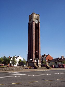
 Clock Tower | |
| Location | |
| Grid reference: | SK4213 |
| Location: | 52°43’1"N, 1°22’12"W |
| Data | |
| Population: | 32,987 (2003 est) |
| Post town: | Coalville |
| Postcode: | LE67 |
| Dialling code: | 01530 |
| Local Government | |
| Council: | North West Leicestershire |
| Parliamentary constituency: |
North West Leicestershire |
Coalville is a town in north-western Leicestershire. Its name tells of its origin and its focus: it was created as a coal-mining town in the eighteenth century, and the marks of mining are everywhere, though the mines themselves closed in the 1990s. The town's population was estimated in 2003 to be almost 33,000.
The town stands within the Leicestershire coalfield and by the transport routes of the area: the A511 trunk road between Leicester and Burton upon Trent and the M1 motorway. It is the market town for the district and despite its own black reputation, it edges the upland area of Charnwood Forest which lies to the town's east.
History

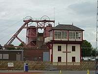
As the name indicates, Coalville is a former coal mining town. The owner of Whitwick Colliery named his own hoe nearby "Coalville House". Coal has been mined in the area since mediæval times and mine workings from these times can be found on the Hough Mill site at Swannington near the Califat Colliery site. A life-sized horse gin has been built on the Hough Mill site and craters can be seen in the ground, where the mediæval villagers dug out their allocation of coal. The seam is at ground level in Swannington, but gradually gets deeper between Swannington and the deepest reserves at Bagworth, so consequentially, it was not until mining technology advanced that shafts were sunk in Coalville. A disused colliery at Snibston has been regenerated into Snibston Discovery Park, a museum focused on transport, mining and engineering.
The town grew up with the advent of coal mining which was pioneered by William Stenson and involved the sinking of shafts on the Snibston site by George Stephenson. Quarrying, textile and engineering industries, such as railway wagon production, grew in the town in the 19th century. Stenson is sometimes described as the Father of Coalville.

The Leicester and Swannington Railway opened in 1832 reaching Coalville in 1833 and had a small station at Long Lane (now Ashby Road) in Coalville–-the first street in the town, which still has some of the original miners' cottages, which are next to the modern police station and opposite the sorting office. Snibston Colliery opened in 1833. The railway was extended to Burton upon Trent in 1845, placing Coalville on an important route between Burton and Leicester. Heavy coal traffic encouraged the construction of further railways linking Coalville to Nuneaton and Shepshed.
A fire underground at Whitwick Colliery led to the deaths of 35 men in 1898.
In the 20th century the railways to Nuneaton and Shepshed were closed and dismantled. Passenger services were withdrawn from the Leicester to Burton line in September 1964, but it remains open for goods traffic. Following the closure of the mines and the Palitoy Factory in the 1980s, the town fell on hard times. Effort was put into regeneration and the Whitwick Business Park now stands on top of the former Whitwick Colliery site. New business parks and industrial estates were constructed along the A511.
After 1993 there was an abortive plan to restore passenger trains on the Leicester-Burton line through Coalville as an extension of Leicestershire's Ivanhoe Line.
Churches
Coalville's parish church is Christ Church on London Road, built between 1836 and 1838. The architect was H I Stevens of Derby. The church houses a brass memorial plaque to the victims of the Whitwick Colliery Disaster (1898) and the gravestone of James Stephenson, who came here through the influence of his brother, George Stephenson, the engineer, to work as an official at the Snibston Colliery.
Churches include:
- Church of England:
- Christ Church (above)
- St David's, Broom Leys
- Baptist:
- Ebeneezer Baptist Church on Ashby Road was built in 1881 by a body of men and women who had previously belonged to the London Road Baptist Church (now demolished). The church once played a prominent part in the musical life of the town, and it was here that the Snibston Colliery Miner's Welfare Silver Prize Band was formed.[1]
- Independent Evangelical:
- Coalville Evangelical Church (affiliated with the Fellowship of Independent Evangelical Churches)
- St Margaret's Street Church Centre
- Methodist:
- Marlborough Square Methodist Church – Built as a Primitive Methodist Church in 1903, replacing an original built in 1861
- (The former Wesleyan Methodist Chapel is now used as a community resource, known as the Marlene Reed Centre. The 1910 United Methodist Church has since been demolished.)
- Pentecostal: Full Gospel Mission on James Street
- Roman Catholic: Saint Wilfred
War Memorial
A well known landmark at the centre of the town is the clock tower, a war memorial in memory of Coalville residents who gave their lives in the 20th century's two world wars: built in 1926 to the design of Henry Collings,[2] the tower rises 68 feet above pavement level and was opened by Mrs Charles Booth of Grace Dieu. This memorial was admired by Sir Nikolaus Pevsner.
Museums
Snibston Discovery Museum is built on a site of the former Snibston Colliery, and is located on Ashby Road. It features interactive exhibits, an 0-4-0ST steam locomotive, a fashion gallery and more. The museum focuses on technology and design and how it affects everyday life.
Donington le Heath Manor House Museum, a family home for 700 years, has been redeveloped into a museum in Coalville. The house has close connections to the Gunpowder Plot of 1605.
Outside links
| ("Wikimedia Commons" has material about Coalville) |
- Coalville Town Centre
- Churches in Coalville
- Maps of Coalville
- Examples of Coalville dialect
- Coalville on Leicestershire Villages
