Cowal: Difference between revisions
No edit summary |
|||
| Line 28: | Line 28: | ||
[[Category:Argyllshire]] | [[Category:Argyllshire]] | ||
[[Category:Peninsulas of Argyllshire]] | [[Category:Peninsulas of Argyllshire]] | ||
{{slippy}} | |||
Latest revision as of 11:27, 10 February 2017


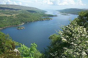
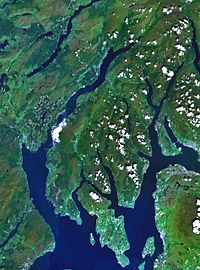
Cowal is a peninsula of Argyllshire, one of the distinctive districts of that county. It lies in the south of the county between Loch Fyne to the west, Loch Long to the east and the Firth of Clyde to the south, of which the Kyles of Bute separate Cowal from the Isle of Bute, the northernmost island of Buteshire.
Description
The northern part of Cowal is mostly the mountainous Argyll Forest Park. Loch Fyne separates Cowal from the Kintyre peninsula to the west, while the Loch Long parts Cowal from Dunbartonshire to the east and likewise the Firth of Clyde stretches between Cowal and Renfrewshire eastward. Loch Long and Loch Goil, two sea-lochs, lie to the north-east.
The south of Cowal is split into three forks by two further sea lochs; Loch Striven and Loch Riddon.
The Isle of Bute lies to the south of Cowal, separated from the peninsula by the narrow Kyles of Bute which connect the Clyde to Loch Riddon.
Much of Cowal was once held by the Lamont Clan; encroachments by the neighbouring Clan Campbell and other powerful families reduced the Lamont holdings in the Covenanting Wars of the seventeenth century.
Cowal's only burgh is Dunoon in the south-east,[1] from which ferries sail to Gourock in Renfrewshire. Other ferries run from Portavadie in the west to Tarbert on Kintyre, and from Colintraive in the south to Rhubodach on the Isle of Bute.
The Arrochar Alps and Ardgoil peninsula in the north fringe the edges of the sea lochs whilst the Argyll Forest Park spreads out across the hillsides and mountain passes in north part of Cowal, ensuring that while physically close to the bustling metropolis of Glasgow, Cowal remains nevertheless one of the most remote areas in the land.
| <slippymap lat="56.017" lon="-5.133" z="2" w="240" h="290" layer="colour"/> |