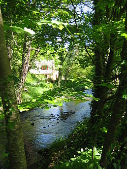
Biel Water: Difference between revisions
Created page with "right|thumb|250px|Biel Mill on the Biel Water {{county|East Lothian}} The '''Biel Water''' is a river running through East Lothian. It beauti..." |
m clean up, typos fixed: the the → the |
||
| Line 1: | Line 1: | ||
[[File:Biel Water mill.jpg|right|thumb|250px|Biel Mill on the Biel Water]] | [[File:Biel Water mill.jpg|right|thumb|250px|Biel Mill on the Biel Water]] | ||
{{county|East Lothian}} | {{county|East Lothian}} | ||
The '''Biel Water''' is a river running through [[East Lothian]]. It beautifies | The '''Biel Water''' is a river running through [[East Lothian]]. It beautifies the Biel Estate by the village of [[Biel]]. | ||
The waters originate on [[Lammermuir]], on the slopes of [[Clints Dod]] on Dunbar Common, from which runs a burn named Thorter Burn which becomes the [[Whittinghame Water]]. The Biel as such and by that name begins from the junction of the Whittinghame Water with the [[Luggate Burn]] at {{map|NT612749|Ruchlaw Mains}}. | The waters originate on [[Lammermuir]], on the slopes of [[Clints Dod]] on Dunbar Common, from which runs a burn named Thorter Burn which becomes the [[Whittinghame Water]]. The Biel as such and by that name begins from the junction of the Whittinghame Water with the [[Luggate Burn]] at {{map|NT612749|Ruchlaw Mains}}. | ||
Latest revision as of 12:18, 31 January 2016

The Biel Water is a river running through East Lothian. It beautifies the Biel Estate by the village of Biel.
The waters originate on Lammermuir, on the slopes of Clints Dod on Dunbar Common, from which runs a burn named Thorter Burn which becomes the Whittinghame Water. The Biel as such and by that name begins from the junction of the Whittinghame Water with the Luggate Burn at Ruchlaw Mains.
From the Luggate Burn, the Biel runs through the Biel Estate, at Bielmill, Bielhill and Biel. Below the estate the river turns northwest for a mile and a half before passing beneath the A1 and the main railway line and thence to West Barns and into Belhaven Bay, with its rather unusual bridge, just west of Dunbar.
Pictures
-
New crossing at Biel Water, flood relief
-
The Bridge at Biel Water, Belhaven
Outside links
References
- The floods of 12 August 1948, in South-East Scotland, Author: A. T. A. Learmonth, publ. in Scottish Geographical Journal, Volume 66, Issue 3 and 4 December 1950, pages 147 - 153
Coordinates: 55°58′25″N 2°36′18″W / 55.97357°N 2.60507°W

