Howardian Hills: Difference between revisions
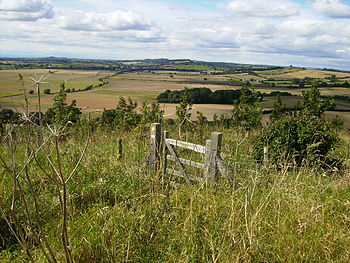
Created page with 'right|thumb|350px|On the Howardian Hills {{county|Yorkshire}} The '''Howardian Hills''' are a fine range of low, rolling hills in the [[North Riding …' |
m clean up, typos fixed: the the → the |
||
| Line 3: | Line 3: | ||
The '''Howardian Hills''' are a fine range of low, rolling hills in the [[North Riding of Yorkshire]], roughly rectangular in shape, running down to the [[River Derwent, Yorkshire|River Derwent]], which marks the boundary of the [[East Riding of Yorkshire|East Riding]]. | The '''Howardian Hills''' are a fine range of low, rolling hills in the [[North Riding of Yorkshire]], roughly rectangular in shape, running down to the [[River Derwent, Yorkshire|River Derwent]], which marks the boundary of the [[East Riding of Yorkshire|East Riding]]. | ||
The hills stand fairly distinctively on their own, with | The hills stand fairly distinctively on their own, with the [[Vale of York]] to the southwest and beyond them the [[Yorkshire Wolds]] and the [[North York Moors]]. The hills reach the banks of the Derwent at [[Huttons Ambo]]. The largest village is [[Terrington]], on the south slopes of the hills. | ||
It is a unique and captivating landscape with its well-wooded rolling countryside, patchwork of arable and pasture fields, scenic villages and historic country houses with classic parkland landscapes. Much of the range is part of the [[Castle Howard]] Estate, owned by the Howard family, after which the hills are named. | It is a unique and captivating landscape with its well-wooded rolling countryside, patchwork of arable and pasture fields, scenic villages and historic country houses with classic parkland landscapes. Much of the range is part of the [[Castle Howard]] Estate, owned by the Howard family, after which the hills are named. | ||
| Line 33: | Line 33: | ||
==Land use== | ==Land use== | ||
High grade arable land, pasture and managed woodland makes this rich farming country whose diversity creates its attractive rural character.<ref name=nateng> {{cite web|url=http://www.countryside.gov.uk/LAR/Landscape/DL/aonbs/aonb_howardianhills.asp |title=AONB Howardian Hills |accessdate=2008-05-20 |publisher=Natural England }}</ref><ref> {{cite web|url=http://www.howardianhills.org.uk/downloads/Facts.pdf |title=Facts |accessdate=2008-05-21 |format=pdf }}</ref> | High grade arable land, pasture and managed woodland makes this rich farming country whose diversity creates its attractive rural character.<ref name=nateng>{{cite web|url=http://www.countryside.gov.uk/LAR/Landscape/DL/aonbs/aonb_howardianhills.asp |title=AONB Howardian Hills |accessdate=2008-05-20 |publisher=Natural England }}</ref><ref>{{cite web|url=http://www.howardianhills.org.uk/downloads/Facts.pdf |title=Facts |accessdate=2008-05-21 |format=pdf }}</ref> | ||
==Outside links== | ==Outside links== | ||
Revision as of 17:06, 30 January 2016

The Howardian Hills are a fine range of low, rolling hills in the North Riding of Yorkshire, roughly rectangular in shape, running down to the River Derwent, which marks the boundary of the East Riding.
The hills stand fairly distinctively on their own, with the Vale of York to the southwest and beyond them the Yorkshire Wolds and the North York Moors. The hills reach the banks of the Derwent at Huttons Ambo. The largest village is Terrington, on the south slopes of the hills.
It is a unique and captivating landscape with its well-wooded rolling countryside, patchwork of arable and pasture fields, scenic villages and historic country houses with classic parkland landscapes. Much of the range is part of the Castle Howard Estate, owned by the Howard family, after which the hills are named.
The "Howardian Hills Area of Outstanding Natural Beauty" was designated in 1987.
Landscape
The Howardian Hills form a distinctive, roughly rectangular area of well-wooded undulating countryside rising, sometimes sharply, between the flat agricultural plains of Pickering and York.
Jurassic limestone gives the landscape its character and in effect, the irregular ridges of the Howardian Hills, rising to over 500 feet above sea level, are a southern extension of the rocks of the North York Moors. It contains a rich and intimate tapestry of wooded hills and valleys, pastures and rolling farmland, as well as dramatic views from the higher ground across the agricultural plains below.
On the eastern edge, the river Derwent cuts through the Hills in the Kirkham Gorge, a deep winding valley which was formed as an overflow channel from glacial Lake Pickering.
Combining high grade arable land, pasture and managed woodland, this is rich farming country whose very diversity creates its attractive rural character.
Area of Outstanding Natural Beauty

The Howardian Hills Area of Outstanding Natural Beauty was designated in 1987. It covers 79 square miles of rolling hills, woods, fields, pastures, fens, rivers and historic parkland, including an area across the Derwent in the East Riding of Yorkshire.
Within this distinctive landscape lie farms, scenic villages and some of the finest stately homes in the north including Castle Howard after which the area is named.
Villages
The hills have no towns, but many small villages. The market towns of Helmsley and Malton lie off the hills.
From Brandsby to Coneysthorpe is a line of spring line villages. The area has many attractive stone-built, red pantile-roofed buildings.
It is the setting for a number of fine country houses, whose parklands are an intrinsic part of the landscape. These grand houses and designed landscapes, such as Castle Howard, Newburgh Priory, Hovingham Hall, Gilling Castle and Nunnington Hall, have a dramatic effect upon the scene. The most notable of these is Vanbrugh's famous masterpiece, Castle Howard.
Land use
High grade arable land, pasture and managed woodland makes this rich farming country whose diversity creates its attractive rural character.[1][2]
Outside links
References
- ↑ "AONB Howardian Hills". Natural England. http://www.countryside.gov.uk/LAR/Landscape/DL/aonbs/aonb_howardianhills.asp. Retrieved 2008-05-20.
- ↑ "Facts" (pdf). http://www.howardianhills.org.uk/downloads/Facts.pdf. Retrieved 2008-05-21.
- Bateman, J. (2006) 'Howardian Hills Field Collection Survey' John Bateman: York Archaeological Survey Report.
- Ampleforth Parish Council Village partly in the Howardian Hills AONB
Coordinates: 54°08′23″N 1°00′24″W / 54.13974°N 1.00656°W