Gare Loch: Difference between revisions
Created page with "right|thumb|300px|Faslane Naval Base in Gair Loch '''Gare Loch''' or '''Gareloch''' is a sea loch in Dunbartonshir..." |
No edit summary |
||
| Line 1: | Line 1: | ||
{{For|the similarly-named loch in Ross-shire|Gair Loch}} | |||
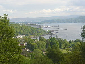
[[File:Faslane Naval Base - geograph.org.uk - 180802.jpg|right|thumb|300px|Faslane Naval Base in Gair Loch]] | [[File:Faslane Naval Base - geograph.org.uk - 180802.jpg|right|thumb|300px|Faslane Naval Base in Gair Loch]] | ||
'''Gare Loch''' or '''Gareloch''' is a sea loch in [[Dunbartonshire]], in the very west of the county, separating the Rosneath peninsula from the body of the county. It opens into the [[Firth of Clyde]] by [[Helensburgh]]. | '''Gare Loch''' or '''Gareloch''' is a sea loch in [[Dunbartonshire]], in the very west of the county, separating the Rosneath peninsula from the body of the county. It opens into the [[Firth of Clyde]] by [[Helensburgh]]. | ||
Revision as of 09:11, 12 June 2015

Gare Loch or Gareloch is a sea loch in Dunbartonshire, in the very west of the county, separating the Rosneath peninsula from the body of the county. It opens into the Firth of Clyde by Helensburgh.
Geography
A sea loch aligned north-south, Gare Loch is 7 miles long. At its southern end it opens into the Firth of Clyde through the Rhu narrows. The village of Rosneath lies on the western shore just north of Rosneath Point and gives the name Rosneath Peninsula to the whole body of land separating the Gare Loch from Loch Long to the west.
At the head of the loch is the village of Garelochhead.
The town of Helensburgh lies on the eastern shore, giving attractive views across to Rosneath Point. Rhu, to the north of Helensburgh, features a yacht marina.
Further north, the eastern shore is dominated by the Faslane Naval Base, the home of the United Kingdom's Trident nuclear submarines. The loch was the site of a major naval base during the Second World War and was used to store decommissioned naval vessels in the 1950s. A shipbreakers yard ceased trading in the 1980s and has been absorbed into the naval base.
At the north end of the loch the substantial village of Garelochhead includes adventure holiday facilities and has a station on the West Highland Line. Garelochhead is used as a Royal Marine training centre. The Gare Loch offers good conditions for sightseeing, sailing and sea angling. The Greek sugar boat Captayannis was heading for the sheltered waters of the Loch but now lies wrecked in the Clyde.
| <slippymap lat="56.036667" lon="-4.8" z="4" w="250" h="300" layer="colour"/> |
Outside links
| ("Wikimedia Commons" has material about Gare Loch) |
- Map showing 'Gherr Loch', circa 1600, National Library of Scotland
