Cockfosters: Difference between revisions
Jump to navigation
Jump to search
No edit summary |
No edit summary |
||
| Line 1: | Line 1: | ||
{{Infobox town | {{Infobox town | ||
|name=Cockfosters | |name=Cockfosters | ||
|county=Hertfordshire | |county 1=Hertfordshire | ||
|county 2=Middlesex | |||
|picture = Cockfosters_Underground_Station_-_geograph.org.uk_-_1065123.jpg | |picture = Cockfosters_Underground_Station_-_geograph.org.uk_-_1065123.jpg | ||
|picture caption=Cockfosters tube station | |picture caption=Cockfosters tube station | ||
| Line 16: | Line 17: | ||
{{stub}} | {{stub}} | ||
{{stub|Middlesex}} | |||
Revision as of 22:35, 14 May 2014
| Cockfosters | |
| Hertfordshire, Middlesex | |
|---|---|
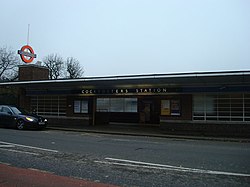
 Cockfosters tube station | |
| Location | |
| Grid reference: | TQ275965 |
| Location: | 51°39’10"N, 0°9’22"W |
| Data | |
| Post town: | BARNET |
| Postcode: | EN4 |
| Dialling code: | 020 |
| Local Government | |
| Council: | Barnet / Enfield |
| Parliamentary constituency: |
Chipping Barnet Enfield Southgate |
Cockfosters is a town straddling the border between Hertfordshire and Middlesex. It is at the far northern end of the London conurbation, bordering Barnet to the south and west, and open country to the north and east. Cockfosters is most famous for its tube station being the northern terminus of the Piccadilly line of the London Underground.

This Hertfordshire article is a stub: help to improve Wikishire by building it up.

This Middlesex article is a stub: help to improve Wikishire by building it up.