South Killingholme: Difference between revisions
Created page with '{{Infobox town |name=South Killingholme |county=Lincolnshire |picture=South Killingholme - geograph.org.uk - 389725.jpg |picture caption=South Killingholme village |os grid ref=…' |
|||
| Line 22: | Line 22: | ||
The village is between [[Grimsby]] and [[Scunthorpe]]; slightly closer to the former. | The village is between [[Grimsby]] and [[Scunthorpe]]; slightly closer to the former. | ||
The parish lies between [[North Killingholme]] to the north, [[Ulceby]] to the west, [[Brocklesby]] to the south-west, and [[Habrough]] and [[Immingham]] to the south. The parish includes the Humber Refinery, the Immingham Power Station, the Immingham Coal Terminal, the Humber International Terminal (built in 2002), most of the Associated Petroleum Terminals, Immingham Ore Terminal, and the south-east corner of the Lindsey Oil Refinery. | The parish lies between [[North Killingholme]] to the north, [[Ulceby, North Riding of Lindsey|Ulceby]] to the west, [[Brocklesby]] to the south-west, and [[Habrough]] and [[Immingham]] to the south. The parish includes the Humber Refinery, the Immingham Power Station, the Immingham Coal Terminal, the Humber International Terminal (built in 2002), most of the Associated Petroleum Terminals, Immingham Ore Terminal, and the south-east corner of the Lindsey Oil Refinery. | ||
The division between North and South Killingholme is the Eastfield Road railway bridge and West Middle Mere Road. The village is more heavily populated then North Killingholme. | The division between North and South Killingholme is the Eastfield Road railway bridge and West Middle Mere Road. The village is more heavily populated then North Killingholme. | ||
Latest revision as of 23:30, 24 November 2020
| South Killingholme | |
| Lincolnshire | |
|---|---|
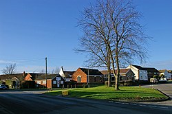
 South Killingholme village | |
| Location | |
| Grid reference: | TA178145 |
| Location: | 53°37’55"N, 0°14’14"W |
| Data | |
| Population: | 1,048 (2001) |
| Post town: | Immingham |
| Postcode: | DN40 |
| Dialling code: | 01469 |
| Local Government | |
| Council: | North Lincolnshire |
| Parliamentary constituency: |
Cleethorpes |
South Killingholme is a village in Lincolnshire, on the coast of the Humber estuary in Lindsey. It is divided by the A160 dual carriageway. Considerably larger than its neighbour, North Killingholme, together they make up the area of Killingholme.
South Killingholme is an industrial village, dominated by the refineries, themselves fed by the ships entering the Humber.
Geography
The village is between Grimsby and Scunthorpe; slightly closer to the former.
The parish lies between North Killingholme to the north, Ulceby to the west, Brocklesby to the south-west, and Habrough and Immingham to the south. The parish includes the Humber Refinery, the Immingham Power Station, the Immingham Coal Terminal, the Humber International Terminal (built in 2002), most of the Associated Petroleum Terminals, Immingham Ore Terminal, and the south-east corner of the Lindsey Oil Refinery.
The division between North and South Killingholme is the Eastfield Road railway bridge and West Middle Mere Road. The village is more heavily populated then North Killingholme.
The village
The village has a fair range of village facilities; village shop, a doctor's surgery, hairdresser, primary school, community centre, bowling green, park, chip shop and a sandwich shop.
The one public house is "the Cross Keys".
The village also holds an annual village fete with guest appearances.
The village was featured on a programme produced for Sky One, The Toughest Villages in Britain in 2003.
Refineries

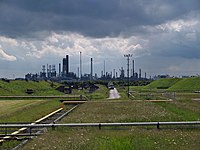
The Humber Refinery[1] and Lindsey Oil Refinery dramatically dominate the skyline around the village and there is some local opposition to their presence, particularly since a large explosion occurred at the Humber Refinery in 2001.
Large traffic increases at the time of refinery workers travelling to and from work forced one of the village's roads to be converted into a one way system. The problem remains unresolved at North Killingholme.
ConocoPhillips runs a gala every August as a part of its community relations policy and has given money to local projects, such as a new playground for the school and refurbishing a roundabout on the dual carriageway.
Big Society
Community centre
South Killingholme Community Centre is a medium-sized facility in the village which hosts many activities, and has a bowling green, football pitch and tennis court. Its adjacent field hosts the annual Killingholme Gala, sponsored by neighbouring oil refinery owners ConocoPhillips. Much of the building is an auditorium and theatre, which has hosted live music, discos and bingo.
Mayflower Wood
Conoco Phillips were also responsible for the development of Mayflower Wood, a 120-acre community woodland just outside the village. Planting started in 2005 and over two years over 67,000 trees and shrubs were planted.[2]
See also
References
- ↑ Humber Refinery - Information on the ConocoPhillips website
- ↑ http://www.mayflowerwood.co.uk/index.html Mayflower Wood
Outside links
| ("Wikimedia Commons" has material about South Killingholme) |
