Foyn Coast: Difference between revisions
Jump to navigation
Jump to search
No edit summary |
|||
| Line 1: | Line 1: | ||
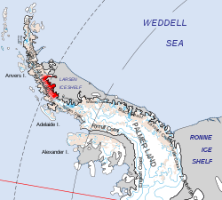
[[File:Foyn Coast.svg|right|thumb|250px|Location of the Foyn Coast]] | |||
{{territory|BAT}} | {{territory|BAT}} | ||
The '''Foyn Coast''' is that portion of the east coast of the [[Antarctic Peninsula]] between [[Cape Alexander]] and [[Cape Northrop]]. | The '''Foyn Coast''' is that portion of the east coast of the [[Antarctic Peninsula]] between [[Cape Alexander]] and [[Cape Northrop]]. | ||
Latest revision as of 20:47, 19 July 2020

The Foyn Coast is that portion of the east coast of the Antarctic Peninsula between Cape Alexander and Cape Northrop.
The coast was discovered in 1893 by a Norwegian expedition under Captain Carl Anton Larsen, who named it for Svend Foyn, a Norwegian whaler of Tønsberg whose invention of the grenade harpoon greatly facilitated modern whaling.
Location
- Location map: 66°39’58"S, 64°19’59"W
References
- Gazetteer and Map of The British Antarctic Territory: Foyn Coast
| Coasts of the British Antarctic Territory | |||
|---|---|---|---|
| Trinity Peninsula |
Graham Land: Nordenskjöld • Oscar II • Foyn • Bowman • Palmer Land: Wilkins • Black • Lassiter • Orville • Zumberge |
||
|
Graham Land: Davis • Danco • Graham • Loubet • Fallières • Palmer Land: Rymill • English |
|||