Culkein: Difference between revisions
Jump to navigation
Jump to search
Created page with "{{Infobox town |name=Culkein Stoer |gaelic=An Cùl-cinn |county=Sutherland |picture=Culkein Bay - geograph.org.uk - 449387.jpg |picture caption=Culkein Bay |os grid ref=NC0383..." |
|||
| Line 21: | Line 21: | ||
==See also== | ==See also== | ||
*[[Stoer Head]] | *[[Stoer Head]] | ||
*[[Bay of Culkein]] | |||
*[[Culkein Drumbeg]] | *[[Culkein Drumbeg]] | ||
==References== | ==References== | ||
{{reflist}} | {{reflist}} | ||
Latest revision as of 17:55, 4 March 2019
| Culkein Stoer Gaelic: An Cùl-cinn | |
| Sutherland | |
|---|---|
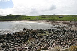
 Culkein Bay | |
| Location | |
| Grid reference: | NC038325 |
| Location: | 58°14’16"N, 5°20’37"W |
| Data | |
| Post town: | Lairg |
| Postcode: | IV27 4 |
| Local Government | |
| Council: | Highland |
Culkein (also known as Culkein Stoer in order to distinguish it from Culkein Drumbeg up the coast), is a remote, former fishing village, centred on the Bay of Culkein on the west coast of Sutherland. It is found on the north-east coast of the Stoer Head peninsula, in the Assynt area of Sutherland.
The Old Man of Stoer is directly accessible from Culkein, being approximately half a mile north-west of Culkein.[1]