Allerdale below Derwent Ward: Difference between revisions
Jump to navigation
Jump to search
No edit summary |
mNo edit summary |
||
| Line 12: | Line 12: | ||
*[[Bromfield, Cumberland|Bromfield]] (part)<sup>*</sup> | *[[Bromfield, Cumberland|Bromfield]] (part)<sup>*</sup> | ||
*[[Caldbeck]] (part)<sup>†</sup> | *[[Caldbeck]] (part)<sup>†</sup> | ||
*[[Camerton]] | *[[Camerton, Cumberland|Camerton]] | ||
*[[Crosthwaite, Cumberland|Crosthwaite]] (part)<sup>‡</sup> | *[[Crosthwaite, Cumberland|Crosthwaite]] (part)<sup>‡</sup> | ||
*[[Crosscanonby]] | *[[Crosscanonby]] | ||
Latest revision as of 19:28, 24 March 2021

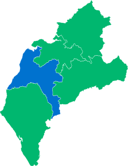
Allerdale below Derwent Ward is one of the wards of Cumberland. It is situated in the centre of the county, bounded to the north-east by Cumberland Ward; to the south-east by Leath Ward; to the south-west by Allerdale above Derwent Ward; and to the west by the Solway Firth.
The hundred comprises the ancient parishes of:
- Allhallows
- Aspatria
- Bassenthwaite
- Bolton
- Bridekirk
- Bromfield (part)*
- Caldbeck (part)†
- Camerton
- Crosthwaite (part)‡
- Crosscanonby
- Dearham
- Flimby
- Gilcrux
- Holme Cultram
- Ireby
- Isel
- Plumbland
- Skiddaw Forest (ex. par.)
- Torpenhow
- Uldale
- Westward (part)§
*: Townships of Blencogo and Dundraw, Kelsick and Wheyrigg in Cumberland Ward.
†: Township of Mosedale in Leath Ward.
‡: Townships of Briery, Keswick, Underskiddaw, and St Johns Castlerigg and Wythburn.
§: Township of Woodside in Cumberland Ward.
The ward had a population of 45,334 in 2011.
| Wards of Cumberland |
|---|
|
Allerdale above Derwent • Allerdale below Derwent • Cumberland • Eskdale • Leath |