Camerton, Cumberland
| Camerton | |
| Cumberland | |
|---|---|
 Camerton Hall | |
| Location | |
| Grid reference: | NY037312 |
| Location: | 54°39’50"N, 3°29’42"W |
| Data | |
| Population: | 174 (2011) |
| Post town: | Workington |
| Postcode: | CA14 |
| Dialling code: | 01900 |
| Local Government | |
| Council: | Cumberland |
| Parliamentary constituency: |
Workington |
Camerton is a small village in the west of Cumberland, close to the Irish Sea coast. The village dates back at least to the Middle Ages. The population was recorded at 172 in the 2011 census.
The village stands about a mile north-east of Seaton, to which it is linked by road; close by too are Great Broughton and Flimby.
There used to be a small footbridge over the river to Great Clifton however this was destroyed by the floods of November 2009.
Name
The origin of the name 'Camerton' is obscure. The latter element is the Old English tun, menaing 'village'. The first element in the name might be a personal name ("possibly 'Cafmær') or otherwise the Old Welsh cym(m)er ('confluence') has been proposed: that might refer to nearby stream and river, "but the phonology would offer difficulties, and the stream running into the Derwent is insignificant."[1] So, the name means perhaps 'Cafmær's village', or 'the village by the meeting of waters'.
St Peter's church
St Peter's church is located south-east of the village on a meander of the River Derwent. The church building partly dates from the mid-19th century, but "parts of the structure could be mediæval, for instance, the transept arch with its step and chamfer." [2]
The church contains the tomb of 'Black Tom', an old 'lord' of Camerton. According to local legend, Black Tom's ghost haunts the churchyard. Black Tom is also the name of the village pub.
Railways
Two railway lines once served Camerton. The line and railway station in the valley bottom were built by the Cockermouth and Workington Railway (CWR) which was eventually extended eastwards to Penrith, giving national connections and even the "Lakes Express", a through train to Euston Station, London, though this passed straight through Camerton. The station closed in 1952 and the line in 1966. In 2013 the station master's house was still in use as a private residence. The former railway embankment could still be seen, but the supports and pier of the former bridge over the river were washed away during the 2009 Workington floods, leaving no trace.
A second line ran on higher ground to the north of the village, this was the Cleator and Workington Junction Railway's (C&WJR) "Northern Extension" which was part of a wider venture to connect west Cumbrian ironworks with Scotland. Camerton never had a public station on that line, the nearest being at Seaton and Great Broughton, though their lives as passenger stations were very short. Although this line lost its meagre passenger services past Camerton as early as 1908 and was closed and lifted north of Buckhill Colliery in the 1930s, trains still passed Camerton along it until 1992 to serve the naval armaments depot at Broughton.
Collieries
Camerton once had two pits, both of which mined both coal and clay. Camerton No. 2 Colliery was north of the village next to the C&WJR line where an unadvertised workmen's halt was provided; Camerton Colliery Halt. This colliery appears to have been abandoned in 1908.
Camerton No. 1 Colliery was next to the River Derwent. It was connected to the CWR line. It is unclear when it was abandoned.[3]
Both pits had associated brickworks.
Walking
There are good walking opportunities in the area including the nearby Scaw Bank wood.
-
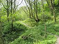 Scaw Bank Wood, Camerton
 -
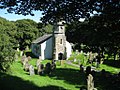 St Peter's Church, Camerton


Outside links
| ("Wikimedia Commons" has material about Camerton, Cumberland) |
- The village, railways, river and collieries c1908, via National Library of Scotland
- The village, railways, river and collieries in 1948, via npe maps
- St Peter's church
- Camerton Hall
References
- ↑ Armstrong, A. M.; Mawer, A.; Stenton, F. M.; Dickens, B. (1950). The place-names of Cumberland. English Place-Name Society, vol.xxi. Part 2. Cambridge: Cambridge University Press. pp. 281–82.
- ↑ Nikolaus Pevsner: The Buildings of England: Cumberland and Westmorland, 1967 Penguin Books
- ↑ Camerton Collieries, via Durham Mining Museum