Amlwch: Difference between revisions
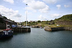
Created page with '{{infobox town |name=Amlwch |county=Anglesey |picture=Amlwch harbour Anglesey - geograph.org.uk - 38833.jpg |piture caption=Amlwch Harbour |latitude= 53.41 |longitude=-04.34 |os …' |
No edit summary |
||
| Line 15: | Line 15: | ||
|census year=2001 | |census year=2001 | ||
}} | }} | ||
'''Amlwch''' is a small town on the northern coast of the Isle of [[Anglesey]]. It is the most northerly town in [[Wales]]. | '''Amlwch''' is a small town on the northern coast of the Isle of [[Anglesey]]. It is the most northerly town in [[Wales]]. | ||
| Line 35: | Line 34: | ||
{{reflist}} | {{reflist}} | ||
== | ==Outside links== | ||
*[http://y2u.co.uk/&002_Images/Parys_Mountain_01.htm Photos of the Parys Mountain Copper Mine near Amlwch] | *[http://y2u.co.uk/&002_Images/Parys_Mountain_01.htm Photos of the Parys Mountain Copper Mine near Amlwch] | ||
*[http://www.parysmountain.co.uk History of Copper mining at Parys Mountain] | *[http://www.parysmountain.co.uk History of Copper mining at Parys Mountain] | ||
Revision as of 14:21, 11 October 2010
| Amlwch | |
| Anglesey | |
|---|---|

| |
| Location | |
| Grid reference: | SH439930 |
| Location: | 53°24’36"N, 4°20’24"W |
| Data | |
| Population: | 3,438 (2001) |
| Postcode: | LL68 |
| Dialling code: | 01407 |
| Local Government | |
| Council: | Anglesey |
Amlwch is a small town on the northern coast of the Isle of Anglesey. It is the most northerly town in Wales.
The town has an active fishing harbour. It has no beach, but is set amongst it has impressive seacliffs. Tourism is an important element of the local economy. At one time Amlwch was a busy port, with boats sailing to the Isle of Man and to Liverpool. A number of the houses date from the 19th century and add to the atmosphere of the town.
The name Amlwch derives is Welsh for "around the inlet or creek".[1]
According to legend in the Middle Ages, the town developed on a site that had a harbour but was not visible from the sea, which helped to reduce the chance of Viking attacks. Amlwch grew rapidly in the 18th century near what was then the world's biggest copper mine at the nearby Parys Mountain. By the late 18th century, Amlwch had a population of around 10,000 and was the largest town in Wales after Merthyr Tydfil. It was at this time that its harbour was also extended to accommodate the ships needed to transport the ore. It is currently the fourth largest settlement on the island with 3,438 inhabitants.
When copper mining began to decline in the mid 1850s, shipbuilding became the main industry with many people also becoming involved in the ship repair and other maritime industries. Even after the decline of the copper mine some chemical industries remained and in 1953 a chemical plant was built to extract bromine from sea water for use in petrol engines, but this closed in 2004. The imminent closure of nearby Wylfa Nuclear Power Station will have a further detrimental effect on the local economy.
At the peak of the copper mining, it is believed that Amlwch had a record ratio of one public house to every four people. Today there are far fewer, but a number of busy pubs remain.
Until the line closed in 1993, Amlwch was formerly the northern terminus of the Anglesey Central Railway.
Attractions in Amlwch include its restored port, the Anglesey Coastal Path which passes through it, its watch tower containing a small heritage centre, St Eleth's Church, Amlwch (which dates from 1800) and the reinforced concrete Catholic church Our Lady Star of the Sea and St Winefride, built in 1937. The town's leisure centre is one of the few on Anglesey and has a swimming pool, sports centre and squash courts.