Murton, Westmorland: Difference between revisions
Jump to navigation
Jump to search
Created page with "{{Infobox town |name=Murton |county=Westmorland |picture=Hilton_-_geograph.org.uk - 19141.jpg |picture caption=Murton Pike |os grid ref=NY726213 |latitude=54.586779 |longitude..." |
mNo edit summary |
||
| Line 15: | Line 15: | ||
|constituency=Penrith and The Border | |constituency=Penrith and The Border | ||
}} | }} | ||
'''Murton''' is a small [[Westmorland]] village – a little place with a population recorded as just 360 in the 2011 Census. There is a wider civil parish of Murton too, which encompasses | '''Murton''' is a small [[Westmorland]] village – a little place with a population recorded as just 360 in the 2011 Census. There is a wider civil parish of Murton too, which encompasses Murton itself, [[Hilton, Westmorland|Hilton]], [[Langton, Westmorland|Langton]], and [[Brackenber]]. The county town, [[Appleby-in-Westmorland]] is to the south-west. | ||
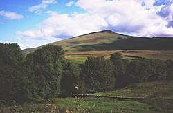
Murton Pike, to the north of the village, ({{wmap|54.602052|-2.411299|zoom=14}}) is 1,949 feet high and is topped by a triangulation point; it is a south-westerly outlier of [[Murton Fell]], which rises to over 2,198 feet at two points. Parts of Murton Fell lie within the Army's Warcop Training Area.<ref>Walking in the North Pennines , Paddy Dillon , 1991 , "Warcop Range Section" , pp.71–82 [https://books.google.com/books?id=5hzwJLFEHYoC&lpg=PA71&ots=__q13uCztR&dq=murton%20fell&pg=PA71#v=onepage&q=murton%20fell&f=false google books preview]</ref> | Murton Pike, to the north of the village, ({{wmap|54.602052|-2.411299|zoom=14}}) is 1,949 feet high and is topped by a triangulation point; it is a south-westerly outlier of [[Murton Fell]], which rises to over 2,198 feet at two points. Parts of Murton Fell lie within the Army's Warcop Training Area.<ref>Walking in the North Pennines , Paddy Dillon , 1991 , "Warcop Range Section" , pp.71–82 [https://books.google.com/books?id=5hzwJLFEHYoC&lpg=PA71&ots=__q13uCztR&dq=murton%20fell&pg=PA71#v=onepage&q=murton%20fell&f=false google books preview]</ref> | ||
Latest revision as of 06:26, 15 September 2017
| Murton | |
| Westmorland | |
|---|---|
 Murton Pike | |
| Location | |
| Grid reference: | NY726213 |
| Location: | 54°35’12"N, 2°25’30"W |
| Data | |
| Population: | 360 (2011) |
| Post town: | Appleby In Westmorland |
| Postcode: | CA16 |
| Dialling code: | 01768 |
| Local Government | |
| Council: | Westmorland & Furness |
| Parliamentary constituency: |
Penrith and The Border |
Murton is a small Westmorland village – a little place with a population recorded as just 360 in the 2011 Census. There is a wider civil parish of Murton too, which encompasses Murton itself, Hilton, Langton, and Brackenber. The county town, Appleby-in-Westmorland is to the south-west.
Murton Pike, to the north of the village, (54°36’7"N, 2°24’41"W) is 1,949 feet high and is topped by a triangulation point; it is a south-westerly outlier of Murton Fell, which rises to over 2,198 feet at two points. Parts of Murton Fell lie within the Army's Warcop Training Area.[1]
Outside links
| ("Wikimedia Commons" has material about Murton, Westmorland) |
References
- ↑ Walking in the North Pennines , Paddy Dillon , 1991 , "Warcop Range Section" , pp.71–82 google books preview
