Lowestoft Ness: Difference between revisions
Jump to navigation
Jump to search
Created page with "right|thumb|270px|Euroscope, Ness Point {{county|Suffolk}} '''Lowestoft Ness''', also known as '''Ness Point''',..." |
|||
| Line 11: | Line 11: | ||
**[[Corrachadh Mòr]], westernmost of mainland Great Britain | **[[Corrachadh Mòr]], westernmost of mainland Great Britain | ||
*Southernmost points: | *Southernmost points: | ||
*[[Western Rocks, Isles of Scilly]], southernmost of the United Kingdom | **[[Western Rocks, Isles of Scilly]], southernmost of the United Kingdom | ||
*[[Lizard Point]], southernmost of mainland Great Britain | **[[Lizard Point]], southernmost of mainland Great Britain | ||
*Northernmost points: | *Northernmost points: | ||
**[[Out Stack]], northernmost of the United Kingdom | **[[Out Stack]], northernmost of the United Kingdom | ||
Latest revision as of 22:51, 8 November 2016

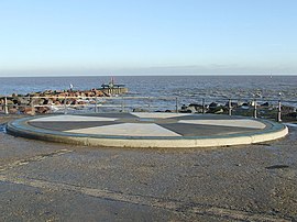
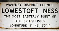
Lowestoft Ness, also known as Ness Point, is the most easterly point of the United Kingdom and of the British Isles. It is barely a headland but a small bump in Suffolk's smooth coast, and is found in Lowestoft in Suffolk. A little to the north of the town centre and today it has a direction marker, known as Euroscope, marking locations in other countries and how far away they are from the Ness.[1]

Ness point is the site for the Orbis Energy Centre, a renewable energy development centre. Also located at Ness Point is Britain's tallest wind turbine, nicknamed "Gulliver". It stands 413 feet tall, generating energy for the National Grid.[2]
See also
- Westernmost points:
- Rockall, westernmost of the United Kingdom
- Corrachadh Mòr, westernmost of mainland Great Britain
- Southernmost points:
- Western Rocks, Isles of Scilly, southernmost of the United Kingdom
- Lizard Point, southernmost of mainland Great Britain
- Northernmost points:
- Out Stack, northernmost of the United Kingdom
- Dunnet Head, northernmost of mainland Great Britain
Outside links
- Location map: 52°28’52"N, 1°45’46"W
- Ness Point
References
- ↑ The mess that is Ness, BBC Suffolk, 2008. Retrieved 2011-04-21.
- ↑ Suffolk's first turbine, BBC Suffolk, 2007. Retrieved 2011-04-21.