East Barnet: Difference between revisions
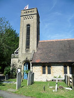
Created page with "{{infobox town |county=Hertfordshire |picture=St Mary the Virgin church, East Barnet 02.JPG |picture caption=St Mary the Virgin parish church |official_name= East Barnet |lati..." |
No edit summary |
||
| Line 13: | Line 13: | ||
|os grid ref=TQ271954 | |os grid ref=TQ271954 | ||
}} | }} | ||
'''East Barnet''' is an ancient parish in southern [[Hertfordshire]] that forms part of the metropolitan conurbation. It is bordered by [[New Barnet]] to the north; and on all other sides by [[Middlesex]]: [[Cockfosters]] to the east; [[Southgate]] to the south; and [[Whetstone]] to the west. It is a largely residential suburb whose central area contains shops, public houses, restaurants and services, and the parish church of St Mary the Virgin. East Barnet is close to the [[M25 motorway|M25]] and the A1 and [[M1 motorway|M1]]. | '''East Barnet''' is an ancient parish in southern [[Hertfordshire]] that forms part of the metropolitan conurbation. It is bordered by [[New Barnet]] to the north; and on all other sides by [[Middlesex]]: [[Cockfosters]] to the east; [[Southgate, Middlesex|Southgate]] to the south; and [[Whetstone]] to the west. It is a largely residential suburb whose central area contains shops, public houses, restaurants and services, and the parish church of St Mary the Virgin. East Barnet is close to the [[M25 motorway|M25]] and the A1 and [[M1 motorway|M1]]. | ||
==Transport== | ==Transport== | ||
Latest revision as of 15:36, 19 October 2016
| East Barnet | |
| Hertfordshire | |
|---|---|
 St Mary the Virgin parish church | |
| Location | |
| Grid reference: | TQ271954 |
| Location: | 51°38’35"N, 0°9’47"W |
| Data | |
| Post town: | Barnet |
| Postcode: | EN4 |
| Dialling code: | 020 |
| Local Government | |
| Council: | Barnet |
| Parliamentary constituency: |
Chipping Barnet |
East Barnet is an ancient parish in southern Hertfordshire that forms part of the metropolitan conurbation. It is bordered by New Barnet to the north; and on all other sides by Middlesex: Cockfosters to the east; Southgate to the south; and Whetstone to the west. It is a largely residential suburb whose central area contains shops, public houses, restaurants and services, and the parish church of St Mary the Virgin. East Barnet is close to the M25 and the A1 and M1.
Transport
- Railway stations nearby
- Oakleigh Park
- New Barnet
- Tube stations nearby
- Cockfosters - Piccadilly line
- Oakwood - Piccadilly line
- High Barnet - Northern line
- Totteridge & Whetstone - Northern line
Theatre and the Arts
Bodens Performing Arts School, aka Bodens, is located in East Barnet. It was founded in 1973 in Enfield, and has since moved to its current site. It is a performing arts school offering Arts education to children and teenagers from the ages of 3 to 18. The Studios are located on East Barnet Road, along with the 'Tony Boden Theatre' which is on premises.
Outside links
| ("Wikimedia Commons" has material about East Barnet) |
