River Ottery: Difference between revisions
No edit summary |
|||
| Line 1: | Line 1: | ||
{{county|Devon}} | |||
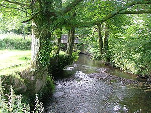
[[File:River Ottery - geograph.org.uk - 212774.jpg|right|thumb|300px|The Ottery at Canworthy Water]] | [[File:River Ottery - geograph.org.uk - 212774.jpg|right|thumb|300px|The Ottery at Canworthy Water]] | ||
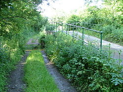
[[File:Trengune - geograph.org.uk - 210786.jpg|right|thumb|250px|Ford and bridge at Trengune]] | [[File:Trengune - geograph.org.uk - 210786.jpg|right|thumb|250px|Ford and bridge at Trengune]] | ||
| Line 4: | Line 5: | ||
The '''River Ottery''' is a small river, a tributary of the [[River Tamar]], which marks the boundary between [[Cornwall]] and [[Devon]]. It is an unusual part of the county boundary, lying west of the Tamar, for the border between the two counties for the most part follows the Tamar almost from coast to coast, but as the Ottery meets the Tamar, the border follows the Ottery for several miles before returning to the Tamar, the resultant finger of Devon west of the Tamar being almost a detached part, isolated from its county by a stretch of the Tamar crossed only by a narrow, isolated bridge. | The '''River Ottery''' is a small river, a tributary of the [[River Tamar]], which marks the boundary between [[Cornwall]] and [[Devon]]. It is an unusual part of the county boundary, lying west of the Tamar, for the border between the two counties for the most part follows the Tamar almost from coast to coast, but as the Ottery meets the Tamar, the border follows the Ottery for several miles before returning to the Tamar, the resultant finger of Devon west of the Tamar being almost a detached part, isolated from its county by a stretch of the Tamar crossed only by a narrow, isolated bridge. | ||
The Ottery is about twenty miles long from its source | The Ottery is about twenty miles long from its source south-east of [[Otterham]] to its meeting with the [[River Tamar]] at [[Nether Bridge]], two miles north-east of [[Launceston]]. | ||
==Hydrology and course== | ==Hydrology and course== | ||
With its tributaries | With its tributaries, the River Ottery forms a major sub-catchment of the Tamar system, draining 48 square miles of north Cornwall and detached Devon. The River Ottery's basin is within the carboniferous geological formation known as the Culm Measures which stretch from [[Dartmoor]] to north Devon and across north-east Cornwall as far west as [[Bodmin Moor]].<ref>[http://www.cornwallriversproject.org.uk/geography/ottery.htm] CornwallRivers Project. Retrieved April 2010</ref><ref>[http://www.english-nature.org.uk] English Nature website. Retrieved April 2010</ref> | ||
The infant river initially flows north until it reaches the hamlet of [[Trengune]]. From here it adopts an east- | The infant river initially flows north until it reaches the hamlet of [[Trengune]]. From here it adopts an east-south-easterly course which it follows to its confluence with the River Tamar. | ||
The largest tributaries to the River Ottery are Caudworthy Water and Bolsbridge Water which join the River Ottery from the north and Canworthy Water which joins from the south. | The largest tributaries to the River Ottery are Caudworthy Water and Bolsbridge Water which join the River Ottery from the north and Canworthy Water which joins from the south. | ||
| Line 18: | Line 19: | ||
==Wildlife and conservation== | ==Wildlife and conservation== | ||
The Cornwall Rivers Project notes five "Sites of Special Scientific Interest" in the Ottery catchment including the ''Ottery Valley SSSI'' which has | The Cornwall Rivers Project notes five "Sites of Special Scientific Interest" in the Ottery catchment including the ''Ottery Valley SSSI'' which has 82 acres of increasingly threatened culm habitat and ''Kernick and Ottery Meadows SSSI'', also noted for its biological interest.<ref>{{cite web|title=Ottery Valley|url=http://www.sssi.naturalengland.org.uk/citation/citation_photo/1000655.pdf|publisher=Natural England|accessdate=2 November 2011|year=1994}}</ref><ref>{{cite web|title=Kernick and Ottery Meadows|url=http://www.sssi.naturalengland.org.uk/citation/citation_photo/1006533.pdf|publisher=Natural England|accessdate=2 November 2011|year=1992}}</ref> | ||
The Project's page also notes: ''The Ottery supports a broad range of wildlife including populations of trout and migratory fish, otters, kingfishers, sand martins, dippers, curlews, snipe and the marsh fritillary butterfly.'' <ref>[http://www.cornwallriversproject.org.uk/geography/ottery.htm] CornwallRivers Project. Retrieved April 2010</ref> | The Project's page also notes: ''The Ottery supports a broad range of wildlife including populations of trout and migratory fish, otters, kingfishers, sand martins, dippers, curlews, snipe and the marsh fritillary butterfly.'' <ref>[http://www.cornwallriversproject.org.uk/geography/ottery.htm] CornwallRivers Project. Retrieved April 2010</ref> | ||
| Line 38: | Line 39: | ||
==Location== | ==Location== | ||
*Source coordinates {{ | *Source coordinates {{wmap|50.67944|-4.59460|zoom=14|name=Source of the Ottery}} {{map|SX 166 900}} | ||
*[[Trengune]] (change of course) coordinates {{ | *[[Trengune]] (change of course) coordinates {{wmap|50.71032|-4.56602|zoom=14}} {{map|SX 189 932}} | ||
*[[Canworthy Water]] (settlement) coordinates {{ | *[[Canworthy Water]] (settlement) coordinates {{wmap|50.69744|-4.51693|zoom=14}} {{map|SX 225 916}} | ||
*[[Yeolmbridge]] (settlement) coordinates {{ | *[[Yeolmbridge]] (settlement) coordinates {{wmap|50.66203|-4.38123|zoom=14}} {{map|SX 317 874}} | ||
*Confluence with [[River Tamar]] coordinates {{ | *Confluence with [[River Tamar]] coordinates {{wmap|50.65828|-4.33969|zoom=14|name=Confluence with Tamar}} {{map|SX 346 869}} | ||
==References== | ==References== | ||
Latest revision as of 19:29, 20 January 2018


The River Ottery is a small river, a tributary of the River Tamar, which marks the boundary between Cornwall and Devon. It is an unusual part of the county boundary, lying west of the Tamar, for the border between the two counties for the most part follows the Tamar almost from coast to coast, but as the Ottery meets the Tamar, the border follows the Ottery for several miles before returning to the Tamar, the resultant finger of Devon west of the Tamar being almost a detached part, isolated from its county by a stretch of the Tamar crossed only by a narrow, isolated bridge.
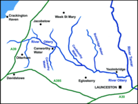
The Ottery is about twenty miles long from its source south-east of Otterham to its meeting with the River Tamar at Nether Bridge, two miles north-east of Launceston.
Hydrology and course
With its tributaries, the River Ottery forms a major sub-catchment of the Tamar system, draining 48 square miles of north Cornwall and detached Devon. The River Ottery's basin is within the carboniferous geological formation known as the Culm Measures which stretch from Dartmoor to north Devon and across north-east Cornwall as far west as Bodmin Moor.[1][2]
The infant river initially flows north until it reaches the hamlet of Trengune. From here it adopts an east-south-easterly course which it follows to its confluence with the River Tamar.
The largest tributaries to the River Ottery are Caudworthy Water and Bolsbridge Water which join the River Ottery from the north and Canworthy Water which joins from the south.
The River Ottery system was severely affected by flooding in north Cornwall on 16 August 2004 when up to eight inches of rain fell during a single afternoon.[3] The Ottery headwaters at Marshgate and Otterham were the most severely affected.
The river flows through an isolated area of mixed farming and the only riverside settlements of any size are Canworthy Water and Yeolmbridge.
Wildlife and conservation
The Cornwall Rivers Project notes five "Sites of Special Scientific Interest" in the Ottery catchment including the Ottery Valley SSSI which has 82 acres of increasingly threatened culm habitat and Kernick and Ottery Meadows SSSI, also noted for its biological interest.[4][5]
The Project's page also notes: The Ottery supports a broad range of wildlife including populations of trout and migratory fish, otters, kingfishers, sand martins, dippers, curlews, snipe and the marsh fritillary butterfly. [6]
Historical interest
The majority of the boundary between Cornwall and Devon follows the River Tamar, and British-language place-names, such as those including the element tre-, stop for the most part exactly at the Tamar, reflecting this ancient boundary. However, in the almost-detached part of Devon which lies west of the Tamar and north of the River Ottery are few place-names including tre- and far more of Anglo-Saxon origin (such as those ending in -dun and -cot), which indicates that the boundary here between the Welsh and the English is very ancient.[7][8]
Location
- Source coordinates 50°40’46"N, 4°35’41"W 1660&y=0 9000&z=120 SX 166 900
- Trengune (change of course) coordinates 50°42’37"N, 4°33’58"W 1890&y=0 9320&z=120 SX 189 932
- Canworthy Water (settlement) coordinates 50°41’51"N, 4°31’1"W 2250&y=0 9160&z=120 SX 225 916
- Yeolmbridge (settlement) coordinates 50°39’43"N, 4°22’52"W 3170&y=0 8740&z=120 SX 317 874
- Confluence with River Tamar coordinates 50°39’30"N, 4°20’23"W 3460&y=0 8690&z=120 SX 346 869
References
- ↑ [1] CornwallRivers Project. Retrieved April 2010
- ↑ [2] English Nature website. Retrieved April 2010
- ↑ [3] Met Office report. Retrieved April 2010
- ↑ "Ottery Valley". Natural England. 1994. http://www.sssi.naturalengland.org.uk/citation/citation_photo/1000655.pdf. Retrieved 2 November 2011.
- ↑ "Kernick and Ottery Meadows". Natural England. 1992. http://www.sssi.naturalengland.org.uk/citation/citation_photo/1006533.pdf. Retrieved 2 November 2011.
- ↑ [4] CornwallRivers Project. Retrieved April 2010
- ↑ Payton, Philip (2004). Cornwall: A History (2nd ed.). Fowey: Cornwall Editions Ltd. p. 68. ISBN 1-904880-00-2.
- ↑ Padel, O. J. (1999). "Place-names". in Kain, Roger & Ravenhill, William. Historical Atlas of South-West England. Exeter: University of Exeter Press. pp. 88–9. ISBN 0-85989-434-7.