Ardnamurchan: Difference between revisions
| Line 63: | Line 63: | ||
[[Category:Argyllshire]] | [[Category:Argyllshire]] | ||
[[Category:Extreme points of Great Britain]] | [[Category:Extreme points of Great Britain]] | ||
[[Category:Peninsulas of Argyllshire]] | |||
Latest revision as of 13:45, 18 April 2016

Ardnamurchan in northern Argyll is a peninsula forming the westernmost point of mainland Great Britain. It is a distinct finger of land, jutting out westward from the mainland part of northernmost Argyll. It noted for being very unspoilt and undisturbed. Its remoteness is accentuated by the main access route being a single track road for much of its length.
The name of the peninsula is Gaelic: Àird nam Murchan, meaning "headland of the great seas".
Landscape and setting

The Ardnamurchan peninsula reaches westward from the villages of Salen (in the south) and Acharacle (in the north), though the name has been adopted to denote a far wider area of Argyll, including Sunart, Ardgour and Morvern, and even Moidart in Inverness-shire.
To the south of Ardnamurchan are the peninsular district of Morvern and the Isle of Mull to the south. To the north and west rolls the open sea, with the Isle of Muck far off to the northwest and Eigg beyond it.
Mingarry Castle stands by in Kilchoan in ruins. This was the seat of the Clan MacDonald of Ardnamurchan, one branch of the Clan McDonald who once ruled all the Hebrides as Lords of the Isles.
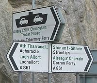
The ferry to Tobermory on Mull runs from the main village of Ardnamurchan, Kilchoan.
Extreme west

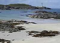
At the end of the peninsula is Ardnamurchan Point, on which stands lighthouse 188 feet high. It is commonly described as the most westerly point of the mainland of Great Britain, though in fact Corrachadh Mòr, a little to the south, holds that honour
Corrachadh Mòr lies less than a mile to the south of Ardnamurchan Point. It is not accessible by road and can be reached only be a rough hike over the hills. Its fame is that it is a few yards further west than Ardnamurchan Point and so it is the westernmost point of mainland Great Britain. In August 2011, Andy Strangeway of Yorkshire slept at Corrachadh Mòr as one stage of his feat of sleeping at each of the six extreme points of Great Britain (south, east, west, north, highest and lowest) on consecutive nights.
Geology
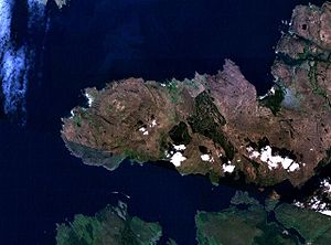
The whole north western corner of Ardnamurchan contains a complex of volcanic structures, often described approximately as a "Caldera". Broadly, this area is the underground structures of a 55 million-year-old volcanic complex (relatively small areas of lavas that were erupted onto the surface are found in some parts of the peninsula). At least 7 other similar complexes of the same tectonic episode are dotted up the west coast of Britain, and so are popular stops in geological training courses from many universities. Geological research continues in the area to this day, as well as training. The sub-concentric rings of the volcanic complex can easily be seen in the satellite photograph, or topographic map, though they are less obvious on the ground.
History

Donaldson equates 'Buarblaig' (now Bourblaige about 5 miles east of Kilchoan on the other side of Ben Hiant, NM546623[1]) with Muribulg, where the Annals of Tigernach record a battle between the Picts and Dalriads in 731.[2] It may also be the 'Muirbole Paradisi' mentioned by Adomnán.[1] Although its stone foundations still remain, the village of Bourblaige no longer exists, having been subject to destruction during the period of the Highland Clearances in the early nineteenth century.[3]
Tradition has it that there have been at least two battles in the bays between Gortenfern and Sgeir a' Chaolais, in the northeast of the peninsula across Kentra Bay from Ardtoe. One involved the Vikings, the other may have been fought in 1297 in Cul na Croise between the forces of Edward I and islanders under Roderick of Bute and Lachlan MacRuari of Garmoran.[4] Relics of a Viking ship burial in Cul na Croise have been given to the West Highland Museum at Fort William.[4]
Villages
The population of the whole peninsula is around 2,000. Villages in Ardnamurchan:
- Acharacle (Àth Tharracail)
- Achnaha (Achadh na h-Àtha)
- Glenborrodale (Gleann Bhorghdail)
- Glenmore
- Kilchoan (Cille Chòmhghain)
- Kilmory (Cill Mhóire)
- Laga
- Ockle (Ocal)
- Portuairk (Port Uairce)
- Sanna (Sanna)
Culture

Ardnamurchan has one of the highest concentrations of Gaelic speakers on the mainland. The Peninsula also has its own shinty team, Ardnamurchan Camanachd.
Birds, beasts and blooms
Rare species such as the wildcat, pine marten, golden eagle and white-tailed eagle can be seen in Ardnamurchan.
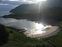
Ardnamurchan is widely considered by many who visit it to be one of the most stunning natural parts of the Scottish coast. It is beautiful, utterly wild and unspoilt. The most stunning of all perhaps, is Ardnamurchan Point, adjacent to the furthest westerly point on the British Mainland. Here there is a lighthouse, and in addition, a view from a sheer rock face of the open Atlantic Ocean.
Outside links
Notes and references
- ↑ 1.0 1.1 Site Record for Ardnamurchan, Bourblaige, Royal Commission on the Ancient and Historical Monuments of Scotland, http://canmore.rcahms.gov.uk/
- ↑ Donaldson, M E M (1923). Wanderings in the Western Highlands and Islands.
- ↑ http://www.scotlandsplaces.gov.uk/search_item/index.php?service=RCAHMS&id=90622
- ↑ 4.0 4.1 Site Record for Ardnamurchan, Gortenfern, Sgeir A' Chaolais; Gorten Bay, Royal Commission on the Ancient and Historical Monuments of Scotland, http://canmore.rcahms.gov.uk/en/site/22495/. The bays of Cul na Croise and Camas an Lighe are in NM6269.