Chirk: Difference between revisions
Created page with '{{Infobox town |name=Chirk |county=Denbighshire |welsh=Y Waun |os grid ref=SJ295375 |latitude=52.93026 |longitude=-3.05025 |post town=Wrexham |postcode=LL14 |dialling code=01691 …' |
No edit summary |
||
| Line 3: | Line 3: | ||
|county=Denbighshire | |county=Denbighshire | ||
|welsh=Y Waun | |welsh=Y Waun | ||
|picture=Y Waun parish church.jpg | |||
|picture caption=St Mary's Parish Church | |||
|os grid ref=SJ295375 | |os grid ref=SJ295375 | ||
|latitude=52.93026 | |latitude=52.93026 | ||
|longitude=-3.05025 | |longitude=-3.05025 | ||
|population=4,468 | |||
|census year=2011<ref>[https://www.nomisweb.co.uk/reports/localarea?compare=1170221515 2011 census]</ref> | |||
|post town=Wrexham | |post town=Wrexham | ||
|postcode=LL14 | |postcode=LL14 | ||
| Line 12: | Line 16: | ||
|constituency=Clwyd South | |constituency=Clwyd South | ||
}} | }} | ||
'''Chirk''' is a | '''Chirk''' is a town and ancient parish in [[Denbighshire]], adjacent to the border with [[Shropshire]], marked here by the [[River Ceiriog]]. It stands between [[Wrexham]] in Denbighshire and [[Oswestry]] in Shropshire. [[Chirk Bank]] lies to the south of the Ceiriog in the latter county. | ||
The Welsh language name for the place is 'Y Waun'', meaning ''The Moor''. | The Welsh language name for the place is 'Y Waun'', meaning ''The Moor''. | ||
| Line 19: | Line 23: | ||
==Parish church== | ==Parish church== | ||
The Parish Church of St Mary's is a Grade I listed building. The current church building was begun during the 11th Century by the Normans, although it is believed that an older llan, dedicated to St Tysilio, had existed on the site. Indeed, the current church was known by the dedication of St Tysilio until the late 15th or early 16th century, after which it was re-dedicated to St Mary. Today, the church is a member of the Open Church Network and participates in the Sacred Space Project. | The Parish Church of St Mary's is a Grade-I listed building. The current church building was begun during the 11th Century by the Normans, although it is believed that an older ''llan'', dedicated to St Tysilio, had existed on the site. Indeed, the current church was known by the dedication of St Tysilio until the late 15th or early 16th century, after which it was re-dedicated to St Mary. Today, the church is a member of the Open Church Network and participates in the Sacred Space Project. | ||
==History and heritage== | ==History and heritage== | ||
[[Chirk Castle]], a [[National Trust for Places of Historic Interest or Natural Beauty|National Trust]] property, is a mediæval castle by Chirk. Two families are associated with the town and its castle, the Trevor family of Brynkinallt and the Myddletons. The Hughes of Gwerclas, a family descended from the ancient kings of [[Powys]], also dwelt in the area for many years. | [[Chirk Castle]], a [[National Trust for Places of Historic Interest or Natural Beauty|National Trust]] property, is a mediæval castle by Chirk. Two families are associated with the town and its castle, the Trevor family of Brynkinallt and the Myddletons. The Hughes of Gwerclas, a family descended from the ancient kings of [[Powys]], also dwelt in the area for many years. | ||
Attractions in the town apart from Chirk Castle include a section of [[Offa's Dyke]] and the Chirk Aqueduct on the [[Llangollen Canal]], built in 1801 by Thomas Telford. The Glyn Valley Tramway operated from here. | Attractions in the town apart from Chirk Castle include a section of [[Offa's Dyke]] and the [[Chirk Aqueduct]] on the [[Llangollen Canal]], built in 1801 by Thomas Telford. The Glyn Valley Tramway operated from here. | ||
Chirk was formerly a coal mining community with coal being worked since the 17th century. The largest of these collieries were Black Park (one of the oldest in the north of Wales) and Brynkinallt. These coal mines have now also closed. | Chirk was formerly a coal mining community with coal being worked since the 17th century. The largest of these collieries were Black Park (one of the oldest in the north of Wales) and Brynkinallt. These coal mines have now also closed. | ||
| Line 33: | Line 36: | ||
The [[Chester]] to [[Ruabon]] railway had been extended south to [[Shrewsbury]] by 1848 with stations at Llangollen Road (at Whitehurst) and Chirk. South of the town a railway viaduct was constructed by Henry Robertson to take the line over the Ceiriog Valley. | The [[Chester]] to [[Ruabon]] railway had been extended south to [[Shrewsbury]] by 1848 with stations at Llangollen Road (at Whitehurst) and Chirk. South of the town a railway viaduct was constructed by Henry Robertson to take the line over the Ceiriog Valley. | ||
The Llangollen branch of the [[Shropshire Union Canal]] runs through Chirk. The canal crosses the Ceiriog Valley (from Denbighshire into Shropshire) along Thomas Telford's aqueduct. Telford's aqueduct runs alongside the Robertson' viaduct before the canal enters the Chirk Tunnel. | The Llangollen branch of the [[Shropshire Union Canal]] runs through Chirk. The canal crosses the Ceiriog Valley (from Denbighshire into Shropshire) along Thomas Telford's aqueduct. Telford's aqueduct runs alongside the Robertson' viaduct before the canal enters the [[Chirk Tunnel]]. | ||
==Sights in the town== | ==Sights in the town== | ||
[[File:Y Waun AqueductWales.JPG|right|thumb| | [[File:Y Waun AqueductWales.JPG|right|thumb|250px|Looking towards Chirk over the Aqueduct and Viaduct from the Shropshire side]] | ||
The Ceiriog Memorial Institute, in the Ceiriog valley, just west of Chirk, is home to a collection of Welsh cultural memorabilia and was founded in the early 1900s to support the Welsh language, culture and heritage for future generations. | The Ceiriog Memorial Institute, in the Ceiriog valley, just west of Chirk, is home to a collection of Welsh cultural memorabilia and was founded in the early 1900s to support the Welsh language, culture and heritage for future generations. | ||
Latest revision as of 12:04, 5 June 2018
| Chirk Welsh: Y Waun | |
| Denbighshire | |
|---|---|
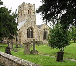
 St Mary's Parish Church | |
| Location | |
| Grid reference: | SJ295375 |
| Location: | 52°55’49"N, 3°3’1"W |
| Data | |
| Population: | 4,468 (2011[1]) |
| Post town: | Wrexham |
| Postcode: | LL14 |
| Dialling code: | 01691 |
| Local Government | |
| Council: | Wrexham |
| Parliamentary constituency: |
Clwyd South |
Chirk is a town and ancient parish in Denbighshire, adjacent to the border with Shropshire, marked here by the River Ceiriog. It stands between Wrexham in Denbighshire and Oswestry in Shropshire. Chirk Bank lies to the south of the Ceiriog in the latter county.
The Welsh language name for the place is 'Y Waun, meaning The Moor.
The town is served by Chirk railway station.
Parish church
The Parish Church of St Mary's is a Grade-I listed building. The current church building was begun during the 11th Century by the Normans, although it is believed that an older llan, dedicated to St Tysilio, had existed on the site. Indeed, the current church was known by the dedication of St Tysilio until the late 15th or early 16th century, after which it was re-dedicated to St Mary. Today, the church is a member of the Open Church Network and participates in the Sacred Space Project.
History and heritage
Chirk Castle, a National Trust property, is a mediæval castle by Chirk. Two families are associated with the town and its castle, the Trevor family of Brynkinallt and the Myddletons. The Hughes of Gwerclas, a family descended from the ancient kings of Powys, also dwelt in the area for many years.
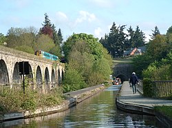
Attractions in the town apart from Chirk Castle include a section of Offa's Dyke and the Chirk Aqueduct on the Llangollen Canal, built in 1801 by Thomas Telford. The Glyn Valley Tramway operated from here.
Chirk was formerly a coal mining community with coal being worked since the 17th century. The largest of these collieries were Black Park (one of the oldest in the north of Wales) and Brynkinallt. These coal mines have now also closed.
Chirk was a coaching stop on the old Mail coach route along the road from London to Holyhead.
The Chester to Ruabon railway had been extended south to Shrewsbury by 1848 with stations at Llangollen Road (at Whitehurst) and Chirk. South of the town a railway viaduct was constructed by Henry Robertson to take the line over the Ceiriog Valley.
The Llangollen branch of the Shropshire Union Canal runs through Chirk. The canal crosses the Ceiriog Valley (from Denbighshire into Shropshire) along Thomas Telford's aqueduct. Telford's aqueduct runs alongside the Robertson' viaduct before the canal enters the Chirk Tunnel.
Sights in the town

The Ceiriog Memorial Institute, in the Ceiriog valley, just west of Chirk, is home to a collection of Welsh cultural memorabilia and was founded in the early 1900s to support the Welsh language, culture and heritage for future generations.
The town's industries are the manufacture of wood-based panels at Kronospan and chocolate manufacture at Cadbury.
Sport
- Football: Chirk AAA FC, founded in 1876.
Outside links
- Chirk Town Council website
- BBC Wales - Chirk website
- The Glyn Valley Tramway Trust in Chirk
- St Mary's Church, Chirk
- History of St Marys, Chirk
- Wrexham & Shropshire Railway
References
- G. G. Lerry, "Collieries of Denbighshire", 1968