The Dodman: Difference between revisions
mNo edit summary |
mNo edit summary |
||
| Line 18: | Line 18: | ||
Until we brought to by the [[South Foreland]] light.</poem>}} | Until we brought to by the [[South Foreland]] light.</poem>}} | ||
{{clear}} | |||
{{coord|50.219|-4.803|display=title}} | {{coord|50.219|-4.803|display=title}} | ||
{{DEFAULTSORT:Dodman}} | {{DEFAULTSORT:Dodman}} | ||
[[Category:Hill forts in Cornwall]] [[Category:Headlands of Cornwall]] [[Category:National Trust properties in Cornwall]] | [[Category:Hill forts in Cornwall]] [[Category:Headlands of Cornwall]] [[Category:National Trust properties in Cornwall]] | ||
Revision as of 09:51, 25 March 2013

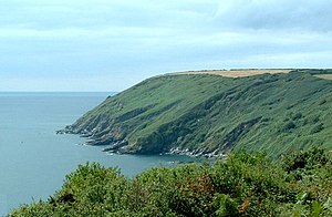
The Dodman or Dodman Point is a 400-foot high headland on the south coast of Cornwall, near Mevagissey. An Iron Age promontory fort once stood here.
At the seaward end of the Dodman is a large granite cross, erected to help protect shipping from this headland. To its northeast and in its lee is the small anchorage and sand beach of Gorran Haven.
Below the large stone cross, there is a way down to the bottom of the small cliffs and there is some climbing there on the faces. Mainly bouldering as it is rarely climbed and so there are no fixed anchor points.
The headland is part of the coast hereabouts which is owned by the National Trust.

Spanish Ladies
The headland is mentioned in the shanty Spanish Ladies as the first seamark on the coat for returning ships:
| “ | ” |
Coordinates: 50°13′08″N 4°48′11″W / 50.219°N 4.803°W