Trundle Island: Difference between revisions
Created page with "{{Infobox island |name=Trundle Island |territory=BAT |picture= |picture caption= |latitude=-65.3938 |longitude=-65.2885 |map= |group=Pitt Islands |area= |summit= }} '''Trundle..." |
|||
| (One intermediate revision by the same user not shown) | |||
| Line 6: | Line 6: | ||
|latitude=-65.3938 | |latitude=-65.3938 | ||
|longitude=-65.2885 | |longitude=-65.2885 | ||
|map= | |map=Trundle Island - Pitt Islands, BAT.svg | ||
|group=Pitt Islands | |group=Pitt Islands | ||
|area= | |area= | ||
| Line 19: | Line 19: | ||
==References== | ==References== | ||
*{{basgaz}} | *{{basgaz}} | ||
{{Pitt Islands}} | |||
Latest revision as of 13:23, 4 December 2022
| Trundle Island | |
| Location | |
| Location: | 65°23’38"S, 65°17’19"W |
| Data | |
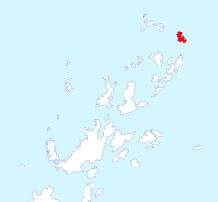
Trundle Island lies in the north-east of the Pitt Islands, a group within the Biscoe Islands group in the British Antarctic Territory.
The isle was roughly charted by an Argentine expedition in 1954-55. It was photographed from the air by the Falkland Islands and Dependencies Aerial Survey Expedition in 1956.
As with other names amongst the Pitt Islands, this island is named after character in the Pickwick Papers; after Mr Trundle, who marries Isabella Wardle.
References
- Gazetteer and Map of The British Antarctic Territory: Trundle Island
| Pitt Islands, British Antarctic Territory |
|---|
|
Ánimas • Bardell Rock • Dickens Rocks • Fizkin • Jingle • Jinks • Lacuna • Nupkins Island • Pickwick Island • Sawyer Island • Slumkey Island • Smiggers Island • Snodgrass Island • Snubbin Island • Trundle Island • Tupman Island • Weller Island • Winkle |
