Thurgarton Wapentake: Difference between revisions
No edit summary |
No edit summary |
||
| (One intermediate revision by one other user not shown) | |||
| Line 7: | Line 7: | ||
*[[Bleasby]] | *[[Bleasby]] | ||
*[[Burton Joyce]] | *[[Burton Joyce]] | ||
*[[Calverton]] | *[[Calverton, Nottinghamshire|Calverton]] | ||
*[[Caunton]] | *[[Caunton]] | ||
*[[Colwick]] | *[[Colwick]] | ||
| Line 39: | Line 39: | ||
*[[Oxton, Nottinghamshire|Oxton]] | *[[Oxton, Nottinghamshire|Oxton]] | ||
*Park Leys (ex. par.) | *Park Leys (ex. par.) | ||
*[[Rolleston]] | *[[Rolleston, Nottinghamshire|Rolleston]] | ||
*[[Sneinton]] | *[[Sneinton]] | ||
*[[Southwell]] | *[[Southwell]] | ||
Latest revision as of 12:55, 5 September 2022

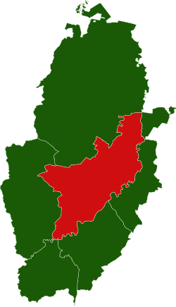
Thurgarton Wapentake is one of the wapentakes or hundreds of Nottinghamshire, in the centre of the county. It is named after the village of Thurgarton, which it contains. It is bounded by every other wapentake: by Bassetlaw to the north; by Newark Wapentake to the east; by Bingham Wapentake to the south-east; and by Broxtow to the south-west. There is also a short border with Rushcliffe between Sneinton and West Bridgford. It had a population of 128,908 in 2011.
It comprises the ancient parishes of:
- Averham
- Bleasby
- Burton Joyce
- Calverton
- Caunton
- Colwick
- Cromwell
- Edingly
- Epperstone
- Farnsfield
- Fledborough
- Gedling
- Gonalston
- Halam
- Halloughton
- Haywood Oaks (ex. par.)
- Hockerton
- Holme
- Hoveringham
- Kelham
- Kirklington
- Kneesall (except Ompton)*
- Lambley
- Lindhurst (ex. par.)
- Lowdham
- Maplebeck
- Marnham
- Meering (ex. par.)
- Morton
- Normanton on Trent
- North Muskham
- Norwell
- Ossington
- Oxton
- Park Leys (ex. par.)
- Rolleston
- Sneinton
- Southwell
- South Muskham
- Sutton-on-Trent
- Thurgarton
- Upton
- Weston
- Winkburn
- Woodborough
*: In Bassetlaw wapentake.
Additionally, Census reports include East Stoke in Thurgarton wapentake, with a footnote that it was sometimes attributed to Bingham or Newark wapentakes.
| Wapentakes of Nottinghamshire |
|---|
|
Bassetlaw • Bingham • Broxtow (including Nottingham) • Newark • Rushcliffe • Thurgarton |