Tedburn St Mary: Difference between revisions
Jump to navigation
Jump to search
Created page with "{{Infobox town |name=Tedburn St Mary |county=Devon |picture=Church Tower, Town Barton - geograph.org.uk - 1433136.jpg |picture caption=Church Tower, Town Barton@, Tedburn St M..." |
No edit summary |
||
| Line 3: | Line 3: | ||
|county=Devon | |county=Devon | ||
|picture=Church Tower, Town Barton - geograph.org.uk - 1433136.jpg | |picture=Church Tower, Town Barton - geograph.org.uk - 1433136.jpg | ||
|picture caption=Church | |picture caption=Church in Town Barton, by Tedburn St Mary | ||
|os grid ref=SX815940 | |os grid ref=SX815940 | ||
|latitude=50.734114 | |latitude=50.734114 | ||
Latest revision as of 19:52, 21 December 2018
| Tedburn St Mary | |
| Devon | |
|---|---|
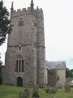
 Church in Town Barton, by Tedburn St Mary | |
| Location | |
| Grid reference: | SX815940 |
| Location: | 50°44’3"N, 3°40’45"W |
| Data | |
| Postcode: | EX6 |
| Local Government | |
| Council: | Teignbridge |
| Parliamentary constituency: |
Teignbridge |
Tedburn St Mary is a village in the midst of Devon, about eight miles west of the county town, Exeter. It has a population of approximately 1,500.
The village is on the old road west from Exeter heading north of Dartmoor towards Launceston, but is now bypassed, the A30 running just to the south of Tedburn St Mary.
The church of St Mary is at Town Barton, the former site of the village which is north of the present one. The west tower has diagonal buttresses and a polygonal stair turret. The nave is unusually wide; the north transept and the north aisle may be 14th century. The chancel was rebuilt in 1868.[1]
The Trafalgar Way long-distance route runs through the village.
Outside links
| ("Wikimedia Commons" has material about Tedburn St Mary) |
References
- ↑ Nikolaus Pevsner: Pevsner Architectural Guides
