Langley, Essex: Difference between revisions
No edit summary |
|||
| Line 14: | Line 14: | ||
|constituency= | |constituency= | ||
}} | }} | ||
'''Langley''' is a village in [[Essex]], seven miles west-south-west of [[Saffron Walden]], and about 15 miles south of city [[Cambridge]]. | '''Langley''' is a village in [[Essex]], seven miles west-south-west of [[Saffron Walden]], and about 15 miles south of the city of [[Cambridge]]. | ||
Langley is broken into two parts, Langley Upper Green{{getmap|TL445351}} to the | Langley is broken into two parts, Langley Upper Green ({{getmap|TL445351}}) to the north-east and Langley Lower Green ({{getmap|TL437344}}) to the south-west, which two parts are linked by Bull Lane and by footpaths. The adult population of the whole is fewer than 300. | ||
The church is in Upper Green, while the pub, the Bull Inn, is in Lower Green. | The church is in Upper Green, while the pub, the Bull Inn, is in Lower Green. | ||
North of Langley stretches farmland and in the midst of it [[Chrishall Common]], a great stretch of land between Langley and [[Chrishall]] some miles off to the north. Chrishall lies north of the B1039, which follows the valley of a brook, and Langley lies to the south down a single narrow road. Off this road 2½ miles | North of Langley stretches farmland and in the midst of it [[Chrishall Common]], a great stretch of land between Langley and [[Chrishall]] some miles off to the north. Chrishall lies north of the B1039, which follows the valley of a brook, and Langley lies to the south down a single narrow road. Off this road 2½ miles north-east of Langley is the hamlet of [[Duddenhoe End]], which lends a name to Duddenhoe Grange, the large farm north of Langley. | ||
Langley is the closest village to Essex’s [[county top]], in the High Wood on Langley Common, and it is from Langley that the county top is best reached, on one of the footpaths running off from beghind the parish church. | Langley is the closest village to Essex’s [[county top]], in the High Wood on Langley Common, and it is from Langley that the county top is best reached, on one of the footpaths running off from beghind the parish church. | ||
==Parish church== | ==Parish church== | ||
The parish church is St John the Evangelist,a modest church at the top of a pretty little lane in Langley Upper Green. | The parish church is St John the Evangelist, a modest church at the top of a pretty little lane in Langley Upper Green. | ||
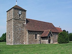
St John’s was founded as a chapel, built in the 12th century of flint rubble but since extended: its west tower was built in the 14th century with stone rusticated quoins. The church now has a modern tiled pyramid roof. The chancel was built in about 1560 of red brick. | St John’s was founded as a chapel, built in the 12th century of flint rubble but since extended: its west tower was built in the 14th century with stone rusticated quoins. The church now has a modern tiled pyramid roof. The chancel was built in about 1560 of red brick. | ||
Latest revision as of 11:33, 26 January 2016
| Langley | |
| Essex | |
|---|---|
 St John the Evangelist, Langley | |
| Location | |
| Grid reference: | TL445351 |
| Location: | 51°59’44"N, -0°6’12"E |
| Data | |
| Population: | First argument to "number_format" must be a number. |
| Post town: | Saffron Walden |
| Postcode: | CB11 |
| Dialling code: | 01799 |
| Local Government | |
| Council: | Uttlesford |
Langley is a village in Essex, seven miles west-south-west of Saffron Walden, and about 15 miles south of the city of Cambridge.
Langley is broken into two parts, Langley Upper Green (TL445351) to the north-east and Langley Lower Green (TL437344) to the south-west, which two parts are linked by Bull Lane and by footpaths. The adult population of the whole is fewer than 300.
The church is in Upper Green, while the pub, the Bull Inn, is in Lower Green.
North of Langley stretches farmland and in the midst of it Chrishall Common, a great stretch of land between Langley and Chrishall some miles off to the north. Chrishall lies north of the B1039, which follows the valley of a brook, and Langley lies to the south down a single narrow road. Off this road 2½ miles north-east of Langley is the hamlet of Duddenhoe End, which lends a name to Duddenhoe Grange, the large farm north of Langley.
Langley is the closest village to Essex’s county top, in the High Wood on Langley Common, and it is from Langley that the county top is best reached, on one of the footpaths running off from beghind the parish church.
Parish church
The parish church is St John the Evangelist, a modest church at the top of a pretty little lane in Langley Upper Green.
St John’s was founded as a chapel, built in the 12th century of flint rubble but since extended: its west tower was built in the 14th century with stone rusticated quoins. The church now has a modern tiled pyramid roof. The chancel was built in about 1560 of red brick.
The church was restored in 1885. The restoration preserved but heavily repaired the late 15th century double hammer beam roof. The church is Grade II* listed for its interior architectural features.
Outside links
| ("Wikimedia Commons" has material about Langley, Essex) |
