County Monaghan: Difference between revisions
Created page with '{{Infobox county |name=County Monaghan |irish=Contae Mhuineacháin |map image=Island of Ireland location map Monaghan.svg |picture= |picture caption= |province=Ulster |area= …' |
|||
| (6 intermediate revisions by 2 users not shown) | |||
| Line 2: | Line 2: | ||
|name=County Monaghan | |name=County Monaghan | ||
|irish=Contae Mhuineacháin | |irish=Contae Mhuineacháin | ||
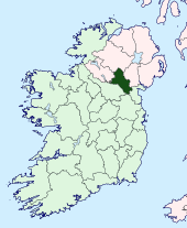
|map image= | |map image=Monaghan Ireland (BI Sect 7).svg | ||
|picture= | |picture=Shannahergoa Townland - geograph.org.uk - 168118.jpg | ||
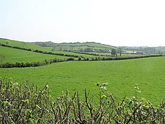
|picture caption= | |picture caption=Countryside at Shannahergoa, Co. Monaghan | ||
|province=[[Ulster]] | |province=[[Ulster]] | ||
|county town=[[Monaghan]] | |county town=[[Monaghan]] | ||
|biggest town= | |biggest town= | ||
}} | }} | ||
The '''County of Monaghan''' is a [[Counties of the Republic of Ireland|shire]] in the province of [[Ulster]] in the republic of Ireland. It is named after the town of Monaghan. The population of the county is 60,483 according to the 2011 census. | |||
==Geography== | |||
Monaghan is the fifth smallest of the Republic's 26 counties in area and fourth smallest by population.<ref>{{cite book| first=Eoghan| last=Corry| title=The GAA Book of Lists| publisher=Hodder Headline Ireland| year=2005| id= | pages=186–191}}</ref> It is the smallest of Ulster's nine counties in size and also the smallest in terms of population. | |||
The [[townland]] of Gubdoo forms a detached part of the county, locally situate in [[Fermanagh]].<ref>Townland of Gubdoo: {{wmap|54.123018|-7.33283|zoom=14|base=outline_detached}}</ref> | |||
===Baronies=== | |||
*Cremorne ({{lang|ga|Críoch Mhúrn}}) | |||
*Dartree ({{lang|ga|Dartraighe}}) | |||
*Farney ({{lang|ga|Fearnaigh}}) | |||
*Monaghan ({{lang|ga|Muineachán}}) | |||
*Trough ({{lang|ga|An Triúcha}}) | |||
===Parishes=== | |||
{{parishliststart}} | |||
*[[Aghabog]] | |||
*[[Aghnamullen]] | |||
*[[Ballybay]] | |||
*[[Clones]]<sup>*</sup> | |||
*[[Clontibret]] | |||
*[[Currin]]<sup>*</sup> | |||
*[[Donagh]] | |||
*[[Donaghmoyne]] | |||
*[[Drummully]] | |||
*[[Drumsnat]] | |||
*[[Ematris]] | |||
*[[Errigal Trough]]<sup>†</sup> | |||
*[[Inishkeen]]<sup>‡</sup> | |||
*[[Killanny]]<sup>‡</sup> | |||
*[[Killeevan]] | |||
*[[Kilmore, County Monaghan|Kilmore]] | |||
*[[Magheracloone]] | |||
*[[Magheross]] | |||
*[[Monaghan]] | |||
*[[Muckno]] | |||
*[[Tedavnet]] | |||
*[[Tehallan]] | |||
*[[Tullycorbet]] | |||
{{parishlistend}} | |||
<sup>*</sup>: Extends into [[Fermanagh]].<br /><sup>†</sup>: Extends into [[Tyrone]]. | |||
<br /><sup>‡</sup>: Extends into [[County Louth]].<br />Additionally the parish of [[Drummully]] extends into County Monaghan. | |||
===Largest towns=== | |||
1. Monaghan = 7,452 <br /> | |||
2. Carrickmacross = 4,925 <br /> | |||
3. Castleblayney = 3,634 <br /> | |||
4. Clones = 1,761 <br /> | |||
5. Ballybay = 1,461 | |||
===Geography=== | |||
Notable mountains include Mullyash Mountain, Slieve Beagh (on the border with Tyrone and [[Fermanagh]]) and Coolberrin Hill (702 ft). Lakes include Lough Egish, Lough Fea, Muckno Lough, Lough Avaghon, Inner Lough (in Dartrey Forest), Drumlona Lough, White Lough and Emy Lough. Rivers in Monaghan include the River Fane (along the Louth border), the River Glyde (along the Louth and Meath borders), the Ulster Blackwater (along the border with [[County Tyrone]]) and the Dromore river (along the border of [[County Cavan]], linking Cootehill to Ballybay). | |||
Monaghan has a number of forests, including Rossmore Forest, Dartrey Forest and Dún na Rí Forest Park. Managed by Coillte since 1988, the majority of trees are conifers. Due to a long history of intensive farming and recent intensive forestry practices, only small pockets of native woodland remain. | |||
The Finn Bridge is a border crossing point over the River Finn between County Monaghan and County Fermanagh. It is close to Scotshouse. | |||
[[File:Clones Round Tower - geograph.org.uk - 289630.jpg|right|220px|thumb|Clones Round Tower]] | |||
==History== | |||
In 1585, the English lord deputy of Ireland, Sir John Perrot, visited the area and met the chieftains. They requested that Ulster be divided into counties and land in the kingdom of Airgíalla be apportioned to each of the McMahon chiefs. A commission was established to accomplish this and County Monaghan came into being. The county was subdivided into five baronies: Farney, Cremorne, Dartrey, Monaghan and Truagh, which was left under the control of the McKenna chieftains. | |||
After the defeat of the rebellion of Hugh O'Neill, The O'Neill and the Ulster chieftains in 1603, the county was not planted like the other counties of Ulster. The lands were instead left in the hands of the native chieftains. In the Irish Rebellion of 1641 the McMahons and their allies joined the general rebellion of Irish Catholics. Following their defeat, some plantation of the county took place with Scottish and English families. | |||
==Inland waterways== | |||
County Monaghan is traversed by the Ulster Canal but is not fully open to navigation, however Waterways Ireland are embarking on a scheme to reopen the canal from Lough Erne into Clones. | |||
==Culture and architecture== | |||
County Monaghan is the birthplace of the poet and writer Patrick Kavanagh, who based much of his work in the county. Kavanagh is one of the most significant figures in 20th century Irish poetry. The poems "Stony Grey Soil" and "Shancoduff" refer to the county. | |||
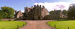
[[File:CastleLeslieSummer2006.jpg|260px|thumb|Castle Leslie]] | |||
Monaghan has produced several successful artists. Chief among these is George Collie (1904–75), who was born in Carrickmacross and trained at the Dublin Metropolitan School of Art. He was a prolific exhibitor at the Royal Hibernian Academy throughout his lifetime and is represented by works in the collection of the National Gallery of Ireland and the Ulster Museum. | |||
Monaghan was also the home county of the Irish writer Sir Shane Leslie (1885–1971), 3rd Baronet of Glaslough, who lived at Castle Leslie in the north-east corner of the county. A Catholic convert, Irish nationalist and first cousin of British Prime Minister Sir Winston Churchill, Leslie became an important literary figure in the early 1900s. He was a close friend of many politicians and writers of the day including the American novelist F. Scott Fitzgerald (1896–1940), who dedicated his second novel, ''The Beautiful and Damned'', to Leslie. | |||
Monaghan County Museum is recognised as one of the leading provincial museums in Ireland, with a Council of Europe Award (1980), among others, to its credit. Located in Hill Street, Monaghan Town, the museum aims to reflect the history of Co. Monaghan and its people in all its richness and diversity. | |||
The best of the county's architecture developed in the Georgian and Victorian periods and ranges from the dignified public spaces of Church Square and The Diamond in Monaghan Town to the great country houses of Lough Fea, Carrickmacross; Hilton Park, Clones and Castle Leslie, Glaslough. | |||
Significant ecclesiastical buildings include St. Joseph's Roman Catholic Church, Carrickmacross, which houses a set of stained glass windows by the Irish artist Harry Clarke (1889–1931); the Gothic-Revival St. Patrick's Church of Ireland, Monaghan town; and the impressive St. Macartan's Roman Catholic Cathedral, Monaghan town, by J. J. McCarthy (1817–1882). | |||
==Notes== | |||
{{reflist}} | |||
{{commons category}} | |||
{{stub}} | {{stub}} | ||
{{Irish county}} | {{Irish county}} | ||
Latest revision as of 12:58, 5 November 2015
| County Monaghan Irish: Contae Mhuineacháin Republic of Ireland | |
 Countryside at Shannahergoa, Co. Monaghan | |
|---|---|

| |
| [Interactive map] | |
| Province: | Ulster |
| Area: | 500 square miles |
| Population: | 60,483 |
| County seat: | Monaghan |
The County of Monaghan is a shire in the province of Ulster in the republic of Ireland. It is named after the town of Monaghan. The population of the county is 60,483 according to the 2011 census.
Geography
Monaghan is the fifth smallest of the Republic's 26 counties in area and fourth smallest by population.[1] It is the smallest of Ulster's nine counties in size and also the smallest in terms of population.
The townland of Gubdoo forms a detached part of the county, locally situate in Fermanagh.[2]
Baronies
- Cremorne (Irish: Críoch Mhúrn)
- Dartree (Irish: Dartraighe)
- Farney (Irish: Fearnaigh)
- Monaghan (Irish: Muineachán)
- Trough (Irish: An Triúcha)
Parishes
*: Extends into Fermanagh.
†: Extends into Tyrone.
‡: Extends into County Louth.
Additionally the parish of Drummully extends into County Monaghan.
Largest towns
1. Monaghan = 7,452
2. Carrickmacross = 4,925
3. Castleblayney = 3,634
4. Clones = 1,761
5. Ballybay = 1,461
Geography
Notable mountains include Mullyash Mountain, Slieve Beagh (on the border with Tyrone and Fermanagh) and Coolberrin Hill (702 ft). Lakes include Lough Egish, Lough Fea, Muckno Lough, Lough Avaghon, Inner Lough (in Dartrey Forest), Drumlona Lough, White Lough and Emy Lough. Rivers in Monaghan include the River Fane (along the Louth border), the River Glyde (along the Louth and Meath borders), the Ulster Blackwater (along the border with County Tyrone) and the Dromore river (along the border of County Cavan, linking Cootehill to Ballybay).
Monaghan has a number of forests, including Rossmore Forest, Dartrey Forest and Dún na Rí Forest Park. Managed by Coillte since 1988, the majority of trees are conifers. Due to a long history of intensive farming and recent intensive forestry practices, only small pockets of native woodland remain.
The Finn Bridge is a border crossing point over the River Finn between County Monaghan and County Fermanagh. It is close to Scotshouse.

History
In 1585, the English lord deputy of Ireland, Sir John Perrot, visited the area and met the chieftains. They requested that Ulster be divided into counties and land in the kingdom of Airgíalla be apportioned to each of the McMahon chiefs. A commission was established to accomplish this and County Monaghan came into being. The county was subdivided into five baronies: Farney, Cremorne, Dartrey, Monaghan and Truagh, which was left under the control of the McKenna chieftains.
After the defeat of the rebellion of Hugh O'Neill, The O'Neill and the Ulster chieftains in 1603, the county was not planted like the other counties of Ulster. The lands were instead left in the hands of the native chieftains. In the Irish Rebellion of 1641 the McMahons and their allies joined the general rebellion of Irish Catholics. Following their defeat, some plantation of the county took place with Scottish and English families.
Inland waterways
County Monaghan is traversed by the Ulster Canal but is not fully open to navigation, however Waterways Ireland are embarking on a scheme to reopen the canal from Lough Erne into Clones.
Culture and architecture
County Monaghan is the birthplace of the poet and writer Patrick Kavanagh, who based much of his work in the county. Kavanagh is one of the most significant figures in 20th century Irish poetry. The poems "Stony Grey Soil" and "Shancoduff" refer to the county.

Monaghan has produced several successful artists. Chief among these is George Collie (1904–75), who was born in Carrickmacross and trained at the Dublin Metropolitan School of Art. He was a prolific exhibitor at the Royal Hibernian Academy throughout his lifetime and is represented by works in the collection of the National Gallery of Ireland and the Ulster Museum.
Monaghan was also the home county of the Irish writer Sir Shane Leslie (1885–1971), 3rd Baronet of Glaslough, who lived at Castle Leslie in the north-east corner of the county. A Catholic convert, Irish nationalist and first cousin of British Prime Minister Sir Winston Churchill, Leslie became an important literary figure in the early 1900s. He was a close friend of many politicians and writers of the day including the American novelist F. Scott Fitzgerald (1896–1940), who dedicated his second novel, The Beautiful and Damned, to Leslie.
Monaghan County Museum is recognised as one of the leading provincial museums in Ireland, with a Council of Europe Award (1980), among others, to its credit. Located in Hill Street, Monaghan Town, the museum aims to reflect the history of Co. Monaghan and its people in all its richness and diversity.
The best of the county's architecture developed in the Georgian and Victorian periods and ranges from the dignified public spaces of Church Square and The Diamond in Monaghan Town to the great country houses of Lough Fea, Carrickmacross; Hilton Park, Clones and Castle Leslie, Glaslough.
Significant ecclesiastical buildings include St. Joseph's Roman Catholic Church, Carrickmacross, which houses a set of stained glass windows by the Irish artist Harry Clarke (1889–1931); the Gothic-Revival St. Patrick's Church of Ireland, Monaghan town; and the impressive St. Macartan's Roman Catholic Cathedral, Monaghan town, by J. J. McCarthy (1817–1882).
Notes
- ↑ Corry, Eoghan (2005). The GAA Book of Lists. Hodder Headline Ireland. pp. 186–191.
- ↑ Townland of Gubdoo: 54°7’23"N, 7°19’58"W
| ("Wikimedia Commons" has material about Monaghan County Monaghan) |
This county article is a stub: help to improve Wikishire by building it up.
| Counties of the Republic of Ireland |
|---|
|
Carlow • Cavan • Clare • Cork • Donegal • Dublin • Galway • Kerry • Kildare • Kilkenny • Laois • Leitrim • Limerick • Longford • Louth • Mayo • Meath • Monaghan • Offaly • Roscommon • Sligo • Tipperary • Waterford • Westmeath • Wexford • Wicklow |
