An Coileachan: Difference between revisions
mNo edit summary |
No edit summary |
||
| (One intermediate revision by one other user not shown) | |||
| Line 5: | Line 5: | ||
|picture=River Grudie - geograph.org.uk - 1576572.jpg | |picture=River Grudie - geograph.org.uk - 1576572.jpg | ||
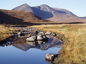
|picture caption=An Coileachan across the River Grudie | |picture caption=An Coileachan across the River Grudie | ||
|height= | |SMC=14 | ||
|os grid ref | |height=3,028 feet | ||
|latitude=57.6674 | |||
|longitude=-4.950685 | |||
|os grid ref=NH241680 | |||
}} | }} | ||
'''An Coileachan''' is a mountain in the [[Fannichs]] group, the easternmost of the nine [[munro]]s of the Fannichs, mountains over 3,000 feet. | '''An Coileachan''' is a mountain of 3,028 feet in the [[Fannichs]] group, the easternmost of the nine [[munro]]s of the Fannichs, mountains over 3,000 feet. | ||
The summit of An Coileachan is in Ross-shire, though its western slopes are in | The summit of An Coileachan is in Ross-shire, though its western slopes are in a detached part of [[Cromartyshire]], which latter shire takes in most of the highest mountains of the range. | ||
The mountain rises up to the south of [[Loch Gorm]], a steep-sided dome. | The mountain rises up to the south of [[Loch Gorm]], a steep-sided dome. | ||
Latest revision as of 08:05, 14 September 2018
| An Coileachan | |||
| Ross-shire | |||
|---|---|---|---|
 An Coileachan across the River Grudie | |||
| Range: | Fannichs | ||
| Summit: | 3,028 feet NH241680 57°40’3"N, 4°57’2"W | ||
An Coileachan is a mountain of 3,028 feet in the Fannichs group, the easternmost of the nine munros of the Fannichs, mountains over 3,000 feet.
The summit of An Coileachan is in Ross-shire, though its western slopes are in a detached part of Cromartyshire, which latter shire takes in most of the highest mountains of the range.
The mountain rises up to the south of Loch Gorm, a steep-sided dome.
Ascent

An Coileachan might be approached on the track from the shore of Loch Fannich, which is close by. However the usual approach from the north is a long trail across the bogs and through the burns, for the main road, the A835, is to the north.
An Coileachan can conveniently be climbed along with others of the Fannichs' mountains and tops, in particular with nearby Meall Gorm or on a circular route including a descent to the shores of the splendid but isolated Loch Fannich.
| Munros in SMC Area SMC Section 14 - Loch Maree to Loch Broom |
|---|
|
A' Chailleach • A' Mhaighdean • An Coileachan • Beinn Liath Mhòr Fannaich • Beinn Tarsuinn • Bidein a' Ghlas Thuill • Fionn Bheinn • Meall a' Chrasgaidh • Meall Gorm • Mullach Coire Mhic Fhearchair • Ruadh Stac Mòr • Sgùrr Bàn • Sgùrr Breac • Sgùrr Fiona • Sgùrr Mòr • Sgùrr nan Clach Geala • Sgùrr nan Each • Slioch |