Stanstead Abbotts: Difference between revisions
Created page with '{{Infobox town |name=Stanstead Abbotts |county=Hertfordshire |picture=The High Street at Stanstead Abbotts - geograph.org.uk - 730563.jpg |picture caption=The High Street at Sta…' |
No edit summary |
||
| Line 18: | Line 18: | ||
The [[Greenwich Meridian]] passes through the village with its exact position marked by Meridian obelisks which were erected in 1984 to commemorate the centenary of the adoption of the prime meridian line.<ref>[http://www.stanstead-abbotts-online.co.uk/about.html Stanstead Abbotts Online]</ref> | The [[Greenwich Meridian]] passes through the village with its exact position marked by Meridian obelisks which were erected in 1984 to commemorate the centenary of the adoption of the prime meridian line.<ref>[http://www.stanstead-abbotts-online.co.uk/about.html Stanstead Abbotts Online]</ref> | ||
The village is found some | The village is found some five miles south [[Ware]], and 6½ miles southeast of [[Hertford]]. Hoddesdon and the conurbation of the lea Valley towns is closer, three miles south. Stanstead Abbotts however is separated from them across the river. It stands on the west side of the [[River Lea]], north of the point where the [[River Stort]] enters it, and in the angle between these two rivers, Stanstead Abbotts is alone. It cannot escape the town however; where the rivers meet south of the village is a complex of canal basins and sewage works. | ||
The village of [[Stanstead St Margarets]] is across the River Lea, and across the Stort in Essex is [[Roydon]]. | The village of [[Stanstead St Margarets]] is across the River Lea, and across the Stort in Essex is [[Roydon]]. | ||
Latest revision as of 19:50, 18 August 2014
| Stanstead Abbotts | |
| Hertfordshire | |
|---|---|
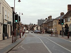
 The High Street at Stanstead Abbotts | |
| Location | |
| Grid reference: | TL4011 |
| Location: | 51°47’19"N, -0°-0’44"E |
| Data | |
| Population: | 1,983 |
| Post town: | Ware |
| Postcode: | SG12 |
| Dialling code: | 01920 |
| Local Government | |
| Council: | East Hertfordshire |
| Parliamentary constituency: |
Hertford and Stortford |
Stanstead Abbotts (or Stanstead Abbots) is a village in Hertfordshire, in the east of the county, close by the border with Essex. At the 2001 census the parish had a population of 1,983.
The Greenwich Meridian passes through the village with its exact position marked by Meridian obelisks which were erected in 1984 to commemorate the centenary of the adoption of the prime meridian line.[1]
The village is found some five miles south Ware, and 6½ miles southeast of Hertford. Hoddesdon and the conurbation of the lea Valley towns is closer, three miles south. Stanstead Abbotts however is separated from them across the river. It stands on the west side of the River Lea, north of the point where the River Stort enters it, and in the angle between these two rivers, Stanstead Abbotts is alone. It cannot escape the town however; where the rivers meet south of the village is a complex of canal basins and sewage works.
The village of Stanstead St Margarets is across the River Lea, and across the Stort in Essex is Roydon.
History
Name and origins
The village's name was recorded as "Stanstede" at the time of the Domesday Book in 1086. In the twelfth century the manor passed to the abbot of Waltham Holy Cross. By the fourteenth century the suffix "Abbatis", "Abbotts" or "Abbot" formed part of the parish's name. The abbey continued possession of the manor until its dissolution in 1531.[2][3]
The manor of Stanstead Abbotts was granted to Anne Boleyn and remained with the crown after her execution. In 1559 Queen Elizabeth granted it to Edward Baeshe and it remained in the Bashe family for several generation.[2]
The Village
Once situated on the main A414 it has many old buildings in its High Street although many have now made way for newer residential properties because the village is on the main railway line into Liverpool Street Station. The main industry in the village used to be making ale but again many of the original maltings have now been demolished to make way for a small business park.
The main entrance to the All Nations Christian College in Stanstead Abbotts was used as the entrance to the school in the "St Trinians" films.
The Lee Valley Marina, part of the Lee Valley Park, is located to the south of the village on the River Lea.[4]
Big Society
The village has a Scout Group, the 1st Stanstead Abbotts & St. Margaret's Scout Group.[5]
Sport and leisure
Stanstead Abbotts has a Non-League football club St Margaretsbury FC, which plays at The Recreation Ground.
Outside links
| ("Wikimedia Commons" has material about Stanstead Abbotts) |
References
- ↑ Stanstead Abbotts Online
- ↑ 2.0 2.1 Parishes: Stanstead Abbots - A History of the County of Hertford: volume 3 (Victoria County History)
- ↑ Hertfordshire County Council. "Stanstead Abbots". Hertfordshire Extensive Urban Survey. Archaeology Data Service. http://ads.ahds.ac.uk/catalogue/adsdata/herteus_eh_2005/ahds/dissemination/pdf/stanstead_abbots.pdf. Retrieved 23 December 2009.
- ↑ "Lee Valley Regional Park Authority - Stanstead Marina". http://www.leevalleypark.org.uk/en/content/cms/leisure/water_sports___activ/stanstead_marina/stanstead_marina.aspx. Retrieved 12 August 2009.
- ↑ "1st Stanstead Abbotts & St. Margaret's Scout Group". http://www.stansteadabbottsscouts.org.uk. Retrieved 12 August 2009.
