Beachy Head: Difference between revisions
Created page with 'thumb|right|300px|Beachy Head cliffs and lighthouse from the west '''Beachy Head…' |
No edit summary |
||
| (One intermediate revision by the same user not shown) | |||
| Line 1: | Line 1: | ||
{{county|Sussex}} | |||
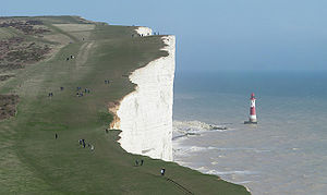
[[File:Beachy Head and Lighthouse, East Sussex, England - April 2010 crop horizon corrected.jpg|thumb|right|300px|Beachy Head cliffs and lighthouse from the west]] | [[File:Beachy Head and Lighthouse, East Sussex, England - April 2010 crop horizon corrected.jpg|thumb|right|300px|Beachy Head cliffs and lighthouse from the west]] | ||
'''Beachy Head''' is a vast chalk headland punching out from the south coast of [[Sussex]], close to the town of [[Eastbourne]] | '''Beachy Head''' is a vast chalk headland punching out from the south coast of [[Sussex]], close to the town of [[Eastbourne]]. The cliff at Beachy Head is the highest chalk sea cliff in Britain, rising to 530 feet above sea level. The peak allows views of the south east coast from [[Dungeness (headland)|Dungeness]] to the east, to [[Selsey Bill]] in the west. | ||
Beachy Head marks the point where the vast arch of the [[South Downs]], having run from eastern [[Hampshire]] and all through Sussex, hemming the coastal towns in behind it, reaches the sea. | Beachy Head marks the point where the vast arch of the [[South Downs]], having run from eastern [[Hampshire]] and all through Sussex, hemming the coastal towns in behind it, reaches the sea. | ||
| Line 56: | Line 57: | ||
==Outside links== | ==Outside links== | ||
*Location map: {{wmap|50.7375|0.2475|zoom=14}} | |||
* [http://www.beachyhead.org Beachy Head Countryside Centre] | * [http://www.beachyhead.org Beachy Head Countryside Centre] | ||
* [http://www.eastbourne.org/tourism/beachyhead/ Beachy Head], Eastbourne website | * [http://www.eastbourne.org/tourism/beachyhead/ Beachy Head], Eastbourne website | ||
Latest revision as of 19:17, 18 May 2023

Beachy Head is a vast chalk headland punching out from the south coast of Sussex, close to the town of Eastbourne. The cliff at Beachy Head is the highest chalk sea cliff in Britain, rising to 530 feet above sea level. The peak allows views of the south east coast from Dungeness to the east, to Selsey Bill in the west.
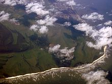
Beachy Head marks the point where the vast arch of the South Downs, having run from eastern Hampshire and all through Sussex, hemming the coastal towns in behind it, reaches the sea.
Immediately west is a series of cliffs known as the Seven Sisters.
Geology

The chalk was formed in the late Cretaceous Period, between 65 and 100 million years ago, when the area was under the sea. During the Cenozoic Era the chalk was uplifted. At the end of the last Ice Age, sea levels rose dramatically and the English Channel formed, cutting into the chalk, bursting through and leaving Europe cut off, and forming the dramatic cliffs of this part of the Sussex coast.
Wave action contributes towards the erosion of cliffs around Beachy Head, which experience frequent small rock falls. Since chalk forms in layers separated by contiguous bands of flints, the physical structure affects how the cliffs erode. Wave action undermines the lower cliffs, causing frequent slab failures - slabs from layers of chalk break off, undermining the upper parts of the cliffs, which eventually collapse.[1] In contrast to small rock falls, mass movements are less common. A mass movement happened in 2001 when, after a winter of heavy rain, the water had begun to seep into the cracks, which water then froze and caused the cracks to widen. This caused a large collapse at the cliff edge into the sea.

Tourism
West of Belle Tout, the cliffs drop down to Birling Gap, and beyond that the Seven Sisters. The area is a popular tourist attraction. Birling Gap has a restaurant and, in the summer, multiple ice cream vans serve the area.
Suicide spot
Despite the beauty of the location, Beachy Head has also attracted a gruesome reputation as a notorious suicide spot. Since the 17th century it has been known for people to attempt suicide, estimated at 20 each year.[2] The Beachy Head Chaplaincy Team conducts regular day and evening patrols of the area in attempts to locate and stop potential jumpers. There are also posted signs with the telephone number of The Samaritans urging potential jumpers to call them. Worldwide, the landmark’s suicide rate is surpassed only by the Golden Gate Bridge in San Francisco and the Aokigahara Woods in Japan.[3]
After a steady increase in deaths between 2002 and 2005, in 2006 there were only seven fatalities, a marked decrease.[4] The Maritime and Coastguard Agency attributed the reduction to the work of the Chaplaincy Team and good coverage of services by local media.[4][5]
History

The name Beachy Head appears as 'Beauchef' in 1274, and was 'Beaucheif' in 1317, becoming consistently Beachy Head by 1724. It has nothing to do with beaches but appears to be a corruption of the original French words meaning "beautiful headland".[6]
In 1929 the town of Eastbourne bought 4,000 acres of land surrounding Beachy Head to save it from development at a cost of about £100,000.[7]
The prominence of Beachy Head has made it a landmark for sailors in the English Channel. It is noted as such in the sea shanty Spanish Ladies:
The first land we sighted was called the Dodman,
Next Rame Head off Plymouth, off Portsmouth the Wight;
We sailed by Beachy, by Fairlight and Dover,
And then we bore up for the South Foreland light.
[8]
Lighthouses
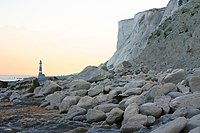
The headland was a danger to shipping. In 1831 construction began on Belle Tout lighthouse on the next headland west from Beachy Head. It became operational in 1834.
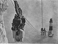
Because mist and low clouds could hide the light of Belle Tout, another lighthouse was built in the sea below Beachy Head. It was 141 feet in height and became operational in October 1902.[6] For more than 80 years, the red-and-white striped tower was manned by three lighthouse keepers whose job was to maintain the light, which rotates two white flashes every 20 seconds and is visible 26 miles out to sea. Trinity House announced in June 2010 that in late September 2010, the light is to be reduced to 8 nautical miles and the fog signal discontinued. The lighthouse was fully automated in 1983 and the keepers withdrawn.
Due to cliff erosion, in March 1999 Belle Tout lighthouse was moved more than 50 feet further inland.[9]
Beachy Head at war
The third day of fighting in the Battle of Portland of 1653, took place off Beachy Head during the First Anglo-Dutch War. Another naval engagement, the Battle of Beachy Head of 1690 was fought during the Nine Years' War. The battle ended an attempt by the deposed King James II & VII to return and it re-established English naval supremacy in the Channel over the French.
During the Second World War, the RAF established a forward relay station at Beachy Head to improve radio communications with aircraft. In 1942, signals were picked up at Beachy Head which were identified as TV transmissions from the Eiffel Tower; the Germans had reactivated the pre-war TV transmitter and instituted a Franco-German service for military hospitals and VIPs in the Paris region. The RAF monitored these programmes hoping (in vain) to gather intelligence from newsreels. There was also an important wartime radar station in the area and, during the Cold War, a radar control centre was operational in an underground bunker from 1953 to 1957.[6]
References
- ↑ Beachy Head - Photographs and Geological commentary
- ↑ "Suicide jump child 'already dead'". BBC News Online (BBC). June 2, 2009. http://news.bbc.co.uk/1/hi/england/sussex/8078490.stm. Retrieved 2009-06-02.
- ↑ "Exiting Early". http://online.wsj.com/article/SB114504929764426405.html?mod=googlewsj. Retrieved 2010-11-16.
- ↑ 4.0 4.1 "Beachy Head suicide numbers down". BBC News Online (BBC). December 20, 2006. http://news.bbc.co.uk/1/hi/england/southern_counties/6196661.stm. Retrieved 2009-06-02.
- ↑ "Beachy Head Press Release". MCA Press Release (UK Maritime and Coastguard Agency). http://www.mcga.gov.uk/c4mca/mcga-newsroom/mcga-press-releases.htm?id=2BC6351816ACF22F&m=12&y=2006. Retrieved 2009-06-02.
- ↑ 6.0 6.1 6.2 Surtees, Dr John (1997). Beachy Head. Seaford: SB Publications. ISBN 1 85770 118 6.
- ↑ Times, October 30, 1929. P. 11
- ↑ Palmer, Roy (1986). The Oxford Book of Sea Songs. Oxford: Oxford University Press. ISBN 0192141597.
- ↑ "The 28 foot move that took a day". The Argus. 18 March 1999.
Outside links
- Location map: 50°44’15"N, -0°14’51"E
- Beachy Head Countryside Centre
- Beachy Head, Eastbourne website
- Beachy Head walk to East Dean
- Landslides at Beachy Head British Geological Survey
- Beachy Head Chaplaincy Team