Hall Island, Willis Islands: Difference between revisions
Jump to navigation
Jump to search
m RB moved page Hall Island to Hall Island, Willis Islands |
|||
| Line 16: | Line 16: | ||
==References== | ==References== | ||
*{{basgaz}} | *{{basgaz|Hall Island}} | ||
{{SGSSI}} | {{SGSSI}} | ||
Latest revision as of 19:40, 22 October 2021
| Hall Island | |
|
Willis Islands
| |
|---|---|
| Location | |
| Location: | 54°0’23"N, 38°8’34"W |
| Data | |
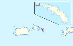
Hall Island is one of the Willis Islands, which lie off the western tip of South Georgia. It lies between the Verdant Islands and Proud Island.
This isle was named after Captain Geoffrey Penrose Dickinson Hall (b. 1916), commanding HMS Owen during the hydrographic survey of this area in 1960-61; and who served as Hydrographer of the Navy 1971-75.
References
- Gazetteer and Map of South Georgia and the South Sandwich Islands: Hall Island
| South Georgia and the South Sandwich Islands | |
|---|---|
| South Georgia: | Annenkov Island • Bird Island • Clerke Rocks • Cooper Island • Grass Island • Kupriyanov Islands • Pickersgill Islands • Saddle Island • Shag Rocks • South Georgia • Welcome Islands • Willis Islands • Trinity Island • Grassholm • Black Rocks • Black Rock |
| South Sandwich Islands: |
Bellingshausen • Bristol • Candlemas • Cook • Leskov • Montagu • Saunders • Thule • Vindication • Visokoi • Zavodovski |
