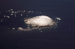
Visokoi Island
| Visokoi Island | |
|
South Sandwich Islands
| |
|---|---|
 Visokoi Island | |
| Location | |
| Location: | 27°12’-0"S, 56°42’0"W |
| Data | |
Visokoi Island is an uninhabited island in the Traversay Islands group of the South Sandwich Islands. It was discovered in 1819 by a Russian expedition under Fabian Gottlieb von Bellingshausen, who named the island Visokoi ("high") because of its conspicuous height.[1]
The island is 4½ miles long and 3 miles wide, capped by Mount Hodson, a volcanic peak of 3,297 feet. The peak is named after Sir Arnold Weinholt Hodson, a governor of the Falkland Islands.
The island's eastern tip, Point Irving, is named for the commander of a British exploratory and mapping expedition, John J Irving. Cmdr (the father of British historian David Irving).
References
- ↑ Mills, William James (2003). Exploring polar frontiers: a historical encyclopedia. A - L.. ABC-CLIO. p. 680. ISBN 978-1-57607-422-0. http://books.google.com/books?id=PYdBH4dOOM4C&pg=PA680. Retrieved 6 January 2012.
- Gazetteer and Map of South Georgia and the South Sandwich Islands: Visokoi Island}
- LeMasurier, W. E.; Thomson, J W (eds.) (1990). Volcanoes of the Antarctic Plate and Southern Oceans. American Geophysical Union. p. 512 pp. ISBN 0-87590-172-7.
- Hodson Volcano
- Irving Letters
| South Georgia and the South Sandwich Islands | |
|---|---|
| South Georgia: | Annenkov Island • Bird Island • Clerke Rocks • Cooper Island • Grass Island • Kupriyanov Islands • Pickersgill Islands • Saddle Island • Shag Rocks • South Georgia • Welcome Islands • Willis Islands • Trinity Island • Grassholm • Black Rocks • Black Rock |
| South Sandwich Islands: |
Bellingshausen • Bristol • Candlemas • Cook • Leskov • Montagu • Saunders • Thule • Vindication • Visokoi • Zavodovski |
This South Georgia and the South Sandwich Islands article is a stub: help to improve Wikishire by building it up.