Gedney Drove End: Difference between revisions
Created page with "{{Infobox town |name=Gedney Drove End |county=Lincolnshire |picture=B1359 in Gedney Drove End (geograph 3568688).jpg |picture caption=B1359 road into Gedney Drove End..." |
|||
| Line 43: | Line 43: | ||
==References== | ==References== | ||
{{reflist}} | {{reflist}} | ||
{{Gedney}} | |||
Latest revision as of 18:12, 25 July 2021
| Gedney Drove End | |
| Lincolnshire | |
|---|---|
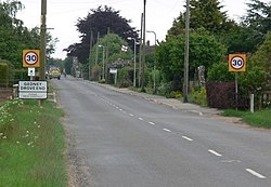
 B1359 road into Gedney Drove End | |
| Location | |
| Grid reference: | TF463293 |
| Location: | 52°50’29"N, -0°10’17"E |
| Data | |
| Post town: | Spalding |
| Postcode: | PE12 |
| Dialling code: | 01406 |
| Local Government | |
| Council: | South Holland |
| Parliamentary constituency: |
South Holland and The Deepings |
Gedney Drove End is a village in the parish of Gedney in Holland, the south-eastern part of Lincolnshire. It is 40 miles south-east of the county town, the City of Lincoln, and twelve miles from each of Boston to the north-west and King's Lynn to the south-east.
The village is within Gedney Marsh, five miles north-east of the parish village, Gedney itself, and a mile from the south-west shore of the Wash. The village is centred where Marsh Road runs into Dawsmere Road at the junction with Main Road, the B1359 road which runs from the village to Long Sutton.
There are two public houses, 'The Rising Sun' on Marsh Road and 'The Wildfowler on the Wash' on Main Road; also on Main Road is Gedney Drove Primary School. The village hall, which is shared with the neighbouring hamlet of Dawsmere, is on Dawsmere Road.
About the village
At the west of Gedney Drove End, separated by fields and at the centre of a farm, is Norfolk House, a Grade II listed red brick house dating to the early 19th century.[1] At the north of the village, on the bank of The Wash is an infantry blockhouse from the Second World War.[2] Further south-east off Marsh Road is a "Type 23 three-bay concrete anti-aircraft pillbox".[3]
At the centre of the village is evidence of Gedney Drove End post-mediæval settlement, and the extant Methodist chapel dating from 1885[4][5]
To the north of the village centre is the site of a former corn tower mill, non-existent by 1953.[6][7]
Gedney Drove was made an ecclesiastical district in 1855, and from then until 1870 services were held in the village schoolroom until the church at Dawsmere was built. Sunday afternoon services were held at a mission house in the village. In 1872 the Primitive Methodist Chapel was recorded. Occupations and trades at the time included a schoolmistress, eleven farmers, two coal dealers, a miller & baker, a further baker who was also the post master, a shoemaker, two carpenters, one of whom was also a wheelwright, a blacksmith, a grocer & draper, a boatman coastguard, the occupant of a beerhouse, and the licensed victualler of The Wheatsheaf public house.[8]
See also
- Gedney
- Gedney Broadgate
- Gedney Dyke
- Gedney Hill
- Gedney Marsh
- Gedney Church End
Outside links
| ("Wikimedia Commons" has material about Gedney Drove End) |
References
- ↑ National Heritage List 1064578: Norfolk House (Grade II listing)
- ↑ National Monuments Record: No. 1419891 – Blockhouse at Gedney Drove End
- ↑ National Monuments Record: No. 1419893 – Anti-aircraft pillbox
- ↑ National Monuments Record: No. 1476126 – Methodist chapel
- ↑ Gedney Drove End Primitive Methodist chapel: My Primitive Methodists
- ↑ National Monuments Record: No. 498123 – Site of tower mill
- ↑ Windmill, Gedney Drove End: Lincs to the Past
- ↑ Whites Directory of Lincolnshire (1872), pp.739, 740
| Gedney and Gedney Marsh, in Lincolnshire |
|---|
|
Gedney • Gedney Broadgate • Gedney Church End • Dawsmere • Gedney Drove End • Gedney Dyke • Gedney Hill • Gedney Marsh |
