Walney Island: Difference between revisions
Created page with '{{Infobox island | name = Walney Island | picture = Jubilee.JPG | picture caption = Walney From Barrow-in-Furness | map = WalneyInLancashire.PNG | sea = Irish Sea | area = 5.0…' |
No edit summary |
||
| (5 intermediate revisions by 2 users not shown) | |||
| Line 1: | Line 1: | ||
{{Infobox island | {{Infobox island | ||
| name = Walney Island | |name=Walney Island | ||
| picture = Jubilee.JPG | |county=Lancashire | ||
| picture caption | |group= | ||
| map | |picture=Jubilee.JPG | ||
| sea = Irish Sea | |picture caption=Walney From Barrow-in-Furness | ||
| area = 5 | |map=Walney in Lancashire.svg | ||
|sea=Irish Sea | |||
| main | |area=5 square miles | ||
| population = 13,000 | |main town=Biggar | ||
|population=13,000 | |||
|latitude=54.103 | |||
|longitude=-3.252 | |||
}} | }} | ||
'''Walney Island''', also known as the '''Isle of Walney''', lies off the coast of the [[Furness]] peninsula of [[Lancashire]]. | '''Walney Island''', also known as the '''Isle of Walney''', lies off the coast of the [[Furness]] peninsula of [[Lancashire]]. | ||
[[File:Silhouettes of grass.jpg|thumb| | [[File:Silhouettes of grass.jpg|thumb|250px|Summer, Walney]] | ||
The island lies in the [[Irish Sea]] to the west of the Furness peninsula. It has been connected to [[Barrow in Furness]] on the mainland by the Jubilee Bridge since 1908. The Jubilee Bridge spans [[Walney Channel]] and until its commission, a ferry was used in order to cross the channel. | The island lies in the [[Irish Sea]] to the west of the Furness peninsula. It has been connected to [[Barrow in Furness]] on the mainland by the Jubilee Bridge since 1908. The Jubilee Bridge spans [[Walney Channel]] and until its commission, a ferry was used in order to cross the channel. | ||
The island is around eleven miles long and less than a mile wide at its widest point. Its total area is | The island is around eleven miles long and less than a mile wide at its widest point. Its total area is five square miles. The island was developed to house workers of Vickers Shipbuilding and Engineering Ltd, with an area of the island retaining the name [[Vickerstown]] today. | ||
Walney has a golf course, an outdoor children's play area and two wildlife reserves (North Walney, a National Nature Reserve, and South Walney). There are a number of Sites of Special Scientific Interest, providing a habitat for natterjack toads as well as many species of birds. | Walney has a golf course, an outdoor children's play area and two wildlife reserves (North Walney, a National Nature Reserve, and South Walney). There are a number of Sites of Special Scientific Interest, providing a habitat for natterjack toads as well as many species of birds. | ||
[[File:Barrow Offshore wind turbines.jpg|thumb| | [[File:Barrow Offshore wind turbines.jpg|thumb|250px|Barrow Offshore windfarm]] | ||
The island is said to be the windiest lowland site in England.<ref>"[http://www.nwemail.co.uk/news/viewarticle.aspx?id=459955 ''On The Crest of a Wave'']," ''Northwest Evening Mail'' (26/01/2007).</ref> Recently an offshore wind farm has been built almost | The island is said to be the windiest lowland site in England.<ref>"[http://www.nwemail.co.uk/news/viewarticle.aspx?id=459955 ''On The Crest of a Wave'']," ''Northwest Evening Mail'' (26/01/2007).</ref> Recently an offshore wind farm has been built almost five miles off the island's West coast. The wind farm consists of thirty 300-foot 3 MW wind turbines. Construction was completed in September 2006.<ref name="bowind" >{{cite web | ||
| title=Barrow Offshore windfarm | | title=Barrow Offshore windfarm | ||
| url=http://www.bowind.co.uk | | url=http://www.bowind.co.uk | ||
| Line 34: | Line 36: | ||
*[[Biggar]] | *[[Biggar]] | ||
*North Scale | *North Scale | ||
* North Walney | *North Walney | ||
*South Walney | *South Walney | ||
*[[Vickerstown]] | *[[Vickerstown]] | ||
==History== | ==History== | ||
Axe and arrow heads have been found on Walney from the bronze age, indicating that the island has been settled for at least around 3,000 years. | Axe and arrow heads have been found on Walney from the bronze age, indicating that the island has been settled for at least around 3,000 years. | ||
| Line 45: | Line 46: | ||
Walney is mentioned in the [[Domesday Book]] of 1086 as ''Hougenai'', possibly from an Old Norse name derived from ''haugr'' meaning "mound" or "hill".<ref>[http://www.viking.no/e/england/e-viking_words_2.htm#H ''Standard English words which have a Scandinavian Etymology'' (The Vikings in England)]</ref> | Walney is mentioned in the [[Domesday Book]] of 1086 as ''Hougenai'', possibly from an Old Norse name derived from ''haugr'' meaning "mound" or "hill".<ref>[http://www.viking.no/e/england/e-viking_words_2.htm#H ''Standard English words which have a Scandinavian Etymology'' (The Vikings in England)]</ref> | ||
==Outside links== | |||
*[http://www.walneyisle.co.uk/ Walney Isle in words and pictures] | |||
*[http://www.walney-island.com/ The Walney Island website] | |||
*[http://www.barrow-in-furness.info/walney-websites/ Walney websites] | |||
*[http://www.thecumbriadirectory.com/Town_or_Village/location.php?url=isle_of_walney Isle of Walney Directory] | |||
*[http://www.users.globalnet.co.uk/~rwbarnes/defence/walney.htm Information about the island's coastal artillery] | |||
*[http://www.birdobscouncil.org.uk/Walney/body_walney.htm Walney bird observatory] | |||
==References== | ==References== | ||
{{Reflist}} | {{Reflist}} | ||
{{Islands of Furness}} | |||
Latest revision as of 13:17, 8 September 2020
| Walney Island | |
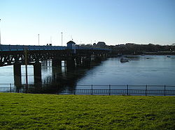
 Walney From Barrow-in-Furness | |
|---|---|
| Main town: | Biggar |
| Location | |
| Location: | 54°6’11"N, 3°15’7"W |
| Area: | 5 square miles |
| Data | |
| Population: | 13,000 |
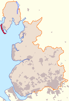
Walney Island, also known as the Isle of Walney, lies off the coast of the Furness peninsula of Lancashire.

The island lies in the Irish Sea to the west of the Furness peninsula. It has been connected to Barrow in Furness on the mainland by the Jubilee Bridge since 1908. The Jubilee Bridge spans Walney Channel and until its commission, a ferry was used in order to cross the channel.
The island is around eleven miles long and less than a mile wide at its widest point. Its total area is five square miles. The island was developed to house workers of Vickers Shipbuilding and Engineering Ltd, with an area of the island retaining the name Vickerstown today.
Walney has a golf course, an outdoor children's play area and two wildlife reserves (North Walney, a National Nature Reserve, and South Walney). There are a number of Sites of Special Scientific Interest, providing a habitat for natterjack toads as well as many species of birds.

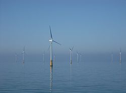
The island is said to be the windiest lowland site in England.[1] Recently an offshore wind farm has been built almost five miles off the island's West coast. The wind farm consists of thirty 300-foot 3 MW wind turbines. Construction was completed in September 2006.[2] There are plans for more wind farms with up to 100 turbines off the coast, to the dismay of some local people as the Island is famous for its sunsets and views off the West coast and if the turbines are erected in their proposed number, this may affect the island's popularity.
Walney Island has a small airport (Barrow/Walney Island Airport); privately owned by BAE Systems located at the northern end of the island, home to the Lakes Gliding Club.
Towns and villages
The island has a population of about 13,000. The five main settlements are:
- Biggar
- North Scale
- North Walney
- South Walney
- Vickerstown
History
Axe and arrow heads have been found on Walney from the bronze age, indicating that the island has been settled for at least around 3,000 years.
The name "Walney" is thought to come from the Old Norse valna ey, of uncertain meaning, though 'Isle of the Britons' has been suggested, cognate with Old English Wealna Ieg. The area was within Norse influence during the Viking Age and may have attracted Norse settlers. One of the main areas of settlement, Biggar Village has been inhabited since at least the 11th century.
Walney is mentioned in the Domesday Book of 1086 as Hougenai, possibly from an Old Norse name derived from haugr meaning "mound" or "hill".[3]
Outside links
- Walney Isle in words and pictures
- The Walney Island website
- Walney websites
- Isle of Walney Directory
- Information about the island's coastal artillery
- Walney bird observatory
References
- ↑ "On The Crest of a Wave," Northwest Evening Mail (26/01/2007).
- ↑ "Barrow Offshore windfarm". http://www.bowind.co.uk.
- ↑ Standard English words which have a Scandinavian Etymology (The Vikings in England)
| The Islands of Furness, Lancashire |
|---|
|
Barrow Island • Chapel Island • Dova Haw • Foulney Island • Headin Haw • Piel Island • Roa Island • Sheep Island • Walney Island |
