Llangedwyn: Difference between revisions
Jump to navigation
Jump to search
Created page with "{{Infobox town |name=Llangedwyn |county=Denbighshire |picture= |picture caption= |os grid ref=SJ185241 |latitude=52.80827 |longitude=-3.21050 |population= |census year=2001 |p..." |
No edit summary |
||
| (One intermediate revision by the same user not shown) | |||
| Line 2: | Line 2: | ||
|name=Llangedwyn | |name=Llangedwyn | ||
|county=Denbighshire | |county=Denbighshire | ||
|picture= | |picture=St Cedwyn's Parish Church - geograph.org.uk - 1399870.jpg | ||
|picture caption= | |picture caption=St Cedwyn's Parish Church | ||
|os grid ref=SJ185241 | |os grid ref=SJ185241 | ||
|latitude=52.80827 | |latitude=52.80827 | ||
| Line 15: | Line 15: | ||
|constituency=Montgomeryshire | |constituency=Montgomeryshire | ||
}} | }} | ||
'''Llangedwyn''' is a village and parish in southern [[Denbighshire]] adjacent to the borders with [[Montgomeryshire]] and [[Shropshire]]. | '''Llangedwyn''' is a village and parish in southern [[Denbighshire]], adjacent to the borders with [[Montgomeryshire]] and [[Shropshire]]. | ||
It lies in the [[Afon Tanat|Tanat Valley]] approximately five miles from the small town of [[Llanfyllin]] and ten miles from the Shropshire market town of [[Oswestry]]. The [[Berwyn | It lies in the [[Afon Tanat|Tanat Valley]] approximately five miles from the small town of [[Llanfyllin]] and ten miles from the Shropshire market town of [[Oswestry]]. The [[Berwyn Range|Berwyn mountain range]] is nearby, as is [[Pistyll Rhaeadr]] waterfall. The ruins of Owain Glyndŵr's Sycharth castle lie a few miles outside the village towards [[Llansilin]]. | ||
The Llangedywn Church In Wales Primary School is located in the village.<ref>{{cite web|url=http://www.llangedwynschool.org/|title=Llangedwyn Church In Wales Primary School|publisher=Llangedwyn Primary School|accessdate=6 July 2012}}</ref> | The Llangedywn Church In Wales Primary School is located in the village.<ref>{{cite web|url=http://www.llangedwynschool.org/|title=Llangedwyn Church In Wales Primary School|publisher=Llangedwyn Primary School|accessdate=6 July 2012}}</ref> | ||
| Line 26: | Line 26: | ||
{{reflist}} | {{reflist}} | ||
== | == Outside links == | ||
{{commons category}} | {{commons category}} | ||
*[http://www.genuki.org.uk/big/wal/DEN/Llangedwyn/ GENUKI page] | *[http://www.genuki.org.uk/big/wal/DEN/Llangedwyn/ GENUKI page] | ||
{{stub}} | {{stub}} | ||
Latest revision as of 11:49, 16 April 2020
| Llangedwyn | |
| Denbighshire | |
|---|---|
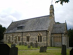
 St Cedwyn's Parish Church | |
| Location | |
| Grid reference: | SJ185241 |
| Location: | 52°48’30"N, 3°12’38"W |
| Data | |
| Post town: | Oswestry |
| Postcode: | SY10 |
| Dialling code: | 01691 |
| Local Government | |
| Council: | Powys |
| Parliamentary constituency: |
Montgomeryshire |
Llangedwyn is a village and parish in southern Denbighshire, adjacent to the borders with Montgomeryshire and Shropshire.
It lies in the Tanat Valley approximately five miles from the small town of Llanfyllin and ten miles from the Shropshire market town of Oswestry. The Berwyn mountain range is nearby, as is Pistyll Rhaeadr waterfall. The ruins of Owain Glyndŵr's Sycharth castle lie a few miles outside the village towards Llansilin.
The Llangedywn Church In Wales Primary School is located in the village.[1]
Sir Watkin Williams-Wynn, 10th Baronet, heir of Owain Gwynedd, lived his final years at Llangedwyn Hall.[2]
Notes
- ↑ "Llangedwyn Church In Wales Primary School". Llangedwyn Primary School. http://www.llangedwynschool.org/. Retrieved 6 July 2012.
- ↑ London Gazette, issue 51666 published on 7 March 1989 (Supplement), p. 2874
Outside links
| ("Wikimedia Commons" has material about Llangedwyn) |
This Denbighshire article is a stub: help to improve Wikishire by building it up.
