Falkland Islands: Difference between revisions
No edit summary |
No edit summary |
||
| Line 5: | Line 5: | ||
|flag=Flag of the Falkland Islands.svg | |flag=Flag of the Falkland Islands.svg | ||
|arms=Coa Falkland.svg | |arms=Coa Falkland.svg | ||
|map image= | |map image=Falkland Islands location detail.svg | ||
|motto="Desire the right" | |motto="Desire the right" | ||
|capital=[[Stanley, Falkland Islands|Stanley]] | |capital=[[Stanley, Falkland Islands|Stanley]] | ||
Latest revision as of 22:47, 5 April 2020
| Falkland Islands (British overseas territory) | |
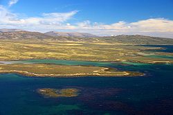 West Falkland, near Keppel Island | |
|---|---|
| |

| |
| "Desire the right" | |
| Area: | 4,700 square miles |
| Population: | 3,140 (July 2008 est) |
| Capital: | Stanley |
| Time zone: | GMT -4 |
| Dialling code: | +500 |
| TLD: | .fk |
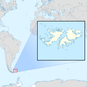
The Falkland Islands are an archipelago and British overseas territory in the South Atlantic Ocean. The islands lie some 250 nautical miles from the coast of South America. The archipelago consists of East Falkland, West Falkland and 776 lesser islands.
The islands became famous in 1982 when invaded by Argentina in pursuit of a long-festering territorial claim. The resultant Falklands War lasted for two months and resulted in the complete defeat and withdrawal of the Argentine forces.
Since the war, there has been strong economic growth in both fisheries and tourism.
Name
The Falkland Islands took their English name from "Falkland Sound", the channel between the two main islands, which was in turn named after Anthony Cary, 5th Viscount Falkland by Captain John Strong, who landed on the islands in 1690.[1]
A French name for the islands is Îles Malouines, given by Louis Antoine de Bougainville in 1764 after the first known settlers, mariners and fishermen from the port of Saint-Malô in Brittany, from which is derived the name used by Spanish-speaking nations, Islas Malvinas.[2] The use of this and other Spanish names is considered offensive in the Falkland Islands, particularly those names associated with the 1982 invasion of the Falkland Islands by Argentina.[3] General Sir Jeremy Moore would not allow the use of Islas Malvinas in the surrender document, dismissing it as a propaganda term.[4]
Geography and ecology

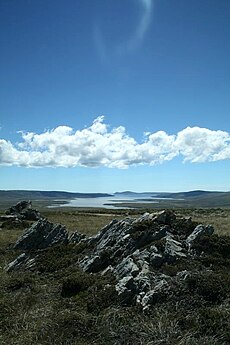
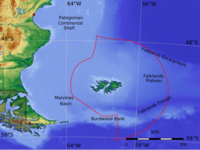
The Falkland Islands comprise two main islands, West Falkland and East Falkland and about 776 small islands.[5] The islands are heavily indented by sounds and fjords.
The islands are located 185 nautical miles[6] from Staten Island (off Tierra del Fuego) and 250 nautical miles[7] from the mainland of South America. The Falklands are 582 nautical miles[8] west of the Shag Rocks of South Georgia and 501 nautical miles[9] north of the British Antarctic Territory.
The total land area is 4,700 square miles; slightly smaller than Northern Ireland, with a coastline estimated at 800 miles.
The two main islands are East Falkland and West Falkland, on either side of Falkland Sound, and these make up most of the land. East Falkland contains the capital, Stanley, and most of the population. Both islands have mountain ranges
The islands' highest point is Mount Usborne, at 2,313 feet on East Falkland. There are also some boggy plains, most notably in Lafonia, the southern half of East Falkland. Almost the whole area of the islands is used as pasture for sheep.
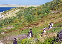
Great amounts of wildlife are found on the Falkland islands and in their seas. Native fauna include colonies of many sorts of penguin. Biogeographically, the Falkland Islands are classified as part of the Neotropical realm, together with South America. It is also classified as part of the Antarctic Floristic Kingdom.
The islands claim a territorial sea of 12 nautical miles and an exclusive fishing zone of 200 nautical miles.
Islands
Main islands
The main islands are:
Smaller islands
Smaller islands surround the main two. They include:
- Barren Island
- Beaver Island
- Bleaker Island
- Carcass Island
- George Island
- Keppel Island
- Lively Island
- New Island
- Pebble Island
- Saunders Island
- Sea Lion Island
- Speedwell Island
- Staats Island
- Weddell Island
- West Point Island.
Lesser islands
Lesser islands include:
- The Jason Islands, to the northwest of the main archipelago
- Beauchene Island some distance to its south.
- Speedwell Island and George Island are split from East Falkland by Eagle Passage.
Climate
Surrounded by cool South Atlantic waters, the Falkland Islands have a Maritime Subarctic climate (Koppen Cfc) that is very much influenced by the ocean in that it has a narrow annual temperature range. The January average maximum temperature is about 13°C (55°F), and the July maximum average temperature is about 4°C (39°F). The average annual rainfall is 22.58 inches but East Falkland is generally wetter than West Falkland.[10] Humidity and winds, however, are constantly high. Snow is rare but can occur at almost any time of year. Gales are very frequent, particularly in winter. The climate is similar to that of the Shetland islands, but with less rainfall and longer and slightly more severe winters.
Churches
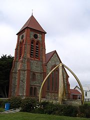
The Falkland Islands form a parish which is an extra-provincial church under the supervision of the Archbishop of Canterbury. It was formerly a diocese which at one time covered not only the islands but all Anglican missionary activity in South America, which work was so successful that the Church of the Southern Cone of America is now a thriving Anglican church, but from which the islands have been separated.
There are but three churches in the islands, all in Stanley: Christ Church Cathedral, The Tabernacle, United Free Church and St Mary's Roman Catholic Church, all Victorian buildings. The Cathedral was cmpleted in 1892. The whalebone arch in front of it was erected in 1933 to celebrate 100 years of resumed British rule.
History
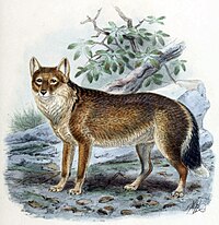
The islands were uninhabited when they were first discovered by British sailors, but there is evidence that Patagonian Indians may have reached the Falklands in canoes.[11] Artefacts including arrowheads and the remains of a canoe have been found on the islands.[12] There was also the presence of the Falkland Island fox, or Falkland Island Wolf (the Warrah) (now extinct), but warrahs may have reached the islands by way of a land bridge when the sea level was much lower during the last ice age.
Early Explorers
There is some dispute about which European explorer first set foot on the islands. Islands in the seas west of Patagonia appear on some Spanish and other maps beginning in the 1520s, but it is not known which islands they intend to show, if any genuine islands are portrayed.[12] The English explorer John Davis, commander of the Desire, one of the ships belonging to Thomas Cavendish's second expedition to the New World, is recorded as having visited the islands in 1592.[13] He was separated from Cavendish off the coast of Patagonia by a severe storm and discovered the islands. For a time the islands were known as "Davis Land".[11] In 1594, the English commander Richard Hawkins visited the islands. Combining his own name with that of Queen Elizabeth I, the "Virgin Queen", he gave them the name of "Hawkins' Maidenland." Many give the credit to Sebald de Weert, a Dutchman, who discovered the islands in 1600.[12]
In January 1690, Captain John Strong of the Welfare was heading for Puerto Deseado (now in Argentina). Driven off course by contrary winds, he reached the Sebald Islands instead and landed at Bold Cove. He sailed between the two principal islands and called the passage "Falkland Channel" (now Falkland Sound), after Anthony Cary, 5th Viscount Falkland, who as Commissioner of the Admiralty had financed the expedition (Cary later became First Lord of the Admiralty). The island group later took its English name from this body of water.
The first settlers
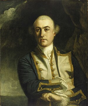
The first settlement on the Falkland Islands, named Port St Louis, was founded by the French navigator and military commander Louis Antoine de Bougainville on Berkeley Sound, in present-day Port Louis, East Falkland in 1764.
In January 1765, the British captain John Byron, unaware of the French presence, explored and claimed Saunders Island, at the western end of the group, where he named the harbour of Port Egmont. He sailed near other islands, which he also claimed for King George III. A British settlement was built at Port Egmont in 1766. Also in 1766, Spain acquired the French colony. Spain attacked Port Egmont, ending the British presence there in 1770. The expulsion of the British settlement brought the two countries to the brink of war, but a peace treaty allowed the British to return to Port Egmont in 1771 with neither side relinquishing sovereignty.[14]
In 1774, as a result of economic pressures leading up to the American Revolutionary War, Great Britain withdrew her garrisons unilaterally from many of her overseas settlements, including Port Egmont.[15][16] On their withdrawal in 1776 they left behind a plaque asserting Britain's claims. Spain abandoned the islands in 1811 and also left behind a plaque asserting a claim.
On 6 November 1820, an American privateer, Colonel David Jewett raised the flag of the United Provinces of the River Plate (Argentina) at Port Louis. Jewett was in the employment of Buenos Aires businessman Patrick Lynch to captain his ship, the frigate Heroína (Lynch had obtained a letter of marque from the Buenos Aires Supreme Director José Rondeau). Jewett had put into the islands the previous month, following a disastrous eight month voyage with most of his crew disabled by scurvy and disease. After resting in the islands and repairing his ship he was relieved of command and returned to South America.
In 1828 Luis Vernet founded a settlement, seeking authorisation from both the British and Argentine authorities. Modern Argentina claims the United States warships destroyed this settlement in 1831 after Vernet seized US seal hunting ships during a dispute over fishing rights. (The Captain of the Lexington reported destroying a powder store and spiking the settlement guns.) In November 1832, Argentina sent Commander Mestivier as an interim commander to found a penal settlement on the islands. Mestivier was killed in a mutiny after 4 days.[17] Two months later the tentative colony was to be ended.
British settlement
In January 1833, British forces returned and informed the Argentine commander that they intended to reassert British sovereignty. The few settlers there were allowed to remain, with an Irish member of Vernet's settlement, William Dickson, appointed as the Islands' governor. Vernet's deputy, Matthew Brisbane, returned later that year and was informed that the British had no objections to the continuation of Vernet's business ventures provided there be no interference with British control. [18]
In 1844 the Governor ordered the removal of the capital from Port Louis to a new spot he chose on the sheltered waters of the bay then known as Port Jackson. The new town was named Stanley and the harbour was renamed Stanley Harbour.
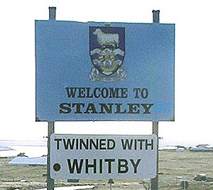
The islands became a strategic point for navigation around Cape Horn. During the California Gold Rush from 1849, would-be prospectors from the east coast of the United States hurried to California and as few were willing to risk the crossing of the wild west, ships laden with them sailed south for the Horn, and Stanley became a gold-rush town, with something of an evil reputation, somewhat hard to imagine given its crime-free status today.
A World War I naval battle, the Battle of Falkland Islands, took place in December 1914, resulting in a British victory over the Imperial German Asiatic Fleet. During World War II, Stanley served as a Royal Navy station and serviced ships which took part in the 1939 Battle of the River Plate.
The islands' first air link began in 1971. The Argentine Air Force, which operates the state airline LADE, began amphibious flights between Comodoro Rivadavia and Stanley using Grumman HU-16 Albatross aircraft. The following year, Britain agreed to allow Argentina to build a temporary air strip, which was completed that November. Flights between Stanley and Comodoro Rivadavia continued twice a week using Fokker F27 and later Fokker F28 aircraft following the construction of the permanent air strip until 1982.[19][20][21] During the same period, the Argentine national oil and gas company supplied the islands' energy needs.
Falklands War
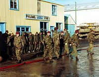
On 2 April 1982, Argentina invaded the Falkland Islands and also South Georgia. The military junta which had ruled Argentina since 1976 sought to maintain power by diverting public attention from the nation's poor economic performance and exploiting the long-standing feelings of the Argentines towards the islands. Several British writers hold that the United Kingdom's reduction in military capacity in the South Atlantic also encouraged the invasion. The Foreign Secretary, Lord Carrington, and two junior ministers had resigned by the end of the week, taking the blame for Britain's poor preparations and plans to decommission HMS Endurance, the Navy's only Antarctic patrol vessel.
The United Nations Security Council issued Resolution 502, calling on Argentina to withdraw forces from the Islands and for both parties to seek a diplomatic solution.[22] International reaction ranged from support for Argentina in Latin American countries (except Chile and Colombia), to opposition in the Commonwealth and Europe (apart from Spain), and eventually the United States.
The British sent an expeditionary force to retake the islands, leading to the Falklands War. After short but fierce naval and air battles, the British landed at San Carlos Water on 21 May, and a land campaign followed until the Argentine forces surrendered on 14 June 1982.
The war resulted in the deaths of 255 British and 649 Argentine soldiers, sailors and airmen, as well as of three civilian Falklanders.
After the war, the British military presence on the islands was increased. RAF Mount Pleasant was built and the garrison was increased such that for several years there were more soldiers than civilians on the islands. The United Kingdom and Argentina did not resume diplomatic relations until 1992.
Economy
The largest company in the islands used to be the Falkland Islands Company (FIC), a publicly quoted company on the London Stock Exchange. The company was responsible for the majority of the economic activity on the islands, though its farms were sold in 1991 to the Falkland Islands Government. The company now operates several retail outlets in Stanley and is involved in port services and shipping operations.
Except for defence, the islands are self sufficient; exports account for more than $125 million a year (2004 estimate).
Farming
Farmland accounts for more than 90% of the Falklands land area.[23] Since 1984, efforts to diversify the economy have made fishing the largest part of the economy and brought increasing income from tourism.[24] Sheep farming was formerly the main source of income for the islands and still plays an important part with high quality wool exports going to the UK. According to the Falklands Government Statistics there are over 500,000 sheep on the islands with roughly 60% on East Falkland and 40% on West Falkland.[23]
Fishing
The government has operated a fishing zone policy since 1986 with the sale of fishing licences to foreign countries. These licences have recently raised only £12 to 15 million a year in revenue, reduced from £20m to £25m annually during the 1990s. Locally registered fishing boats are also in operation. More than 75% of the annual catch of 220,000 ton are squid.[25]
Tourism
Tourism has grown rapidly. The islands have become a regular port of call for the growing market of cruise ships with more than 36,000 visitors in 2004.[26] Attractions include the scenery and wildlife conservation with penguins, seabirds, seals and sealions, as well as visits to battlefields, golf, fishing and wreck diving.
Oil
Geological surveys showed there might be up to 60 billion barrels of oil under the sea bed surrounding the islands. Falklands Oil and Gas Limited signed an agreement with BHP Billiton to investigate the potential exploitation of oil reserves.[27] Climatic conditions of the southern seas mean that exploitation will be a difficult task, though economically viable, and the continuing threats by Argentina are hampering progress.[28] In February 2010, exploratory drilling for oil was begun by Desire Petroleum,[29] but the results from the first test well were disappointing.[30] Two months later, on 6 May 2010, Rockhopper Exploration announced that "it may have struck oil".[31] On Friday 17th September 2010 Rockhopper Exploration released news that a flow test of the Sea-Lion 1 discovery was a commercially viable find.[32]
People
Census figures show that the population rose from an estimate of 287 in 1851 to 2272 in 1911. It was 2094 in 1921 and 2392 in 1931 but then it declined and in 1980 the population was 1813. The population then rose and was 2955 in 2006. The 2006 census recorded 2115 people in Stanley and 477 in Mount Pleasant, 194 in the rest of East Falkland, 127 in West Falkland and 42 people in all the other islands. These figures exclude all military personnel and their families, but includes 477 people who were present in the Falkland Islands in connection with the military garrison.[33]
About 70% are of British descent.[34] The native-born inhabitants call themselves "Islanders"; the term "Kelpers", from the kelp which grows profusely around the islands, is no longer used in the Islands. People from the United Kingdom who have obtained Falkland Island status are known locally as 'belongers'.
A few Islanders are of French, Gibraltarian, Portuguese and Scandinavian descent. Some are the descendants of whalers who reached the Islands during the last two centuries. There is also a small minority of South American descent, mainly Chilean, and in more recent times many people from St Helena have also come to work and live in the Islands.[35]
The main religion is Christianity and the main denomination is Church of England, with some Roman Catholics, United Free Church and Lutherans. Smaller numbers of Jehovah's Witnesses, Seventh-day Adventists and Greek Orthodox are found; the latter due to Greek fishermen passing through.
As from 1 January 1983, the islanders have been full British citizens.
Education
Education is compulsory and free between five and sixteen, and follows the English system. There is a primary school and a secondary school with boarding facilities in Stanley. There are also several rural settlement schools, travelling teachers for children living remotely and a primary school for children of service personnel at RAF Mount Pleasant. After 16, suitably qualified students may study at two colleges in England for their A-levels or for vocational qualifications. The government pays for older students to attend higher education, usually in the UK.[36]
Broadcasting and telecommunications
Broadcasting
Radio services are operated by the Falkland Islands Radio Service, formerly the Falkland Islands Broadcasting Service, and the British Forces Broadcasting Service (BFBS). FM stereo broadcasting using the UK allocation is standard. Medium Wave broadcasting using 10 kHz steps.
The only terrestrial channel available is BFBS1. PAL television, using the UK UHF allocation standard. There is also a cable television service in Stanley operated by KTV Ltd.
Telephone
The Falkland Islands has a modern telecommunications network providing fixed line telephone, ADSL and dial-up internet services in Stanley. Telephones to outlying settlements use microwave radio. A GSM 900[37] mobile network was installed in 2005[38] providing coverage to Stanley, Mount Pleasant and surrounding areas. It is operated under the Touch Mobile brand.
Cable & Wireless Worldwide is the sole telecommunications provider in the Falkland Islands.[39]
Transport
The Falkland Islands have two airports with paved runways. The main international airport is RAF Mount Pleasant, 27 miles west of Stanley.[40] There are weekly flights, operated by LAN Airlines, to Santiago, Chile, by way of Punta Arenas. Once a month, this flight also stops in Río Gallegos, Argentina.[41]
The Royal Air Force operates flights from RAF Mount Pleasant to RAF Brize Norton in Oxfordshire, with a refuelling stop at RAF Ascension Island. RAF flights are on TriStars although charter aircraft are often used if the TriStars are required for operational flights. At present Omni Air International operates the RAF air link, using DC-10s. British International (BRINTEL) also operate two Sikorsky S61N helicopters, based at RAF Mount Pleasant, under contract to the Ministry of Defence, primarily for moving military personnel, equipment and supplies around the islands.
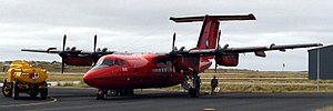
The British Antarctic Survey operates a transcontinental air link between the Falkland Islands and the Rothera Research Station on the Antarctic Peninsula and servicing also other British bases in the British Antarctic Territory using a de Havilland Canada Dash 7.
The smaller Port Stanley Airport, outside the city, is used for internal flights. The Falkland Islands Government Air Service (FIGAS) operates Britten-Norman Islander aircraft that can use the grass airstrips that most settlements have. Flight schedules are decided a day in advance according to passenger needs. The night before, the arrival and departure times are announced on the radio.
The road network has been improved in recent years. However, not many paved roads exist outside Stanley and RAF Mount Pleasant. Speed limits are 25 mph in built-up areas and 40 mph elsewhere.[42]
Military
There is a British military garrison stationed on the Falkland Islands, but the islands also have their own Falkland Islands Defence Force, a volunteer corps. This company-sized force is completely funded by the Falklands government. It uses vehicles such as: quad bikes, inflatable boats and Land Rovers to traverse the islands' terrain. The Falkland Islands Defence Force uses the Steyr AUG as its main assault rifle.
References
- ↑ [http://www.falklands.info/history/histarticle19.html 'Port Desire and the Discovery of the Falklands' by Peter J. Pepper (Falkland Islands Newsletter, No. 78, March 2001)
- ↑ [http://falklandislandsguide.wordpress.com/ Falkland Islands Guide (blog)
- ↑ AGREEMENT OF 14th JULY 1999 - Falklands.info
- ↑ PSYOP of the Falkland Islands War (psywar.org)
- ↑ The Islands: Location (Falkland Islands Government, 2007)
- ↑ Distance between Bird Island and Staten Island
- ↑ Distance between Jason Island and Punta Buque
- ↑ Distance between a rock off Cape Pembroke and Shag Rocks
- ↑ Distance between Beauchêne Island and Seal Island
- ↑ http://www.visitorfalklands.com/assets/documents/falklands-factsheet.pdf
- ↑ 11.0 11.1 History : Falkland Islands : Locations Welcome to the Learning Zone : Visit & Learn (Royal Navy)
- ↑ 12.0 12.1 12.2 Falkland Islands - Britishislesgenweb.org, 20 January 2009
- ↑ Molle, Kris: John Davis - Polar Conservation Organisation, 7 October 2008
- ↑ A brief history of the Falkland Islands Part 2 - Fort St Louis and Port Egmont.. Retrieved 8 September 2007.
- ↑ [1] A Brief History of the Falkland Islands: Part 2 - Fort St Louis and Port Egmont
- ↑ [2] Falkland Islands Timeline: A chronology of events in the history of the Falkland Islands
- ↑ [http://www.falklands.gov.fk/Historical_Dates.html Historical Dates] - The Falkland Islands Government
- ↑ Darwin's Beagle Diary (1831–1836) page 304 (The Complete Works of Charles Darwin Online)
- ↑ [3] Argentine National Congress, Chamber of Deputies. Líneas Aéreas Del Estado, LADE.
- ↑ [4] Asociación Tripulantes de Transporte Aéreo. Argentine Air Force, Grumman HU-16B Albatross.
- ↑ [5] Asociación Tripulantes de Transporte Aéreo. Argentine Air Force, Fokker F-27 Troopship/Friendship
- ↑ United Nations Resolution 502, ''Adopted by the Security Council at its 2350th meeting held on 3 April 1982.'' Historycentral.com
- ↑ 23.0 23.1 "Biennial Report 2008/9". Falklands Island Government Department of Agriculture. 31 May 2009. http://www.agriculture.gov.fk/publications/farming_statistics/2008-2009.pdf. Retrieved 18 April 2010.
- ↑ LA, Paris, Port Stanley?, Frank Kane, The Observer, 4 April 2004
- ↑ "Fisheries". The Falkland Islands Government. http://www.falklands.gov.fk//Fisheries.html. Retrieved 14 Julyl 2010.
- ↑ Sharon Jaffray (22 April 2005). "Four Seasons and more than 3,000 Tourists in One Day". Penguin News. http://www.falklands.info/background/lifearticle31.html.
- ↑ 'BHP Billiton strikes $100m Falklands drilling deal': Carl Mortished, The Times, 3 October 2007
- ↑ Webber, Jude (3 October 2007). "Argentina protests at Falklands oil stake". The Financial Times. http://www.ft.com/cms/s/0/aa2294fe-71d7-11dc-8960-0000779fd2ac.html?nclick_check=1. Retrieved 20 October 2007.
- ↑ "Drilling for oil begins off the Falkland Islands". BBC News. 22 February 2010. http://news.bbc.co.uk/1/hi/8527307.stm. Retrieved 15 March 2010.
- ↑ Clark, Nick (30 March 2010). "Explorers fail to strike oil in test sites off Falklands". The Independent (London). http://www.independent.co.uk/news/business/news/explorers-fail-to-strike-oil-in-test-sites-off-falklands-1930807.html. Retrieved 9 June 2010.
- ↑ "Falklands oil firm Rockhopper claims discovery". BBC News. 6 May 2010. http://news.bbc.co.uk/1/hi/business/10100769.stm. Retrieved 6 May 2010.
- ↑ "Result of Flow Test- Sea Lion 14/10-2". Rockhopper Exploration plc. 17 September 2010. http://www.rockhopperexploration.co.uk/pdf/Result_of_Flow_Test_FINAL_RNS.pdf. Retrieved 2010-09-21.
- ↑ [documents/Census%20Report%202006.pdf "Falkland Islands Census Statistics, 2006"]. Falkland Islands Government. documents/Census%20Report%202006.pdf. Retrieved 4 June 2010.
- ↑ Vincent, Patrick (March 1983). The Geographical Journal, Vol. 149, No. 1, pp 16–17.
- ↑ "UK | Falklands questions answered". BBC News. 4 June 2007. http://news.bbc.co.uk/2/hi/uk_news/6683677.stm. Retrieved 15 March 2010.
- ↑ http://www.falklands.gov.fk/Education.html
- ↑ "GSM coverage in the Falkland Islands". Gsmworld.com. http://www.gsmworld.com/ROAMING/GSMINFO/net_fkcw.shtml. Retrieved 15 March 2010.
- ↑ "Cable and Wireless Falkland Islands". Cwfi.co.fk. http://www.cwfi.co.fk/. Retrieved 15 March 2010.
- ↑ "Telecommunications". falklands.info. http://www.falklands.info/factfile/comms.html. Retrieved 15 March 2010.
- ↑ "43.28 km in Map Crow Travel Distance Calculator". Mapcrow.info. 23 October 2007. http://www.mapcrow.info/Distance_between_London_UK_and_Port_Stanley_FK.html. Retrieved 15 March 2010.
- ↑ "Official Tourism Website of the Falkland Islands". Xtold.visitorfalklands.com. 18 August 2009. http://xtold.visitorfalklands.com/content/view/186/175/. Retrieved 9 June 2010.
- ↑ "The Falkland Islands". Falkland Islands Tourist Board. http://www.falklandislands.com/assets/documents/falklands-factsheet.pdf. Retrieved 19 May 2010.
Further reading
- Graham Pascoe and Peter Pepper Getting it right: the real history of the Falklands/Malvinas. May 2008.
- Thoughts on the Late Transactions Respecting Falkland's Islands by Samuel Johnson 1771