Baxenghyll Gorge: Difference between revisions
Jump to navigation
Jump to search
Created page with "right|thumb|300px|The Beezley Falls in Baxenghyll Gorge {{county|York}}{{riding|West}} '''Baxenghyll Gorge''' is a..." |
|||
| (One intermediate revision by the same user not shown) | |||
| Line 1: | Line 1: | ||
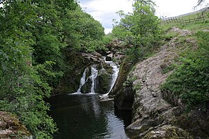
[[File:River Doe Ingleton - geograph.org.uk - 1131607.jpg|right|thumb|300px|The Beezley Falls in Baxenghyll Gorge]] | [[File:River Doe Ingleton - geograph.org.uk - 1131607.jpg|right|thumb|300px|The Beezley Falls in Baxenghyll Gorge]] | ||
{{county|York}}{{riding|West}} | {{county|York}}{{riding|West}} | ||
'''Baxenghyll Gorge''' is a dramatic, steep-sided, rocky gorge carved by the lower reach of the [[River Doe]] through the landscape of the [[West Riding of Yorkshire]], north-east of [[Ingleton]]. A short gorge as it is, it is known for its spectacular waterfalls. | '''Baxenghyll Gorge''' is a dramatic, steep-sided, rocky gorge carved by the lower reach of the [[River Doe]] through the landscape of the [[West Riding of Yorkshire]], north-east of [[Ingleton, Yorkshire|Ingleton]]. A short gorge as it is, it is known for its spectacular waterfalls. | ||
The Ingleton Waterfall Walk runs through the Baxenghyll Gorge to see its cascades. | The Ingleton Waterfall Walk runs through the Baxenghyll Gorge to see its cascades. | ||
| Line 9: | Line 9: | ||
*'''Rival Falls''' have a plunge pool known as the ''Black Hole''. The steepest drops are between 9 feet and 12 feet approximately. | *'''Rival Falls''' have a plunge pool known as the ''Black Hole''. The steepest drops are between 9 feet and 12 feet approximately. | ||
*'''Snow Falls''' are in the lower gorge about half a mile downstream and have similar drops.<ref>{{cite web|url=http://www.ukriversguidebook.co.uk/rivers/england/north-west/river-doe|title=UK River Guide - Doe|accessdate=15 January 2014}}</ref> | *'''Snow Falls''' are in the lower gorge about half a mile downstream and have similar drops.<ref>{{cite web|url=http://www.ukriversguidebook.co.uk/rivers/england/north-west/river-doe|title=UK River Guide - Doe|accessdate=15 January 2014}}</ref> | ||
==Pictures== | |||
{{commons}} | |||
<gallery> | |||
File:Baxenghyll Gorge - panoramio.jpg|In Baxenghyll Gorge | |||
File:Baxenghyll Gorge 2010.jpg|In Baxenghyll Gorge | |||
File:Baxengill Gorge, River Doe, near Ingleton - geograph.org.uk - 830376.jpg|The Doe in the gorge near Ingleton | |||
File:Snow Falls, Yorkshire - geograph-2193604.jpg|Snow Falls | |||
</gallery> | |||
==References== | ==References== | ||
Latest revision as of 20:10, 1 July 2019

Baxenghyll Gorge is a dramatic, steep-sided, rocky gorge carved by the lower reach of the River Doe through the landscape of the West Riding of Yorkshire, north-east of Ingleton. A short gorge as it is, it is known for its spectacular waterfalls.
The Ingleton Waterfall Walk runs through the Baxenghyll Gorge to see its cascades.
Waterfalls in the gorge
- Beezley Falls are reached approximately two miles from the source at God's Bridge. These falls consist of a series of cascades, including the 'triple spout'.
- Rival Falls have a plunge pool known as the Black Hole. The steepest drops are between 9 feet and 12 feet approximately.
- Snow Falls are in the lower gorge about half a mile downstream and have similar drops.[1]
Pictures
| ("Wikimedia Commons" has material about Baxenghyll Gorge) |
-
In Baxenghyll Gorge
-
In Baxenghyll Gorge
-
The Doe in the gorge near Ingleton
-
Snow Falls
References
- Baxenghyll Gorge on My Yorkshire Dales
- ↑ "UK River Guide - Doe". http://www.ukriversguidebook.co.uk/rivers/england/north-west/river-doe. Retrieved 15 January 2014.


