Rumbling Hole: Difference between revisions
mNo edit summary |
No edit summary |
||
| (One intermediate revision by one other user not shown) | |||
| Line 4: | Line 4: | ||
|picture=Rumbling hole entrance rigging.jpg | |picture=Rumbling hole entrance rigging.jpg | ||
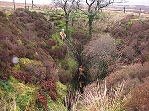
|picture caption=Two cavers rigging the entrance pitch | |picture caption=Two cavers rigging the entrance pitch | ||
|os grid ref= | |os grid ref=SD6717379128 | ||
|latitude=54.206836 | |latitude=54.206836 | ||
|longitude=-2.504781 | |longitude=-2.504781 | ||
|depth= | |depth=390 feet | ||
|length=700 feet | |length=700 feet | ||
|discovery=1932 | |discovery=1932 | ||
| Line 14: | Line 14: | ||
|survey=[http://cavemaps.org/cavePages/Leck%20Fell__Rumbling%20Hole.htm cavemaps] | |survey=[http://cavemaps.org/cavePages/Leck%20Fell__Rumbling%20Hole.htm cavemaps] | ||
}} | }} | ||
'''Rumbling Hole''' is one of the many fenced-off sinkholes near the road on [[Leck Fell]] in [[Lancashire]]. The entrance shaft is approximately | '''Rumbling Hole''' is one of the many fenced-off sinkholes near the road on [[Leck Fell]] in [[Lancashire]]. The entrance shaft is approximately 160 feet deep and often has a small waterfall cascading down the side opposite the three trees that grow at the edge of the vertical shaft, one of which provides a convenient belay point for the entrance pitch.<ref name="rustRH">{{cite book|title=Selected Caves of Britain and Ireland|isbn=1-871890-43-8|year=1997|author=Des Marshal, Donald Rust|publisher=Cordee|location=Leicester}}</ref> | ||
==Exploration== | ==Exploration== | ||
A connection was made between Rumbling Hole and [[Lost John's Cave]] by Lancaster University Speleological Society in 1985.<ref>{{cite web|url=http://www.es.lancs.ac.uk/luss/Exploration/Britain/Discover/lj_rh.html|title=Lost John's Pot/ Rumbling Hole Connection.|author=Colin Boothroyd}}</ref> It is a part of [[ | A connection was made between Rumbling Hole and [[Lost John's Cave]] by Lancaster University Speleological Society in 1985.<ref>{{cite web|url=http://www.es.lancs.ac.uk/luss/Exploration/Britain/Discover/lj_rh.html|title=Lost John's Pot/ Rumbling Hole Connection.|author=Colin Boothroyd}}</ref> It is a part of the [[Three Counties System]], a network of connected caves beneath [[Westmorland]], [[Lancashire]] and [[Yorkshire]]. | ||
During a visit to Rumbling Beck Cave (a short horizontal cave that sinks | During a visit to Rumbling Beck Cave (a short horizontal cave that sinks 100 feet from the main sinkhole and discharges its stream into the main shaft) in late 2007, the Misty Mountain Mud Miners noticed an unexplored hole in the side of the shaft and, over six trips, pushed a new route 1,150 feet long, named the ''Dead Bobbin Series'', down to 390 feet below surface level,<ref>{{cite journal | ||
|author=Dave Ramsay | |author=Dave Ramsay | ||
|date=February–March 2008 | |date=February–March 2008 | ||
| Line 31: | Line 31: | ||
==Entrances== | ==Entrances== | ||
*Rumbling Beck Cave: {{ | *Rumbling Beck Cave: {{wmap|54.206767|-2.505|zoom=14|name=Rumbling Beck Cave}} | ||
*Sink hole {{ | *Sink hole: {{wmap|54.2066|-2.505733|zoom=14|name=sink hole}} | ||
==References== | ==References== | ||
Latest revision as of 17:12, 28 January 2019
| Rumbling Hole | |
| Lancashire | |
|---|---|
 Two cavers rigging the entrance pitch | |
| SD6717379128 | |
| Co-ordinates: | 54°12’25"N, 2°30’17"W |
| Depth: | 390 feet |
| Length: | 700 feet |
| Access: | CNCC Permit |
| Geology: | Limestone |
Rumbling Hole is one of the many fenced-off sinkholes near the road on Leck Fell in Lancashire. The entrance shaft is approximately 160 feet deep and often has a small waterfall cascading down the side opposite the three trees that grow at the edge of the vertical shaft, one of which provides a convenient belay point for the entrance pitch.[1]
Exploration
A connection was made between Rumbling Hole and Lost John's Cave by Lancaster University Speleological Society in 1985.[2] It is a part of the Three Counties System, a network of connected caves beneath Westmorland, Lancashire and Yorkshire.
During a visit to Rumbling Beck Cave (a short horizontal cave that sinks 100 feet from the main sinkhole and discharges its stream into the main shaft) in late 2007, the Misty Mountain Mud Miners noticed an unexplored hole in the side of the shaft and, over six trips, pushed a new route 1,150 feet long, named the Dead Bobbin Series, down to 390 feet below surface level,[3] installing £160 worth of fixed bolts.[4]
Entrances
- Rumbling Beck Cave: 54°12’24"N, 2°30’18"W
- Sink hole: 54°12’24"N, 2°30’21"W
References
- ↑ Des Marshal, Donald Rust (1997). Selected Caves of Britain and Ireland. Leicester: Cordee. ISBN 1-871890-43-8.
- ↑ Colin Boothroyd. "Lost John's Pot/ Rumbling Hole Connection.". http://www.es.lancs.ac.uk/luss/Exploration/Britain/Discover/lj_rh.html.
- ↑ Dave Ramsay (February–March 2008). "News items: Rumbling extension". Descent (200): page 13. SSN 0046-0036. http://www.wildplaces.co.uk/descent/descent200.html.
- ↑ "Rumbling Hole: New Finds". 22 November 2007. http://www.white-rose.org.uk/modules.php?name=AvantGo&op=ReadStory&sid=54.