Ae: Difference between revisions
mNo edit summary |
|||
| (2 intermediate revisions by 2 users not shown) | |||
| Line 14: | Line 14: | ||
|LG district=Dumfries and Galloway | |LG district=Dumfries and Galloway | ||
}} | }} | ||
'''Ae''' is a small village in [[Dumfriesshire]] with a population | '''Ae''' is a small village in [[Dumfriesshire]] with a population of about 200. It lies 7½ miles north of [[Dumfries]], within a 12,500-acre conifer forest, the Forest of Ae. Both the village and the forest take their names from the [[Water of Ae]], a river which flows into the Annan. The name is believed to come from the Old Norse for "river". | ||
Ae's name is listed in the ''Guinness Book of Records'' as having the shortest place-name in Britain (though an uninhabited spot, [[Oa | Ae's name is listed in the ''Guinness Book of Records'' as having the shortest place-name in Britain (though an uninhabited spot, the [[The Oa|Oa]] on the Isle of [[Islay]], may share its crown). The Forest of Ae, to which the village owes its origin, is one of Britain's largest. | ||
Ae is not in one of the main dales of Dumfriesshire but stands between [[Annandale]] and [[Nithsdale]], between the [[Water of Ae]] and the Goukstane Burn. | Ae is not in one of the main dales of Dumfriesshire but stands between [[Annandale]] and [[Nithsdale]], between the [[Water of Ae]] and the Goukstane Burn. | ||
The village was founded in 1947 by the [[Forestry Commission]], and formed the base for experiments in forestry. | The village was founded in 1947 by the [[Forestry Commission]], and formed the base for experiments in forestry. | ||
==Forest of Ae== | ==Forest of Ae== | ||
The [[Forest of Ae]] extends over 12,500 acres and belongs to the Forestry Commission. After the Second World War the Commission conducted a number of successful experiments. Here, for example, the Commission successfully afforested peat bogs, formerly thought to be unplantable. Plantation has also been established on mountain slopes at a height of 1,750 feet. | |||
The Forest of Ae extends over 12,500 acres and belongs to the Forestry Commission. After the Second World War the Commission conducted a number of successful experiments. Here, for example, the Commission successfully afforested peat bogs, formerly thought to be unplantable. Plantation has also been established on mountain slopes at a height of 1,750 feet. | |||
The forest consists mainly of sitka spruce, but there are also larch, Scots pine, and Norway spruce. Wildlife abounds, including deer, foxes, hares and weasels. The forest is also home to a population of red squirrels. Birdlife includes woodpigeons, yellowhammers, sparrowhawks, jays, pheasants and partridges. | The forest consists mainly of sitka spruce, but there are also larch, Scots pine, and Norway spruce. Wildlife abounds, including deer, foxes, hares and weasels. The forest is also home to a population of red squirrels. Birdlife includes woodpigeons, yellowhammers, sparrowhawks, jays, pheasants and partridges. | ||
The Forest remains a working agricultural forest; large quantities of timber are harvested every year, used for many industries from construction and furniture-making to papermaking. New trees are planted each year to replenish the forest for future generations. | The Forest remains a working agricultural forest; large quantities of timber are harvested every year, used for many industries from construction and furniture-making to papermaking. New trees are planted each year to replenish the forest for future generations. | ||
Latest revision as of 13:48, 1 March 2018
| Ae | |
| Dumfriesshire | |
|---|---|
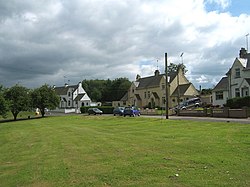
 The village of Ae | |
| Location | |
| Grid reference: | NX983891 |
| Location: | 55°11’10"N, 3°35’49"W |
| Data | |
| Population: | 200 |
| Post town: | Dumfries |
| Postcode: | DG1 |
| Dialling code: | 01387 |
| Local Government | |
| Council: | Dumfries and Galloway |
| Parliamentary constituency: |
Dumfries and Galloway |
Ae is a small village in Dumfriesshire with a population of about 200. It lies 7½ miles north of Dumfries, within a 12,500-acre conifer forest, the Forest of Ae. Both the village and the forest take their names from the Water of Ae, a river which flows into the Annan. The name is believed to come from the Old Norse for "river".
Ae's name is listed in the Guinness Book of Records as having the shortest place-name in Britain (though an uninhabited spot, the Oa on the Isle of Islay, may share its crown). The Forest of Ae, to which the village owes its origin, is one of Britain's largest.
Ae is not in one of the main dales of Dumfriesshire but stands between Annandale and Nithsdale, between the Water of Ae and the Goukstane Burn.
The village was founded in 1947 by the Forestry Commission, and formed the base for experiments in forestry.
Forest of Ae
The Forest of Ae extends over 12,500 acres and belongs to the Forestry Commission. After the Second World War the Commission conducted a number of successful experiments. Here, for example, the Commission successfully afforested peat bogs, formerly thought to be unplantable. Plantation has also been established on mountain slopes at a height of 1,750 feet.
The forest consists mainly of sitka spruce, but there are also larch, Scots pine, and Norway spruce. Wildlife abounds, including deer, foxes, hares and weasels. The forest is also home to a population of red squirrels. Birdlife includes woodpigeons, yellowhammers, sparrowhawks, jays, pheasants and partridges.
The Forest remains a working agricultural forest; large quantities of timber are harvested every year, used for many industries from construction and furniture-making to papermaking. New trees are planted each year to replenish the forest for future generations.