Cargan: Difference between revisions
Created page with '{{Infobox town |name=Cargan |county=Antrim |picture= |picture caption= |os grid ref=D1617 |LG district=Ballymena }} '''Cargan''' is a village in County Antrim. {{stub}}' |
No edit summary |
||
| (2 intermediate revisions by the same user not shown) | |||
| Line 2: | Line 2: | ||
|name=Cargan | |name=Cargan | ||
|county=Antrim | |county=Antrim | ||
|picture= | |picture=Autumnal colours near Cargan - geograph.org.uk - 1547794.jpg | ||
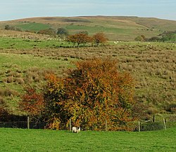
|picture caption= | |picture caption=Near Cargan | ||
|os grid ref= | |os grid ref=D164177 | ||
|LG district= | |latitude=54.993273 | ||
|longitude=-6.1824059 | |||
|population= | |||
|census year= | |||
|post town=Ballycastle | |||
|postcode=BT54 | |||
|dialling code= | |||
|LG district=Mid and East Antrim | |||
|constituency= | |||
}} | }} | ||
'''Cargan''' is a village in [[County Antrim]]. | '''Cargan''' is a small village and a [[townland]] in [[County Antrim]], at the foot of [[Slievenanee]] in [[Glenravel]] – locally known as "The Tenth Glen" (to rate along with the famed Nine [[Glens of Antrim]]. The townland had a population of 588 people (in 223 households) at the 2011 Census. | ||
{{ | The name of the place is from the Gaelic ''an Carraigín'', meaning "the small rock".<ref name=pnni>[http://www.placenamesni.org/resultdetails.php?entry=16344 Placenames NI: Cargan]</ref> It takes its name from Cargan Rock, a hill of 950 feet a short distance east of the village, which has a cairn on its summit. | ||
==History== | |||
One of the earliest anglicisations of the townland of Cargan is 'Carrigan'.<ref name=pnni/> In the late 1800s, the village was known as Fisherstown after the man who, in 1866, opened the first iron ore mines near the village. The ore was shipped to [[Barrow-in-Furness]] in [[Lancashire]], at first by horse and cart to the pier at [[Waterfoot, County Antrim|Waterfoot]] where Fisher had his own ships,<ref>The Mountains of Iron, by K J O'Hagan, Mid-Antrim Part 2, 1991.</ref> then from 1875 by railway to [[Ballymena]] and onwards. The railway closed in 1937.<ref>{{cite web|title=The Drum, County Antrim |work=Woodland Trust |url=http://www.woodland-trust.org.uk/woydni/sitelocationsmoreni/thedrum.htm |accessdate=2007-09-14 |archiveurl=https://web.archive.org/web/20070927190125/http://www.woodland-trust.org.uk/woydni/sitelocationsmoreni/thedrum.htm |archivedate=2007-09-27 |deadurl=yes |df=}}</ref> | |||
==Transport== | |||
The Ballymena to Cargan railway line was opened in 1875 and extended to Parkmore and Retreat in 1876.<ref>{{cite web | author=JRB McMinn | title=The Social and Political Structure of North Antrim in 1869 | work=The Glens of Antrim Historical Society | url=http://www.antrimhistory.net/content.php?cid=135 | accessdate=2007-09-14}}</ref> Cargan railway station opened on 1 June 1894, was closed for passenger traffic on 1 October 1930, and finally closed altogether on 12 April 1937.<ref>{{cite web | title=Cargan station | work=Railscot - Irish Railways | url=http://www.railscot.co.uk/Ireland/Irish_railways.pdf | accessdate=2007-09-14}}</ref> It was on the Ballymena, Cushendall and Red Bay Railway which operated narrow gauge railway services from Ballymena to [[Parkmore, County Antrim|Parkmore]] from 1875 to 1940.<ref>{{cite book |last=Baker |first=Michael HC |title=Irish Narrow Gauge Railways. A View from the Past|publisher=Ian Allan Publishing|year=1999 |isbn=0-7110-2680-7 }}</ref> | |||
==Outside links== | |||
*[http://world.std.com/~ahern/higgins.htm Higgins Family of Glenravel] | |||
==References== | |||
{{reflist}} | |||
Latest revision as of 23:25, 2 November 2017
| Cargan | |
| County Antrim | |
|---|---|
 Near Cargan | |
| Location | |
| Grid reference: | D164177 |
| Location: | 54°59’36"N, 6°10’57"W |
| Data | |
| Post town: | Ballycastle |
| Postcode: | BT54 |
| Local Government | |
| Council: | Mid & East Antrim |
Cargan is a small village and a townland in County Antrim, at the foot of Slievenanee in Glenravel – locally known as "The Tenth Glen" (to rate along with the famed Nine Glens of Antrim. The townland had a population of 588 people (in 223 households) at the 2011 Census.
The name of the place is from the Gaelic an Carraigín, meaning "the small rock".[1] It takes its name from Cargan Rock, a hill of 950 feet a short distance east of the village, which has a cairn on its summit.
History
One of the earliest anglicisations of the townland of Cargan is 'Carrigan'.[1] In the late 1800s, the village was known as Fisherstown after the man who, in 1866, opened the first iron ore mines near the village. The ore was shipped to Barrow-in-Furness in Lancashire, at first by horse and cart to the pier at Waterfoot where Fisher had his own ships,[2] then from 1875 by railway to Ballymena and onwards. The railway closed in 1937.[3]
Transport
The Ballymena to Cargan railway line was opened in 1875 and extended to Parkmore and Retreat in 1876.[4] Cargan railway station opened on 1 June 1894, was closed for passenger traffic on 1 October 1930, and finally closed altogether on 12 April 1937.[5] It was on the Ballymena, Cushendall and Red Bay Railway which operated narrow gauge railway services from Ballymena to Parkmore from 1875 to 1940.[6]
Outside links
References
- ↑ 1.0 1.1 Placenames NI: Cargan
- ↑ The Mountains of Iron, by K J O'Hagan, Mid-Antrim Part 2, 1991.
- ↑ "The Drum, County Antrim". Woodland Trust. Archived from the original on 2007-09-27. https://web.archive.org/web/20070927190125/http://www.woodland-trust.org.uk/woydni/sitelocationsmoreni/thedrum.htm. Retrieved 2007-09-14.
- ↑ JRB McMinn. "The Social and Political Structure of North Antrim in 1869". The Glens of Antrim Historical Society. http://www.antrimhistory.net/content.php?cid=135. Retrieved 2007-09-14.
- ↑ "Cargan station". Railscot - Irish Railways. http://www.railscot.co.uk/Ireland/Irish_railways.pdf. Retrieved 2007-09-14.
- ↑ Baker, Michael HC (1999). Irish Narrow Gauge Railways. A View from the Past. Ian Allan Publishing. ISBN 0-7110-2680-7.