Wolsty: Difference between revisions
Created page with "{{Infobox town |name=Wolsty |county=Cumberland |picture=Wolsty Hall - geograph.org.uk - 96594.jpg |picture caption=Wolsty Hall, one of the farms in the hamlet |os grid ref=NY1..." |
mNo edit summary |
||
| Line 14: | Line 14: | ||
|constituency=Workington | |constituency=Workington | ||
}} | }} | ||
'''Wolsty''' is a small hamlet in [[Cumberland]], found three-and-a-quarter miles south of [[Silloth]], and five miles west of [[Abbeytown]], three-and-a-quarter miles north of the village of [[Mawbray]], and twenty-three miles west of | '''Wolsty''' is a small hamlet in [[Cumberland]], found three-and-a-quarter miles south of [[Silloth]], and five miles west of [[Abbeytown]], three-and-a-quarter miles north of the village of [[Mawbray]], and twenty-three miles west of Cumberland's [[county town]], [[Carlisle]]. | ||
The B5300 coast road, which heads north toward Silloth-on-Solway and south to Mawbray, [[Allonby]], and [[Maryport]], is three-quarters of a mile away by road, or less than a quarter of a mile by way of an unpaved farm track. | The B5300 coast road, which heads north toward Silloth-on-Solway and south to Mawbray, [[Allonby]], and [[Maryport]], is three-quarters of a mile away by road, or less than a quarter of a mile by way of an unpaved farm track. | ||
Latest revision as of 22:51, 20 August 2017
| Wolsty | |
| Cumberland | |
|---|---|
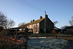
 Wolsty Hall, one of the farms in the hamlet | |
| Location | |
| Grid reference: | NY104509 |
| Location: | 54°50’43"N, 3°23’42"W |
| Data | |
| Post town: | Wigton |
| Postcode: | CA7 |
| Dialling code: | 016973 |
| Local Government | |
| Council: | Cumberland |
| Parliamentary constituency: |
Workington |
Wolsty is a small hamlet in Cumberland, found three-and-a-quarter miles south of Silloth, and five miles west of Abbeytown, three-and-a-quarter miles north of the village of Mawbray, and twenty-three miles west of Cumberland's county town, Carlisle.
The B5300 coast road, which heads north toward Silloth-on-Solway and south to Mawbray, Allonby, and Maryport, is three-quarters of a mile away by road, or less than a quarter of a mile by way of an unpaved farm track.
The name "Wolsty" is derived from the Old English wulf-stig, meaning "wolf path". There have been several recorded variant spellings, including Woulstie, Worsty, Wristie, Wolmsty, and Ulsty.[1]
History
This coastline was part of the Roman fortified line beyond Hadrian's Wall: Milefortlet 13 and Milefortlet 14 are located in the vicinity of the hamlet.[2]
Wolsty appears to have taken part in the "seawake", a night watch along the coast, in which men of coastal communities took turns standing watch along the coast to guard against raids.
To defend the vulnerable Holme Abbey at nearby Abbeytown aganst Scottish raids, a castle was constructed at Wolsty to defend the coast. After falling into disrepair by the 1570s, attempts to repair the castle were undertaken in the 1630s, but it was already strategically redundant and had been demolished by the year 1700. The castle would have proven formidable to raiding parties; remaining archaeological evidence has shown that there was a moat, and that the walls were over six feet thick.[3] The castle remains are scheduled under the Ancient Monuments and Archaeological Areas Act 1979 as a site of "national importance".[4] An archaeological dig was carried out on the site in July 2013.[5][6]
The hamlet today

Wolsty today remains a farming settlement, but it is quite small and has no facilities or amenities of its own. The nearest shops are in Silloth-on-Solway, three-and-a-quarter miles to the north. At nearby Newtown, there is a farm park and tearoom called the Gincase,[7] and Bank Mill Nurseries, a garden centre with a restaurant and play area, is located just to the north of Beckfoot.[8]
Outside links
| ("Wikimedia Commons" has material about Wolsty) |
References
- ↑ Holme St. Cuthbert History Group (2004). Plain People: Bygone Times on the Solway Plain. ISBN 0954882318.
- ↑ National Monuments Record: No. 9682 – Milefortlet 13
- ↑ "Holme Low Parish Council – Wolsty Castle". Archived from the original on 23 January 2015. https://web.archive.org/web/20150123171348/http://www.holmelow-pc.org.uk/page27.html. Retrieved 24 February 2015.
- ↑ National Heritage List 1023508: Wolsty Castle
- ↑ "Holme Low Parish Council – Wolsty Castle". Archived from the original on 23 January 2015. https://web.archive.org/web/20150123171348/http://www.holmelow-pc.org.uk/page27.html. Retrieved 24 February 2015.
- ↑ "Grampus – St Christian's Chapel and Wolsty Castle geophysical surveys and excavations". http://www.grampusheritage.co.uk/projects/solway-wetlands-landscape-partnership-scheme-lps/wolsty-castle-and-st-christians-chapel-geophysical-surveys-and-excavations/. Retrieved 24 February 2015.
- ↑ "The Gincase". http://gincase.co.uk. Retrieved 24 February 2015.
- ↑ "Bank Mill Nurseries". http://www.bankmillnurseries.co.uk. Retrieved 24 February 2015.
