Albyfield: Difference between revisions
Jump to navigation
Jump to search
Created page with "{{Infobox town |name=Albyfield |county=Cumberland |picture=Albyfield Farm Near Cumrew, taken from my Paraglider - geograph.org.uk - 378515.jpg |picture caption=An aerial view..." |
No edit summary |
||
| Line 16: | Line 16: | ||
'''Albyfield''' is a tiny hamlet of no more than a couple of farms at the end of a lane in [[Cumberland]]. | '''Albyfield''' is a tiny hamlet of no more than a couple of farms at the end of a lane in [[Cumberland]]. | ||
It is to be found at the eastern edge of the dale of the [[River Eden, Cumberland and Westmorland|River Eden]], at the edge of the [[Cheviots]]: [[Cumrew Fell]] (1,580 feet) rises on the eastern edge of the farms, with the open country known as the [[King's Forest of | It is to be found at the eastern edge of the dale of the [[River Eden, Cumberland and Westmorland|River Eden]], at the edge of the [[Cheviots]]: [[Cumrew Fell]] (1,580 feet) rises on the eastern edge of the farms, with the open country known as the [[King's Forest of Geltsdale]] beyond, up to Cumberland's border with [[Northumberland]]. | ||
==Outside links== | ==Outside links== | ||
{{commons}} | {{commons}} | ||
Latest revision as of 16:00, 13 June 2017
| Albyfield | |
| Cumberland | |
|---|---|
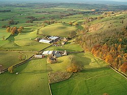
 An aerial view of Albyfield Farm | |
| Location | |
| Grid reference: | NY548523 |
| Location: | 54°51’49"N, 2°42’19"W |
| Data | |
| Post town: | Brampton |
| Postcode: | CA8 |
| Dialling code: | 01768 |
| Local Government | |
| Council: | Cumberland |
| Parliamentary constituency: |
Penrith and The Border |
Albyfield is a tiny hamlet of no more than a couple of farms at the end of a lane in Cumberland.
It is to be found at the eastern edge of the dale of the River Eden, at the edge of the Cheviots: Cumrew Fell (1,580 feet) rises on the eastern edge of the farms, with the open country known as the King's Forest of Geltsdale beyond, up to Cumberland's border with Northumberland.
Outside links
| ("Wikimedia Commons" has material about Albyfield) |
