Cockley Beck: Difference between revisions
Jump to navigation
Jump to search
Created page with "{{Infobox town |name=Cockley Beck |county=Lancashire |picture=Cockley Beck Bridge - geograph.org.uk - 49694.jpg |picture caption=Cockley Beck Bridge, looking southwest over th..." |
mNo edit summary |
||
| Line 19: | Line 19: | ||
The hamlet is within the [[Lake District]]. | The hamlet is within the [[Lake District]]. | ||
The hamlet itself was established in the late 16th century, and is closely associated with the mining of copper ore in [[Furness]].<ref> | The hamlet itself was established in the late 16th century, and is closely associated with the mining of copper ore in [[Furness]].<ref>[http://www.cumbria-industries.org.uk/copper.htm Cooper] – Local Industries</ref> | ||
{{commons}} | {{commons}} | ||
==References== | ==References== | ||
{{reflist}} | {{reflist}} | ||
Latest revision as of 12:40, 19 May 2017
| Cockley Beck | |
| Lancashire | |
|---|---|
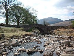
 Cockley Beck Bridge, looking southwest over the bridge | |
| Location | |
| Grid reference: | NY246015 |
| Location: | 54°24’14"N, 3°9’40"W |
| Data | |
| Post town: | Broughton-in-Furness |
| Postcode: | LA20 |
| Dialling code: | 01229 |
| Local Government | |
| Council: | Westmorland & Furness |
| Parliamentary constituency: |
Barrow and Furness |
Cockley Beck is a small hamlet on the eastern side of Dunnerdale, which divides Lancashire (on which side Cockley Beck is found) from Cumberland.
The hamlet is within the Lake District.
The hamlet itself was established in the late 16th century, and is closely associated with the mining of copper ore in Furness.[1]
| ("Wikimedia Commons" has material about Beck Cockley Beck) |
