Difference between revisions of "Leven Viaduct"
(Created page with "{{Infobox bridge |name=Leven Viaduct |county=Lancashire |picture=Leven Viaduct from Canal Foot - geograph.org.uk - 99723.jpg |picture caption=The Leven Viaduct from Canal Foot...") |
m |
||
| Line 15: | Line 15: | ||
|height=26 feet | |height=26 feet | ||
}} | }} | ||
| − | The '''Leven Viaduct''' is a railway viaduct a third of a mile long across the [[River Leven, Lancashire|Leven Estuary]] between the [[Cartmel Peninsula]] and [[Ulverston]] on the [[Furness]] Peninsula, the two peninsulas of [[Lancashire North of the Sands]] extending into [[ | + | The '''Leven Viaduct''' is a railway viaduct a third of a mile long across the [[River Leven, Lancashire|Leven Estuary]] between the [[Cartmel Peninsula]] and [[Ulverston]] on the [[Furness]] Peninsula, the two peninsulas of [[Lancashire North of the Sands]] extending into [[Morecambe Bay]]. |
The railway line joins [[Barrow in Furness]] to Ulverston to [[Grange-over-Sands]] and then by way of the [[Kent Viaduct]] over the sands to the rest of [[Lancashire]]. Until the coming of the railway, Lancashire North of the Sands was isolated from the rest of the county by the fells. | The railway line joins [[Barrow in Furness]] to Ulverston to [[Grange-over-Sands]] and then by way of the [[Kent Viaduct]] over the sands to the rest of [[Lancashire]]. Until the coming of the railway, Lancashire North of the Sands was isolated from the rest of the county by the fells. | ||
Latest revision as of 22:18, 16 May 2017
| Leven Viaduct | |
| Lancashire | |
|---|---|
 The Leven Viaduct from Canal Foot | |
| Location | |
| Carrying: | Furness Railway |
| Crossing: | Leven Estuary |
| Location | |
| Grid reference: | SD322785 |
| Location: | 54°11’52"N, 3°2’22"W |
| Structure | |
| Length: | 1,575 feet |
| History | |
| Information | |
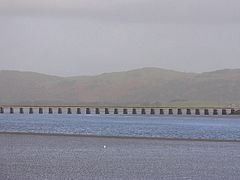
The Leven Viaduct is a railway viaduct a third of a mile long across the Leven Estuary between the Cartmel Peninsula and Ulverston on the Furness Peninsula, the two peninsulas of Lancashire North of the Sands extending into Morecambe Bay.
The railway line joins Barrow in Furness to Ulverston to Grange-over-Sands and then by way of the Kent Viaduct over the sands to the rest of Lancashire. Until the coming of the railway, Lancashire North of the Sands was isolated from the rest of the county by the fells.
The viaduct has 49 spans and is 1,575 feet long. It was originally built in 1848 to 1857 and reconstructed in wrought iron in 1880. The tracks were set at a height of 26 feet above water level. The viaduct was widened to accommodate twin tracks in 1863, and major repairs were carried out in 1915. These included replacement of the original deck and the encapsulation, in brickwork and concrete, of the original cast iron piers which had deteriorated.
The viaduct is included within the limits of a site of special scientific interest, a special conservation area and protected bird areas.
A causeway was built along the alignment of the viaduct and used to construct the original viaduct. The remains of that causeway can still be seen today.
