Bramley, Derbyshire: Difference between revisions
Jump to navigation
Jump to search
Created page with "{{Infobox town |name=Bramley |county=Derbyshire |picture=Bramley Park Caravan Site, Marsh Lane, NE Derbyshire - geograph.org.uk - 121985.jpg |picture caption=Bramley Park. |os..." |
No edit summary |
||
| Line 11: | Line 11: | ||
|postcode=S21 | |postcode=S21 | ||
|dialling code= | |dialling code= | ||
|LG district= | |LG district=North East Derbyshire | ||
|constituency= | |constituency= | ||
}} | }} | ||
'''Bramley''' is a village in [[Derbyshire]], immediately west of [[Eckington, Derbyshire|Eckington]] (and within the latter's parish). | '''Bramley''' is a village in [[Derbyshire]], immediately west of [[Eckington, Derbyshire|Eckington]] (and within the latter's parish). | ||
Bramley is within a mile of the [[ | Bramley is within a mile of the boundary of the city of [[Sheffield]], marked by a minor stream named "The Moss". However, the outer suburbs of the Sheffield conurbation lie in Derbyshire, and it is not until the aptly named "Shire Brook" is reached that we pass into [[Yorkshire]]. | ||
{{stub}} | {{stub}} | ||
Latest revision as of 20:06, 9 February 2017
| Bramley | |
| Derbyshire | |
|---|---|
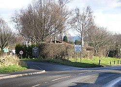
 Bramley Park. | |
| Location | |
| Grid reference: | SK408797 |
| Location: | 53°18’48"N, 1°23’18"W |
| Data | |
| Post town: | Sheffield |
| Postcode: | S21 |
| Local Government | |
| Council: | North East Derbyshire |
Bramley is a village in Derbyshire, immediately west of Eckington (and within the latter's parish).
Bramley is within a mile of the boundary of the city of Sheffield, marked by a minor stream named "The Moss". However, the outer suburbs of the Sheffield conurbation lie in Derbyshire, and it is not until the aptly named "Shire Brook" is reached that we pass into Yorkshire.

This Derbyshire article is a stub: help to improve Wikishire by building it up.