St Stephen-by-Launceston: Difference between revisions
Created page with '{{Infobox town |name=St Stephen-by-Launceston |county=Cornwall |postcode=PL15 |latitude=50.645247 |longitude=-4.369557 |os grid ref=SX325855 |picture= St Stephens by Launceston, …' |
|||
| (One intermediate revision by the same user not shown) | |||
| Line 16: | Line 16: | ||
The population of St Stephen at the 2001 census was 312. | The population of St Stephen at the 2001 census was 312. | ||
The village lies immediately northwest of the town of Launceston and is about it are to the south [[St Thomas-by-Launceston]], and [[Lawhitton]], to the east beyond Lanstephan is the [[River Tamar]] and to the north and northwest the parishes of [[Werrington, | The village lies immediately northwest of the town of Launceston and is about it are to the south [[St Thomas-by-Launceston]], and [[Lawhitton]], to the east beyond Lanstephan is the [[River Tamar]] and to the north and northwest the parishes of [[Werrington, Devon|Werrington]], [[North Petherwin]] and [[Egloskerry]]. | ||
==Parish church== | ==Parish church== | ||
| Line 33: | Line 33: | ||
==References== | ==References== | ||
{{reflist}} | {{reflist}} | ||
Latest revision as of 13:12, 13 July 2016
| St Stephen-by-Launceston | |
| Cornwall | |
|---|---|
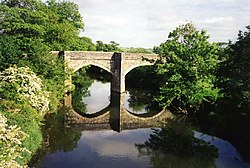
 Higher New Bridge, St Stephen-by-Launceston | |
| Location | |
| Grid reference: | SX325855 |
| Location: | 50°38’43"N, 4°22’10"W |
| Data | |
| Postcode: | PL15 |
| Local Government | |
| Council: | Cornwall |
St Stephen-by-Launceston is a village in the east of Cornwall sitting just north of Launceston across the River Kensey, built on the steep hillside of that river's valley.
St Stephen may be said to be the original Launceston, for the latter name is from the Cornish Lansteffan; "Stephen's Church" (still seen in the name of the village or suburb abutting it, Lanstephan) but the name of Lansteffan was lost to the town over the river when the castle was built there and all the privileges of St Stephen's carried off there.
The population of St Stephen at the 2001 census was 312.
The village lies immediately northwest of the town of Launceston and is about it are to the south St Thomas-by-Launceston, and Lawhitton, to the east beyond Lanstephan is the River Tamar and to the north and northwest the parishes of Werrington, North Petherwin and Egloskerry.
Parish church

The parish church, dedicated to St Stephen, is within the northern outskirts of the town of Launceston at SX324857. The church's buttressed and battlemented tower (16th century) houses a ring of six bells.
The church was built in the early 13th century after the monastery which had been on this site had moved into the valley near Launceston Castle. The old tower was demolished by Reginald Earl of Cornwall. The present fine tower was built in the 16th century; the font is Norman. On the Tamar at Yeolmbridge is the oldest bridge in Cornwall: it has two pointed arches and the roadway has been widened in modern times.
History
In Anglo-Saxon times there was a monastery here dedicated to St Stephen whose canons owned the surrounding land including the town of Launceston (Lan-stefan-ton), a name later to be taken over by next door Dunheafod / Dunheved. A mint was established here as early as the reign of Ethelred II in 976, but only one specimen of a coin is known to exist.[1][2]
After the Norman Conquest the Norman Earl acquired Dunheved and rebuilt the castle there. He expropriated the market and mint of the canons and the townspeople followed them to Dunheved.[3] The name of Launceston which had belonged originally to the monastery and town here was then transferred to the town of Dunheved.)
The church of St Stephen retained its importance and remained the mother church of many of the surrounding parishes, Tremaine, Egloskerry, Tresmeer, Werrington, St Giles, Laneast, St Thomas, St Mary Magdalene and others throughout the Middle Ages.[4]